10 Year Anniversary of the Joplin Tornado of May 22, 2011

The infamous Joplin tornado looming over the city. This photo was likely taken by a storm chaser and publicized by NWS Springfield.
While the 2011 Super Outbreak in late April had been a disaster of unprecedented magnitude, tornado season still had more in store, this time for the central United States. On May 21st, another tornado outbreak would commence, resulting in almost as many deaths as the Super Outbreak.
Intense activity had begun on the 21st, with 1 person killed by an EF3 tornado in Reading, Kansas, and tornadoes progressed through the state. However, the worst was yet to come, and the most fatal tornado since 1947 would arrive the next day. The location that would be subject to this undue, sobering tragedy, would be the city of Joplin, Missouri.
Weather Forecasts
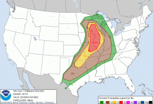
In the first Day 1 Convective Outlooks, early in the morning of May 22nd, though it was widespread and stretched from Texas to Wisconsin, only a slight risk was forecast. While Convective Available Potential Energy (CAPE) values were high, temperature inversions in the middle atmosphere and weakening low level winds were expected to suppress most activity, resulting in only a 10% significant tornado risk. By the 1630z (11:30AM CDT) outlook, forecast conditions had become more conducive, prompting the issuance of a moderate risk with a 15% significant tornado threat from central Missouri to central Wisconsin, as shown on the right. This was the final outlook before the commencement of the outbreak just two and a half hours later, and the Storm Prediction Center noted that an imminent band of supercells would develop, with a favorable orthogonally oriented shear vector. The SPC forecast that, eventually, with CAPE values near 2000-3000 J/kg, the supercells could develop into a quasi-linear convective system, colloquially known as a squall line, over the Ohio valley.
This forecast actually verified rather well, with almost all tornadic activity occurring inside the moderate risk zone. Furthermore, tornadic activity would not be excessive, as it had been during the Super Outbreak, with only 49 tornadoes and 12 significant tornadoes. While this was a very widespread outbreak of tornadoes, no one expected the impending catastrophe of an EF5.
Severe Weather Event
Supercells quickly developed near the west edge of the forecast severe risk shortly after the issuance of the 1630z convective outlook, and tornado watches 322, 323, 325, and 326 were issued from the Wisconsin-Minnesota border through Illinois, Iowa, central Missouri, eastern Oklahoma, and into North Texas. The first tornado touched down in the suburbs of Minneapolis at 2:15PM CDT as a large wedge tornado rated EF1. This tornado caused a fatality after a tree fell on to a man’s car, beginning the soon to be catastrophic day terribly. Near simultaneous tornadoes developed 18 minutes later in Howard County, Iowa, and Price County, Wisconsin, rated EF2 and EF1, respectively. The Wisconsin tornado caused minor damage, but the Iowa tornado tracked 28 miles on the ground into Fillmore County, Minnesota and injured 4. Only 7 minutes after the first EF2, another EF2 developed close by in Iowa County, Iowa, causing major damage to homes and snapping trees and power poles.
A short lull in significant tornado activity then persisted until 4:00PM CDT, when an EF2 tornado passed Hokah, Minnesota, causing minor damage. Following this, an EF2 touched down in La Crosse, Wisconsin and damaged over 200 homes and businesses and an ice arena. Another short lull in significant tornado activity until a tornado that would be rated EF2 touched down northwest of Tomah, Wisconsin. This tornado would go on to track 69 miles over an hour and 15 minutes, causing damage to thousands of trees and power poles, some of which damaged homes. Two homes were destroyed at the beginning of the tornado path, while a third was severely damaged as well. The tornado continued to track through multiple communities in Wisconsin, causing damage to a cranberry farm near Finley, and damaging farming equipment and homes along its path.
As the Tomah tornado tracked through Wisconsin, the tornado that would define this day, the Joplin Tornado, would touch down at 5:34PM CDT at the western edge of Joplin, Missouri. Touchdown was pinpointed near the intersection of JJ Highway and West 32nd Street. Early on in the tornado’s lifetime, spotters noted that there were already multiple vortices swirling within the circulation, and the tornado was strong enough to topple multiple trees. As it moved northeast into Joplin, the tornado quickly intensified and widened, leaving behind a path of extreme damage. The tornado struck St. John’s Regional Medical Center at EF5 intensity, the highest rating on the Enhanced Fujita scale, and was rated such due to the extreme structural damage to the building and the catastrophic effects in other areas of the path. Steel structural beams had been warped and the structure was distorted to the point to which the building was torn down for being structurally compromised. Other damage in the area includes concrete walls being rammed into house foundations and the concrete parking stops commonly seen in parking lots being ripped from the ground and thrown tens of yards.
EF5 damage was sustained through a corridor from the medical center to St. Mary’s Catholic Church and the Joplin High School. The Greenbriar Nursing Home, along this path, was utterly destroyed, causing 21 fatalities. Incredible winds were also noted along the Joplin High School, where steel beams were deformed similarly to the deformation in St. John’s Regional Medical Center, and cardboard was found embedded in stucco walls. The tornado continued producing violent damage as it approached Range Line Road, where a Walmart, a Home Depot, and the Pepsi distribution center were completely destroyed. Here, the tornado likely reached its peak width, producing a damage path approximately a mile wide, and ripped manhole covers out of the ground. In a Pizza Hut at 1901 South Range Line Road, the manager, Christopher Lucas, sealed customers and staff into a walk-in freezer and manually held the door closed before being violently ripped out and killed in the tornado. His actions likely saved the lives of over a dozen people and were covered by local media after the storm.
The EF5 damage swath finally ended minutes before the tornado struck the East Middle School, causing major damage to the building. At this point, the tornado had turned to the southeast, and would continue to move further in a southerly direction before its demise. As the tornado continued, it struck the intersection of Interstate 44 and US Route 71, causing EF3 damage and blowing automobiles off the roadway. From here, the tornado moved out of Joplin and caused EF0 to EF1 damage just south of the city before lifting east of Diamond at 6:12PM CDT, 38 minutes after it touched down.
In just 38 minutes, Joplin had been devastated. Along with the 21 who died at Greenbriar Nursing Home and the heroic Christopher Lucas, five were killed at St. John’s Regional Medical Center after the tornado cut off critical life support to patients, and 131 others had died along the tornado’s path. This death toll of 158 was the highest for a single tornado since the 1947 Glazier-Higgins-Woodward tornado. Over a thousand others were injured, and the total damage to the city was an estimated 2.8 billion dollars. The tornado serves as a reminder that maintaining one’s safety is paramount. Always monitor tornado warnings and take all steps necessary to ensure your own safety from severe weather.
However, the day’s event was not yet over. Immediately after the Joplin Tornado lifted, the same supercell developed an EF2 that struck the community of Wentworth, damaging homes and trees. By this point, the focus of tornado activity switched to Oklahoma, where an EF2 developed in Delaware County at 6:33PM EDT, also damaging homes and uprooting trees. Seven mobile homes were completely destroyed along this tornado’s path, and some damage to homes was noted to be major. 19 minutes later, another tornado touched down in Delaware County, and crossed into Missouri in its northwesterly track before gaining EF3 strength, destroying a brick house, a metal structure, and rolling automobiles hundreds of yards. A final tornado in Missouri developed at 7:10PM CDT, destroying turkey barns and farm outbuildings through Stone and Taney Counties.
An hour long lull in significant tornado activity commenced, before the last 2 significant tornadoes of the day developed in Delaware County, Oklahoma in quick succession just after 8:00PM CDT. These tornadoes caused major damage to homes and trees, and the second injured 12 people. After these final significant tornadoes dissipated, activity would wind down over the next half hour before the final tornado developed at 8:54PM CDT in Benton County, Arkansas. As such, the day concluded with a total of 49 tornadoes, 12 significant tornadoes, and an unimaginably violent EF5.
159 people died on May 22nd. Even if there weren’t that many tornadoes, the outbreak clearly shows why it only takes one tornado in the wrong place to cause a disaster. The outbreak would continue until the 26th of May, producing another EF5 and almost 50 more deaths. To this day, the Joplin Tornado is still the costliest single tornado in history, and the impact of 159 lives lost will cement the 22nd of May, 2011, as one of the worst days in US weather history.
Sources:
“2011 Joplin Tornado.” Wikipedia, Wikimedia Foundation, 14 May 2021, en.wikipedia.org/wiki/2011_Joplin_tornado.
“List of Tornadoes in the Tornado Outbreak Sequence of May 21–26, 2011.” Wikipedia, Wikimedia Foundation, 25 Aug. 2020, en.wikipedia.org/wiki/List_of_tornadoes_in_the_tornado_outbreak_sequence_of_May_21%E2%80%9326,_2011.
Person. “10th Commemoration of Joplin, Missouri EF-5 Tornado.” ArcGIS StoryMaps, Esri, 19 May 2021, storymaps.arcgis.com/stories/d64c8d41c28949bd87478f252ac7e378.
“Previous SPC Convective Outlooks Issued on :” Storm Prediction Center, www.spc.noaa.gov/cgi-bin-spc/getacrange.pl?date0=20110522.
“Storm Prediction Center Convective Watch Archives.” Storm Prediction Center, www.spc.noaa.gov/cgi-bin-spc/getww.pl?target=20110522.
-wer
