2 Systems Affecting Australia This Week

Tropical Storm Blake is affecting the NW Australian Coast including North and West Kimberly. Also, in the Australian Region there is invest 92s which has a chance of becoming a major cyclone and making landfall somewhere near Darwin and then skimming the NW Australian Coast like Blake. Unlike Blake, 92s does not make landfall from the latest model runs in the NW Australian Coast and becomes an intense cyclone that goes out to sea. Both systems have the chance of bringing much needed rain to Southern Australia which is in a fire emergency right now, but the main questions are for both of these systems are the intensity, track, and rainfall potential.
Blake
Blake is located at 17.9S and 121.8E with winds of 50mph and a pressure of 988mb according to Force Thirteen. It is moving across the Australian Coast and is going to make landfall either today or tomorrow and has had a degrading appearance due to its close proximity to land. Its remnants will dive into Southern Australia and hopefully bring much needed rain to them.
Rainfall
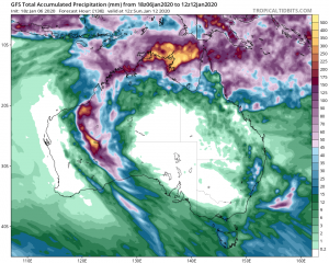
Rainfall will hopefully not be a huge issue but areas near the landfall could receive up to 400mm of rain. Also, the remnants of Blake could possibly bring rainfall to Southern Australia relieving the situation there.
Overall, the track of Blake is clear and it does not look like Blake will intensify anymore, but the heavy rainfall could make issue to those who live in NW Australia.
92s
92s is located 10.7S and 137.2E with winds of 30mph and a pressure 1004mb. 92s is likely going to be a way more intense and affect way more people than Blake, so if you live anywhere near Darwin or the Northern Australian coast please keep a close eye on this system.
Track
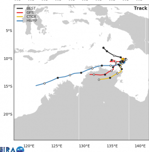
The track of the system is likely to go through somewhere near Darwin after that long range models like to take it out to sea as an intense tropical cyclone. The track puts many people in danger and could amass to lots of rainfall for people that live near or on the Northern Australian Coast.
Intensity
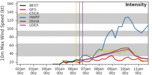
92s is not going to be that strong at landfall near Darwin (Probably just a tropical storm), but after that it will probably take full use of its environment and become an intense cyclone as it tracks out to sea. Even if its not strong people should take it seriously because even tropical storms can kill too.
Overall, 92s seems like a threatening system and people in the area of impact should take it seriously, so they don`t get taken off guard when the system begins to affect them.
Works Cited
- www.tropicaltidbits.com “Forecast Models, GFS, 18z Monday Jan 6, Australia, Forecast Hour 132, Total Accumulated Precip (mm)” https://www.tropicaltidbits.com/analysis/models/?model=gfs®ion=aus&pkg=apcpn&runtime=2020010618&fh=24 Accessed 6 Jan. 2020.
- http://rammb.cira.colostate.edu/ “TC Real Time, 92s, Model Statistics, Multi Model Analytics” https://rammb-data.cira.colostate.edu/tc_realtime/storm_model_data.asp?storm_identifier=sh922020 Accessed 6 Jan. 2020.
