Subtropical Storm Issa Develops off of South Africa, Associated Flooding Causes Devastation
 " title="Subtropical Storm Issa Develops off of South Africa, Associated Flooding Causes Devastation" decoding="async" fetchpriority="high" srcset="https://www.force-13.com/wp-content/uploads/2022/04/cira-rammb-slider-meteosat-8-full_disk-geocolor-opacity-100-20220412184500-1024x481.png 1024w, https://www.force-13.com/wp-content/uploads/2022/04/cira-rammb-slider-meteosat-8-full_disk-geocolor-opacity-100-20220412184500-300x141.png 300w, https://www.force-13.com/wp-content/uploads/2022/04/cira-rammb-slider-meteosat-8-full_disk-geocolor-opacity-100-20220412184500-768x361.png 768w, https://www.force-13.com/wp-content/uploads/2022/04/cira-rammb-slider-meteosat-8-full_disk-geocolor-opacity-100-20220412184500.png 1536w" sizes="(max-width: 640px) 100vw, 640px">
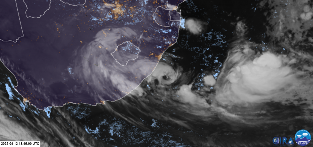
Without any notice of its formation chances or marked as an invest, a non-tropical low off the eastern coast of South Africa formed yesterday afternoon as a gale-force subtropical depression in Meteo-France La Reunion (MFR) scale and thus given the name Issa at 14:00 SAST (12:00 UTC). As it has been designated, it continues to intensify. Currently, it is still subtropical, with 10-min winds of 95km/h. Issa’s precursor low has brought prolonged rainstorms over Durban, South Africa. So far at least 59 fatalities have been reported, with 45 solely in Durban Metro.
Current Storm Information
As of 20:00 SAST (18:00UTC), according to the latest advisory of MFR, Issa is located at 31.1S 31.1E, with estimated maximum 10-minute winds of 95km/h, with gusts reaching hurricane-force (130km/h), and a pressure of 994hPa.
Issa is moving southeast at 13km/h.
At the same time, estimates from ATCF suggest Issa is weaker, with maximum 1-minute winds of 75km/h, but a slightly deeper pressure of 993hPa.
Issa’s Formation Process
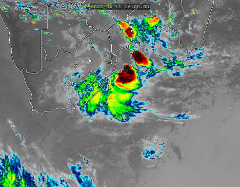
An upper-level trough persisted over Southern Africa since last week and has been slowly moving eastward. It brought prolonged unstable weather over the eastern part of South Africa and the Kingdom of Lesotho, while bringing clear weather behind (west of) the low. The induced convergence at the lower level led to a formation of a surface non-tropical low on April 11th off the coast near the South Africa-Mozambique border, bringing even more serious rainstorms to the eastern coast of South Africa, This low was the precursor of Issa (Pre-Issa).
As it became traceable on the 11th, models such as ECMWF and GFS started to indicate signs of formation. GFS shows it to become a barotropic system in the later 12th to early 13th. The forecast is reflected as relatively accurate as the pre-Issa skirted along the coast and continues to develop under a decent 25-26C sea-surface temperature. Wind shear continues to decline as the upper-level low approaches it, favouring its formation. ASCAT passes showed it was gale-force, with a defined low-level centre.
As it develops, it continued to obtain tropical characteristics. At 14:00 SAST, Meteo-France upgraded this low into a gale-force subtropical depression with 10-min winds of 45mph and a pressure of 997hPa. ATCF followed suit and designated it as subtropical storm 92S.
Right after it formed, development and appearance became more pronounced, with convection wrapping rapidly and eliminating extratropical characteristics. An eye-like feature formed after sunset in various satellite imagery. GFS vertical cross-section shows the warm core extending up to mid-level (300mb), with high level (above 300mb up to tropopause) remaining dominant by the upper-level low as potential vorticity is still positive, supporting that Issa is a subtropical storm. Given the recent improvement, MFR estimated that it intensified into a storm-force subtropical depression, from 75km/h to 95km/h.
Forecast Track
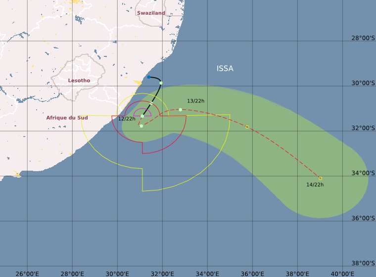
It is expected to be a short-lived system. Under the steering of the subtropical high, it is expected to continue moving southward in general, and weakens substantially, before accelerating southeastward and turning extratropical on the 14th as an extratropical low moving eastward creates a fracture in the subtropical high and picks it up.
Torrential rainfall over the eastern part of South Africa.
Due to the impact of the upper-level low and Issa, it brought rainstorms to the Kingdom of Lesotho and the southeastern part of South Africa, particularly in Kwazulu Natal. Based on surface observations, at least 600mm of rainfall has been recorded in areas near Port Edward and Durban over the past 5 days, with over 310mm dumped solely on the 12th, The outer rainbands of Issa are also bringing strong winds (41-62km/h) near the mentioned areas, with a gust of 59km/h recorded in Port Edward at 20:00 SAST.
This rainstorm that started last Friday has caused severe flooding and mudslides. Structures are flooded. Walls and roads collapse due to excess intrusion of rainwater. At least 59 died, with 45 in Durban. More are still missing. The rainstorm also paralyzed road traffic, water and electric supplies, causing struggles in rescuing operations because only one helicopter is available to lift people out of danger, as local media reported. Hence, the KZN government has called for deploying the South African National Defence Force (SANDF) to facilitate the rescue.
The mayor of EThekwini, Thomas Mxolisi Kaunda, said the disaster management teams are trying their best to rescue communities and save lives and are making effort to resume water and electric supplies as well. He also apologized to those who failed to get through the emergency call centre to the centre “overwhelmed” by the number of calls.
Locals have been posting the aftermath scenes on social media:
More aftermath scenes on Twitter can be found with the hashtag #KZNFloods.
The content on external sites does not represent Force Thirteen’s stance.
Please stay safe for those under the impact of the rainstorm as unstable weather is expected to continue for the next day or two.

[…] Explainer: Why KZN was flooded and why it’s likely to happen again Devastated KZN communities search for family members swept away by floodwaters South African Floods Kill 395, one of the Deadliest Flooding Events in South African History Subtropical Storm Issa Develops off of South Africa, Associated Flooding Causes Devastation […]