Tropical Storm Nalgae moving closer to the Philippines

A huge tropical storm is inching closer to the Philippines this evening Philippine time with Tropical Storm Nalgae, and fatalities are already being reported in parts of the country.
Current Information
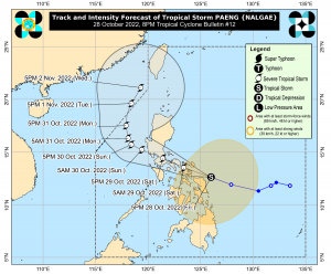
As of Force Thirteen’s 8pm Philippine time (12pm UTC) update, Tropical Storm Nalgae is located at 12.8 degrees north, 125.1 degrees east, with 1-minute sustained winds of 65 mph (100 kph), and a central pressure of 987 millibars, derived from Dvorak estimates and surface observations in Catarman, Northern Samar reporting a pressure of 994.0 mb near its south eyewall, and is further verified by the Courtney-Knaff-Zehr wind/pressure relationship. The Philippine Atmospheric, Geophysical and Astronomical Services Administration (PAGASA) currently estimates Nalgae to have 10-minute winds of 50 mph (85 kph), and a pressure of 990 millibars. The storm is currently moving west-northwest at 16 mph (25 kph).
Current Warnings
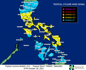
A Signal #2 Warning, meaning tropical storm-force winds will affect the locality within 24 hours, is in effect for:
- Catanduanes, Albay, Sorsogon, Masbate including Ticao and Burias Islands, Camarines Sur, Camarines Norte, Marinduque, Quezon including Pollilo Islands, Laguna, Batangas, Cavite, Metro Manila, Rizal, Bulacan, the southern portion of Aurora, the central and southern portions of Nueva Ecija, the central and southern portions of Tarlac, Pampanga, Bataan, the central and southern portions of Zambales, the northern and central portions of Oriental Mindoro, the northern and central portions of Occidental Mindoro including Lubang Islands, and Romblon
- Northern Samar, Eastern Samar, Samar, Biliran, and the northern portion of Leyte
A Signal #1 Warning, meaning near gale-force winds will affect the locality within 36 hours, is in effect for:
- The central and southern portions of Isabela, Nueva Vizcaya, Quirino, Benguet, Ifugao, Mountain Province, the southern portion of Ilocos Sur, La Union, the rest of Aurora, the rest of Nueva Ecija, the rest of Zambales, Pangasinan, the rest of Tarlac, the rest of Oriental Mindoro, the rest of Occidental Mindoro, Calamian Islands, and Cuyo Islands
- Southern Leyte, Cebu including Bantayan and Camotes Islands, Bohol, Negros Occidental, Negros Oriental, Guimaras, Aklan, Antique, Capiz, Iloilo, Siquijor, and the rest of Leyte
- Dinagat Islands, Surigao del Norte including Siargao and Bucas Grande Islands, the northern portion of Surigao del Sur, Agusan del Norte, the northeastern portion of Agusan del Sur, Camiguin, and the eastern portion of Misamis Oriental
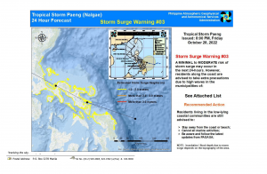
A Storm Surge Warning is also in effect for most of Bicol Region, the southern coast of Aurora, the northern coast of Northern Samar, Eastern Samar, and parts of Samar (Calbayog City and Sta. Margarita).
Current Threats
RAINFALL: Heavy to intense with at times torrential rains likely over Bicol Region and Eastern Visayas are to be expected tonight through tomorrow, as well as moderate to heavy with at times intense rains over Quezon, MIMAROPA, Caraga, Zamboanga Peninsula, BARMM, Northern Mindanao, and the rest of Visayas. Light to moderate with at times heavy rains are forecast over over Metro Manila, Bulacan, Pampanga, Cagayan Valley, Aurora, the rest of CALABARZON, and the rest of Mindanao.
Heavy to torrential rains likely over Aurora, Metro Manila, Bulacan, Nueva Ecija, CALABARZON, Mindoro Provinces, Romblon, Marinduque, Camarines Norte, and Camarines Sur are expected tomorrow early morning through Sunday morning, as Nalgae moves through. Meanwhile, moderate to heavy with at times intense rains are forecast to be experienced over Cagayan Valley, Cordillera Administrative Region, Western Visayas, and the rest of Central Luzon and Bicol Region. Light to moderate with at times heavy rains possible over Zamboanga Peninsula and the rest of Luzon and Visayas.
Heavy rain areas may be updated in the succeeding bulletins should there be significant shifts in the track and intensity forecast of the storm.
WINDS: Winds may reach gale-force strength during the passage of PAENG within any of the areas where Tropical Cyclone Wind Signal No. 2 is hoisted. Strong winds may be experienced within any of the areas where Tropical Cyclone Wind Signal (TCWS) No. 1 is hoisted throughout the entire passage of PAENG.
The surge of the Northeast Monsoon enhanced will also bring strong winds with gusts reaching gale-force strength over Batanes, Babuyan Islands, Ilocos Norte, the northern and eastern portions of mainland Cagayan, and the northern portion of Apayao.
STORM SURGE: There is minimal to moderate risk of storm surge of up to 2.0 m in height which may cause flooding in the low-lying and exposed coastal areas of Bicol Region, Marinduque, Quezon including Pollilo Islands, the eastern portion of Aurora, the northern and eastern portions of Northern Samar, and the eastern portion of Eastern Samar.
Stay safe from this storm, and be sure to listen to local officials for the latest updates, and to us as we continue to cover this storm’s progress.
