98L moves offshore, expected to develop off US East Coast

Invest 98L has moved offshore after tracking through the southeastern United States over the last several days. It is expected to organize into a tropical or subtropical cyclone in a day or so as it tracks northward.
98L is currently a weak and disorganized low pressure system, although as it passes over favorable conditions, 98L is likely to organize and pick up strength. The National Hurricane Center and Force Thirteen both analyze 98L to have a 70% chance of formation as of noon on July 8. It is still unknown whether 98L will be fully tropical or subtropical, but it is likely to form regardless.
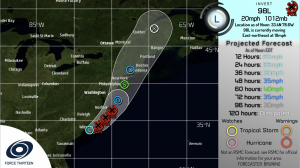
Impacts from 98L could potentially stretch from the Outer Banks to New England over the next several days. The primary impact will likely be heavy rainfall, with flash flooding possible throughout the storm’s path in areas with heavier totals. Gusty winds may also be a concern during the storm’s passage, and rough surf is possible for a good portion of the mid-Atlantic coast all the way up through New England.
For further official information, refer to your local meteorological office. Force Thirteen is also providing more updates on 98L and other storms around the world on their YouTube channel, as well as their Facebook and Twitter accounts.

Predictions: Max. Winds: 55 mph
Max. Wind Gusts: 60 mph
Landfalls: Outer Banks, NC, Long Island, NY, Southern Conneticut, Halifax, Canada
I meant Connecticut.