Tropical Storm Marco Forms over the Northwestern Caribbean; Forecast to Strengthen as a Potential Threat to the U.S Gulf Coast

Tropical Depression Fourteen, which formed over the western Caribbean Sea on Thursday, has become better organized this evening. An Air Force Reconnaissance aircraft investigating the system confirmed that the depression has strengthened, and, accordingly, the National Hurricane Center (NHC) has reclassified it as Tropical Storm Marco. It is the thirteenth named storm of the 2020 Atlantic hurricane season, and the fourth in the month of August, following closely behind currently active Tropical Storm Laura, as well as tropical storms Josephine and Kyle from last week. Marco is currently located over the northwestern Caribbean Sea, about midway between Honduras and the Yucatàn Peninsula, and is forecast to strengthen over the next several days as it moves generally northwestward over the Caribbean Sea and Gulf of Mexico. Marco is expected to pass near the Yucatàn Peninsula tomorrow, where it could be near hurricane strength, and approach the U.S Gulf Coast early next week, and interests in this region should keep a close eye on this tropical cyclone.
Tropical Storm Marco: Current Storm Information
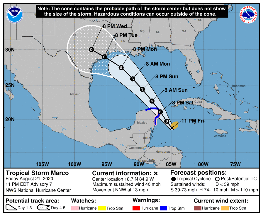
As of the National Hurricane Center’s most recent advisory on Marco at 11:00 PM EDT (15:00 UTC), the center of Tropical Storm Marco was located near 18.7°N, 84.9°W, about 180 mi (290 km) southeast of Cozumel, Mexico. Maximum sustained winds are near 40 mph (65 km/h) with gusts to 50 mph (85 km/h), the minimum central pressure is 1003 mb (29.62 inches), and tropical storm-force winds extend outward up to 90 miles (150 km) from the center. Marco is moving toward the north-northwest at around 13 mph (65 km/h), and a slightly slower northwestward motion is expected through the next few days, followed by an increase in forward speed early next week. On the NHC’s forecast track, the center of Marco will approach the eastern coast of the Yucatàn Peninsula tomorrow, and move over the Gulf of Mexico on Sunday. Additional strengthening is expected through Saturday, and Marco could be near hurricane strength when it nears the Gulf of Mexico over the weekend. Slight weakening is currently expected before Marco reaches the U.S Gulf Coast, although the NHC forecast is of high uncertainty.
Forecast Track, Intensity Guidance, and Hazards Affecting Land
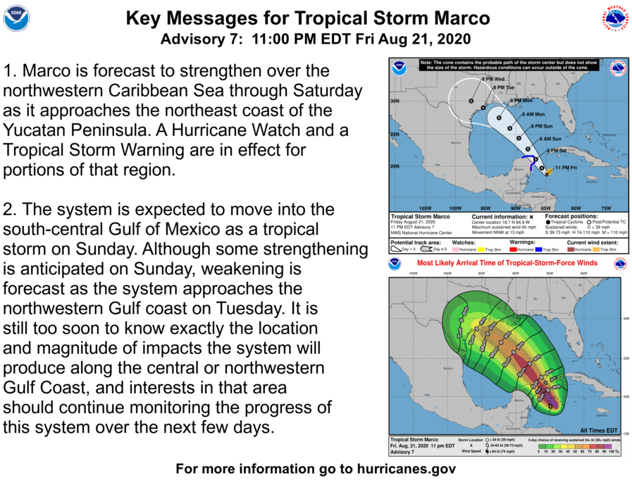
Both the track and intensity aspects of Marco’s forecast are rather uncertain at this time. Model track guidance shows considerable spread, with the weaker GFS and ECMWF ensembles taking a weaker Marco further westward over the western Gulf of Mexico towards the Texas coast. On the other hand, the stronger HWRF and HMON solutions depict a stronger cyclone tracking generally northward toward the southern Louisiana coast. Currently, the NHC forecast track lends more weight to the former, and shows Marco moving generally northwestward until moving over the upper Texas coast early next week. As for how strong Marco might get, both the GFS and ECMWF show very little development, whereas the dynamical guidance is more supportive of strengthening. Marco is a rather small tropical cyclone, and it is well known that small cyclones such as Marco are often prone to rapid changes in intensity, both upwards and downwards. For now, the NHC intensity forecast shows Marco strengthening to a peak of 70 mph (105 km/h), with weakening occuring as it approaches the Gulf Coast due to an expected increase in vertical wind shear from a strong upper-level trough over the Gulf of Mexico. There is also the possibility that Marco’s track and intensity could be influenced by Tropical Storm Laura, which is forecast to be approaching the Gulf of Mexico as Marco is already present. Given the high uncertainty in the forecast, stay alert for potentially large changes in future advisories.
External Links
Please refer to the National Hurricane Center and National Weather Service websites for further information regarding Tropical Storm Marco as well as watches and warnings in effect. Daily updates and Force Thirteen’s live satellite feed of Tropical Storm Marco can be found on the Force Thirteen YouTube channel at https://www.youtube.com/watch?v=6TFVWVMvELo. More information can be found at Force Thirteen’s official outlets, including its Twitter and Facebook pages.
