Remembering the 2011 Super Outbreak: April 25 “Potentially Significant/Dangerous — Severe Weather Threat is Unfolding”

April 25 began as a sunny day across much of the Deep South. It had been 10 days since the last tornado outbreak that had ravaged the region and finally some warm temperatures were setting in. But this wasn’t the case everywhere as over Arkansas thunderstorms plagued the state in the morning as one of the worst outbreaks in US history took shape. This would end up only being the beginning.
Morning Weather Outlooks
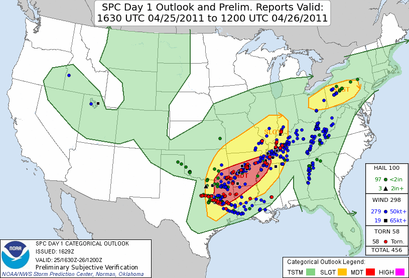
People in the Deep South and the nation woke to see something shocking: 3 Moderate Risk days were issued back-to-back for the Days 1, 2 and 3 outlooks. This was only indicative that a major tornado outbreak would be taking place that day and would potentially be one of historic proportion. The Day 1 outlook for April 25 featured a Moderate Risk for severe weather which included Central and Southern Arkansas, Northeastern Texas, Southwestern Oklahoma, Northern Louisiana, Northwestern Mississippi and Western Tennessee. Here a complex weather scenario was in the making. When the outlook was issued an intense bow echo was moving through the region. Traditionally, the bow echo would eat up the energy in place and make conditions behind it unsuitable for thunderstorm development. But in this case, unstable air (air that would support the development of thunderstorms) from the Gulf would continue to surge into the region meaning that the developing low-pressure system behind the bow echo would have ample moisture to feed off of. Attached to the low-pressure system was a dry line which as it sounds, separates warm, moist air in front of it and warm, dry air behind it. The dry air forces the moist air to rise and rapidly produce thunderstorms and because of strong wind shear (winds blowing in different directions at different speeds in different altitudes of the atmosphere) would promote supercells and tornadoes, which according to the SPC could be strong (EF-2 to EF-3) with large hail and damaging winds also being hazards. These storms would form in Texas and Oklahoma and then sweep east into Arkansas.
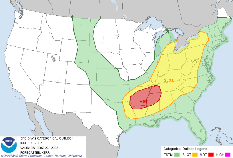
For the Day 2 (April 26) outlook, the SPC also issued a Moderate Risk for a similar area. The outlook initially included Southern Arkansas, extreme Northeastern Texas, Northwestern Mississippi and Western Tennessee but was later expanded to include all of Northern Mississippi and more of Western Tennessee. Here the SPC stated that a ”Complex — but potentially significant/dangerous — severe weather event is unfolding for this area…” as the remnants of the previous days storms would likely be still ongoing in the region. But as the day drew on, moisture was expected to continue to move into the region while shear was expected to strengthen even more which would make a “substantial tornado threat” likely to evolve in the region as a new low-pressure system developed. Very large hail (and damaging winds would also still be likely.
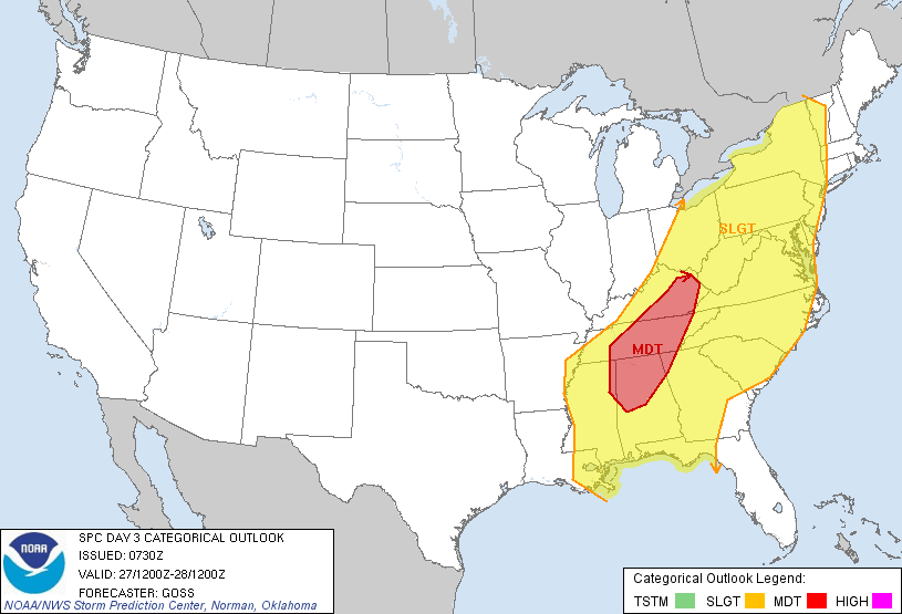
The following day, April 27, the Day 3 outlook also featured a rare moderate Risk but this time mainly for Northern Alabama, Central and Eastern Tennessee and Eastern Kentucky. Here a “…potentially very significant severe weather…” day seemed to be on tap like the 2 previous days but with a more complex setup. Severe storms would once again be ongoing from the previous day which would bring a chance for strong and severe damaging winds to the risk area. On the back end of this, a very unstable air mass would arrive as shear would continue to increase and support rotation. This would support strong tornadoes and damaging winds that as a new low-pressure system interacted with it, were expected to be centered over Tennessee. For the D4 outlook, no areas were assigned as the SPC wasn’t sure when the front from April 28 would arrive with some models moving it fast before suitable conditions arrived for severe weather while some were slower and allowed for a more major severe weather event.
Weather Event
As April 25 began over Arkansas, the lingering bow echo from the previous day continued to move through the state but had weakened below severe limits and didn’t really pose a threat. Meanwhile over Texas, lingering supercells began to redevelop into a bow echo as it moved over Southern Oklahoma at around 5am CDT. This prompted the first Severe Thunderstorm Watch of the outbreak to be issued for parts of Texas, Oklahoma, Louisiana and Arkansas. The line continued to speed east through the morning blasting most of Arkansas with intense winds. But at 9:05am CDT on the southern end of this system, a small funnel touched down over Hempstead County, Arkansas. The tornado would last 8 minutes before lifting and get an EF-0 rating. This tornado would be the first tornado of the outbreak and begin the next 3 days of horror.
Behind this line of storms over Oklahoma and Texas, the dry line did begin to interact with the environment as expected and as early as 10am began to produce thunderstorms around the Tulsa, OK region. These storms began to expand southwest in coverage and began to organize into two lines, one stretched from Muskogee, OK to Ardmore, OK while one in front of it stretched from Waco, TX to Fayetteville, AR. At 11am the first Tornado Watch of the outbreak was issued for Texas, Arkansas and Oklahoma ahead of these storms. These lines moved northeast: the one over Oklahoma organized into a squall line while the one in front stayed more discrete. Tornadoes during this time were mainly isolated to Texas and were weak and brief.
Around 12pm CDT, the two lines of storms began to combine as thunderstorms filled in the holes between them and turn more discrete. But a few hours later a new squall formed right behind the main line. At 3:25pm, the first line of storms stretched from Tyler, TX to Hot Springs, AR and consisted of discrete cells. Behind this line, a squall line of storms posing a risk for damaging winds stretched from Ft. Worth, TX to Fayetteville, AR. This setup prompted the SPC to issue a Particularly Dangerous Situation (PDS) Tornado Watch for most of Arkansas but also Louisiana and Texas meaning a very dangerous tornadic situation was developing and persons in the region should take extra caution.
The squall line began to move faster than the discrete cells and the two lines began to combine. But before all cells had been consumed, two cells dropped two EF-2 tornadoes in Garland Country, AR that caused heavy damage to many communities there including Sunshine and Lake Ouachita injuring 19. After a lull of intense tornadic activity, a new fast-moving cell formed and at 6:07pm CDT dropped a powerful EF-3 tornado that once again tore through communities in Garland County, AR destroying 25 houses and numerous mobile homes killing 1 person as well as blowing down hundreds of trees. This tornado lifted but it then the supercell dropped another large EF-2 tornado that began barreling toward the city of Vilonia, AR, just north of Little Rock. This prompted the first Tornado Emergency of the outbreak as the town was hit head on. It first destroyed a mobile home park where four deaths occurred before roaring through the city and causing immense damages to homes and businesses. 34 houses and 62 mobile homes were destroyed. Because of advanced warning time, only 4 people died and 16 were injured. Meanwhile, another part of the same cell moved through the northwest side of Little Rock, detached itself from the cell and at 7:46pm CDT dropped another significant tornado. It damaged planes at an air force base and also damaged parts of a school in the region before lifting just 8 min. later.
Over Arkansas, the two lines combined into one intense bow echo that began to move through the state. The SPC issued a new PDS Tornado Watch at 4:50pm for Tennessee, Arkansas and small parts of 4 other states ahead of the front, though few tornadoes occurred in those regions. Meanwhile, 2 cells had detached themselves from the main line of storms and moved southeast across Eastern Texas, moving from just south of Dallas/Ft. Worth to the Louisiana/Texas border. they were very isolated but did produce about 15 EF-0 and EF-1 tornadoes in the state.
By midnight as the bow echo moved through Tennessee and Kentucky, the tornado threat ended. That day 42 tornadoes had touched down across 6 states including 4 EF-2 and 1 EF-3. 5 people were killed and 59 were injured. The line of storms continued into the next day, but this had only been a small taste of what was to come. April 26 would be would end up being a more intense day than this.
Sources:
https://en.wikipedia.org/wiki/List_of_tornadoes_in_the_2011_Super_Outbreak
https://en.wikipedia.org/wiki/2011_Super_Outbreak
https://www.spc.noaa.gov/exper/archive/event.php?date=20110425
https://www.spc.noaa.gov/products/outlook/archive/2011/day2otlk_20110425_0600.html
https://www.spc.noaa.gov/products/outlook/archive/2011/day2otlk_20110425_1730.html
https://www.spc.noaa.gov/products/outlook/archive/2011/day3otlk_20110425_0730.html
https://www.spc.noaa.gov/products/exper/day4-8/archive/2011/day4-8_20110425.html
https://mesonet.agron.iastate.edu/current/mcview.phtml?prod=usrad&java=script&mode=archive&frames=300&interval=5&year=2011&month=4&day=25&hour=0&minute=0
https://gis.ncdc.noaa.gov/maps/ncei/radar
