Alvin Dissipates; New East Pacific Disturbance Likely to Become a Tropical Depression Over the Weekend

After having lacked deep convection for several hours, Tropical Depression Alvin, a former hurricane, degenerated into a post-tropical remnant low today. The National Hurricane Center (NHC) issued its last advisory on Alvin at 8:00 AM PDT (15:00 UTC), declaring the cyclone to have became a post-tropical cyclone. Alvin’s remnant low is expected to continue to move west-northwestward to northwestward before dissipating on Sunday.
All Eyes on a New System
Meanwhile, a new tropical disturbance, labeled Invest 94E by the United States Navy, is being monitored for signs of tropical cyclone development. As of 18:00 UTC June 29, Invest 94E was located in the Northeast Pacific basin at 9.2°N, 105.7°W. Maximum sustained winds were 30 mph (45 km/h), and the minimum barometric pressure was 1007 mb (29.74 inches). As of the most recent Tropical Weather Outlook issued by the NHC, Invest 94E had a high (90%) chance of becoming a tropical cyclone during the next 24 hours, and a high (90%) chance of becoming a tropical cyclone during the next few days. The disturbance consists of a broad area of low pressure, associated with a tropical wave, and accompanied by abundant shower and thunderstorm activity. The disturbance has been gradually becoming more organized throughout the day, and a tropical depression is very likely to develop during the next day or two as the system moves westward to west-northwestward at about 15 mph over the open waters of the Eastern North Pacific Ocean. If this system becomes a tropical cyclone, it will receive the name Barbara, which is the next name on the predetermined list of names to be used this year in this basin. The Tropical Weather Outlook also features another system which is expected to develop by the middle of next week well south of the southern coast of Mexico. Environmental conditions will be favorable for development of this system, as well.
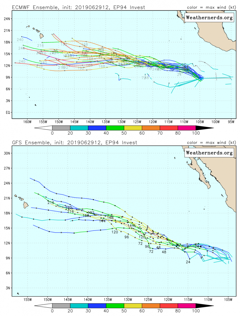
The general consensus among computer models regarding the track of Invest 94E is that the system will move west-northwestward to northwestward across the open waters of the Eastern North Pacific Ocean. This track will likely take the system into the Central North Pacific basin, which is monitored by the Central Pacific Hurricane Center (CPHC), which is responsible for warning on tropical cyclones forming or moving into the region between 140°W and 180°W. There is less agreement between the models regarding the system’s future intensity. The ECMWF (European) ensembles show a stronger cyclone which takes a more westward track, thus keeping it further south and over warmer ocean waters. On the other hand, the GFS (American) ensembles show a weaker system which goes further north, into a region of cooler sea surface temperatures where intensification is less likely. Regardless of the future track and intensity of this system, its very likely that there will be more tropical cyclones forming in this region during the next few weeks, as conditions remain very favorable for the development of tropical cyclones.
Force Thirteen will deliver a live Tropical Weather Bulletin at 8:00 PM EDT (00:00 UTC) today on its YouTube Channel. Further information regarding current tropical cyclone activity can be found at Force Thirteen’s Twitter and Facebook pages.
