Arthur Moving Away from the Outer Banks of North Carolina; Hazardous Surf and Marine Conditions Continue

After making a close pass to Cape Hatteras and the Outer Banks of North Carolina, Tropical Storm Arthur is now accelerating northeastward away from the coast. Although the storm has strengthened today, its tenure as a tropical cyclone is ending as the storm begins to lose its tropical characteristics. As of the most recent advisory from the National Hurricane Center (NHC) at 5:00 PM EDT (21:00 UTC), the center of Tropical Storm Arthur was located near 36.1°N, 73.9°W, about 110 mi (175 km) northeast of Cape Hatteras, North Carolina. Maximum sustained winds are near 50 mph (65 km/h) with gusts to 65 mph (100 km/h), and the minimum central pressure is 993 mb (29.32 inches). The cyclone is moving northeastward at around 16 mph (26 km/h), and a turn to the east-northeast is expected to begin tonight, followed by a slower southeast or south-southeastward motion from Tuesday night through Wednesday. On the NHC’s forecast track, Arthur will continue to move away from the East Coast of the United States, and the storm is forecast to lose its tropical characteristics by Tuesday morning.
Forecast Track, Intensity Guidance, and Hazards Affecting Land
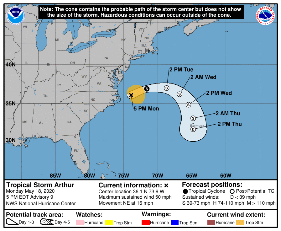
Arthur is not expected to maintain its tropical cyclone status for much longer, although additional intensification is still likely during the next 12 hours or so due to baroclinic processes, which often work to aid in deepening of a tropical or subtropical cyclone when strong pressure gradients exist at the middle latitudes. Numerical Weather Models nearly unanimously agree on Arthur becoming post-tropical within the next 24 hours and taking a north-northeastward, then southward track over the western Atlantic as a post-tropical cyclone. The NHC forecast track follows the model guidance, and shows Arthur passing near Bermuda as a post-tropical cyclone at the end of the forecast period.
While Arthur is now moving away from the coast and all tropical cyclone advisories have now been discontinued, hazardous surf and marine conditions are expected to continue across the Southeastern and Mid-Atlantic U.S coasts during the next day or two. Swells generated by Arthur could produce hazardous conditions for mariners as well as dangerous surf and rip current conditions along the coast. Please refer to the National Hurricane Center and your local National Weather Service office for further information regarding Tropical Storm Arthur.
External Links
Please refer to the National Hurricane Center and National Weather Service websites for further information regarding Tropical Storm Arthur as well as watches and warnings in effect. More information can be found at Force Thirteen’s official outlooks, including its Twitter and Facebook pages.
