Atlantic Wakes Up- New Area of Interest Designated

Approximate region of development for the area of interest.
Overview
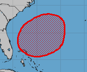
The National Hurricane Center has designated a new area of interest today – with a high chance of development in the next five days. This area of interest is expected to form just to the northeast of the Bahamas, and about 100 miles of the East Coast of the United States. If the system develops, it will be the first named storm of the season (receiving the name Arthur,) and form before the main period of tropical cyclone development in the Atlantic Basin.
In Depth Look
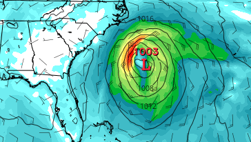
Currently, the area of interest has a 70% chance of development in the next five days and will have a marginally conducive environment for tropical cyclone development. This system will likely develop fairly slowly, and will most likely be a subtropical storm if it does form. The GFS currently has the system developing into a weak subtropical storm and moves the disturbance quickly into the open waters after developing. This motion and track is echoed by the ECMWF, which has the storm slightly weaker but overall similar, moving to the north and east and gradually speeding up as it does so.
Although this disturbance is expected to stay away from land, Force Thirteen is committed to bringing you updates on this storm and those yet to come.
Model run graphics courtesy of Tropical Tidbits, and AOI graphics courtesy of the National Hurricane Center.
