Atlantic’s first Area of Interest develops

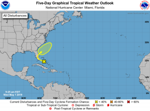
5 day outlook from the NHC
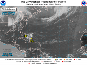
A tropical disturbance has formed over the Bahamas, and has captured the eyes of the National Hurricane Center. As of 10:00 AM EDT, the NHC gives the system a 0% chance of development in 48 hours, and a 20% chance in 5 days. The general thinking of this system’s track is following the southeastern U.S. coast, while moving slowly northeastwards over the next few days. Regardless if this system develops or not, heavy rainfall is likely over Florida & The Bahamas over the next few days.
Models
Not many models are predicting any sort of development of this system. The GFS runs the system into Florida as a weak disturbance, and tracks it up the coast inland. The NAVGEM is similar to the GFS. The ECMWF potentially develops the system into a weak tropical depression after pulling away. Either way, this system is probably going to be short lived, as shear is currently high over the system, and is expected to remain that way, though it could decrease a little bit, allowing for additional development of the system.
As hurricane season is quickly approaching, only 31 days away as of May 1st, make sure you and your family have a plan in case a hurricane comes to your town. Stay tuned to Force Thirteen, as we will provide any additional updates on this system, if it forms, and additional storms in the future.

If this does somehow develop, this will be the 6th consecutive year in a row for the Atlantic that begins with an early season storm.
It would be the 5th. 2014 did not have an early season storm.