Cristobal Closing In On Gulf Coast

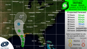
Tropical Storm Cristobal has continued to gradually restrengthen over the past day. As of the latest estimates, Cristobal is producing maximum sustained winds of around 50 mph and a minimum central pressure of 994 mbar, making it a moderate tropical storm. Cristobal has begun to also cause impacts the Gulf Coast, despite being a full day away from landfall.
Cristobal only has a little more than a day left over water, and only a small amount of additional strengthening is anticipated due to dry air continuing to disrupt the inner core, as well as its very large size. The anticipated peak for Cristobal to reach is 60 mph, and Cristobal is expected to make landfall around that intensity as well per the NHC and F13 forecasts. Afterwards, Cristobal is expected to weaken as it tracks northward along the Mississippi Valley, likely losing tropical characteristics over the mid-Mississippi Valley and dissipating soon after.
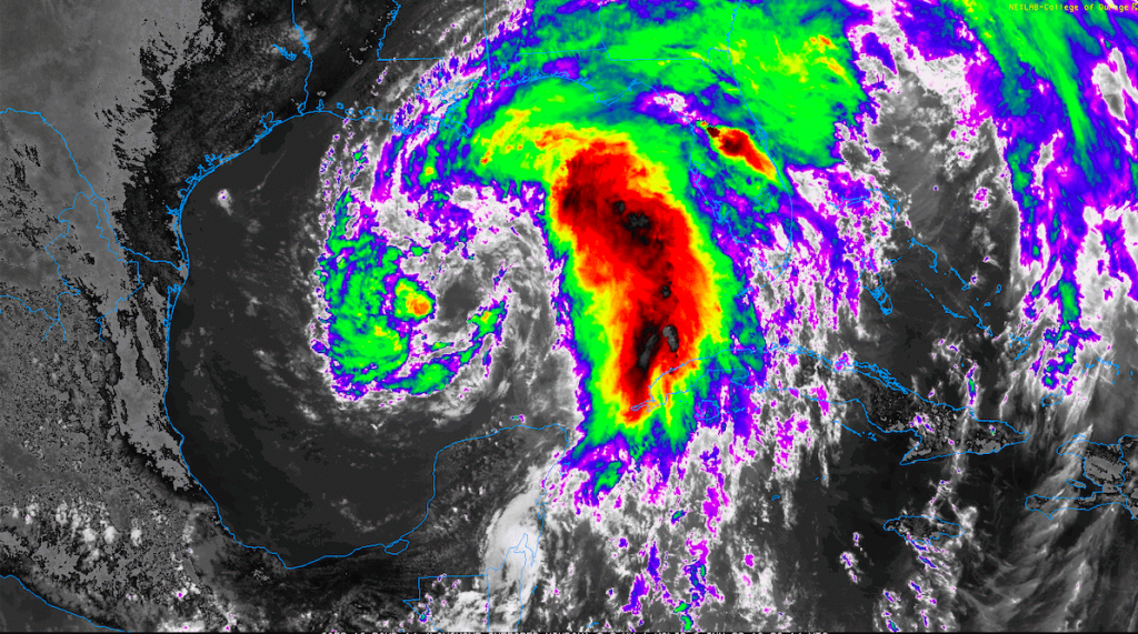
Cristobal has grown to be a large tropical cyclone, with gale-force winds spanning a diameter of almost 350 miles. Because of this, impacts are expected even for areas far away from the storm’s center, and have already begun to occur in coastal areas. Several tornado warnings were reported in Florida earlier today, and conditions are expected to continue deteriorating throughout the Gulf Coast over the next day.
Storm surge is expected to impact the Gulf Coast, with the highest surge occurring along coastline between the mouth of the Mississippi River and Ocean Springs, MS. Areas between Morgan City, LA, and Marco Island, FL, could also see surge related impacts. A Tropical Storm Warning also extends from Intracoastal City, LA, all the way to the western Florida Panhandle, and tropical storm conditions could begin to impact the shoreline as early as tonight. Rainfall is also expected to be a significant impact, although expected totals have not changed much. Rainfall totals of 4-8 inches are still expected in the Lower Mississippi Valley and Gulf Coast, with isolated maxima to 12 inches possible in these areas. Further north, the rainfall is expected to taper off, although parts of the mid-Mississippi valley are likely to see totals of 2-4 inches with maxima to 6 inches.
For the latest official information, please refer to the National Hurricane Center.
Force Thirteen also produces regular updates on their Twitter page and YouTube channel.
