Cristobal Restrengthens into a Tropical Storm, Targets Gulf Coast

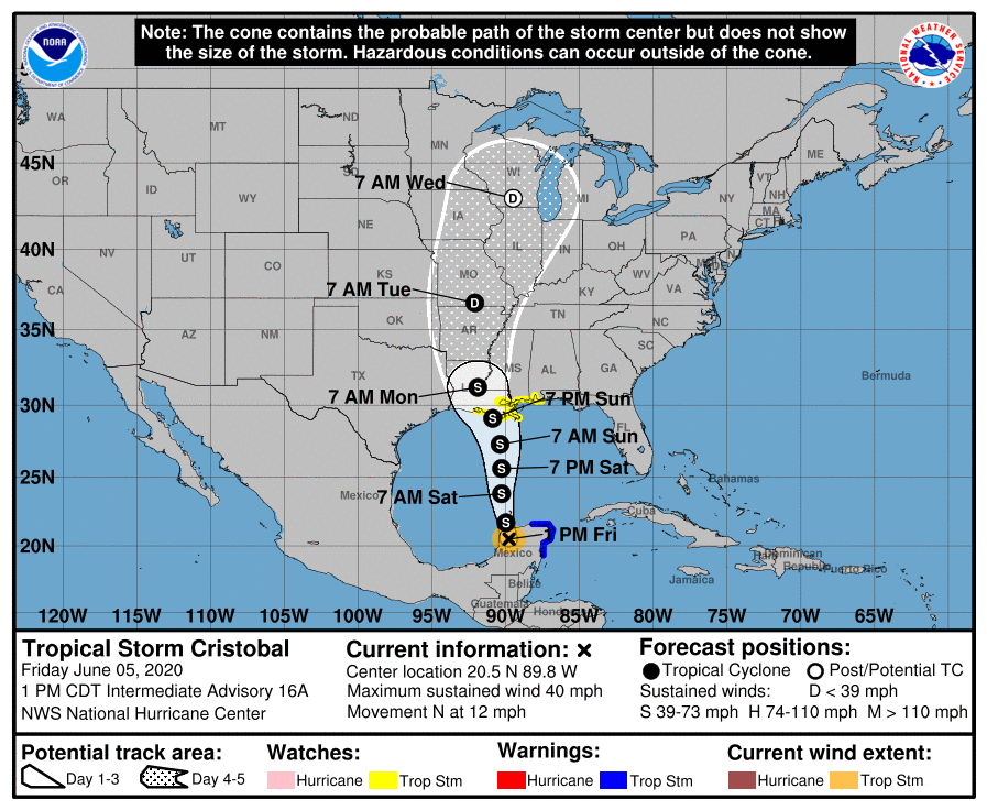
Tropical Storm Cristobal restrengthened from a tropical depression at around 1800 UTC on June 5. As of the latest estimates, Cristobal is producing maximum sustained winds of around 40 mph and a minimum central pressure of 1000 mbar, making it a minimal tropical storm. Over the past several days, Cristobal has dumped torrential rainfall over much of southern Mexico and parts of Central America, although the extent of the damage largely remains to be seen.

Over the next several days, Cristobal is expected to regain some of its former strength, although the amount of strengthening could be limited by the storm’s large size, dry air to its west and an increase in shear in the coming days. Despite this, Cristobal could still strengthen into a moderately strong tropical storm, and is predicted to make landfall over the Gulf Coast as a tropical storm- likely in Louisiana. After this time, Cristobal is expected to weaken as it moves north along the Mississippi Valley and dissipate over the Central or Midwestern US.
The majority of the threats that Cristobal now pose are still rainfall related, with totals of 4-8 inches expected in the Lower Mississippi Valley and Gulf Coast, with isolated amounts exceeding a foot possible. Areas in the mid-Mississippi valley are likely to see totals of 2-4 inches with maxima to 6 inches. In addition, Cristobal could deliver an additional 4-6 inches of rainfall to southern Mexico, including Campeche, coastal Chiapas, Oaxaca, Quintana Roo, Tabasco and Yucatan, as well as Belize, El Salvador and southern Guatemala. Southern Honduras may receive an additional 3-4 inches of rainfall. Storm surge will also become a threat as Cristobal approaches the Gulf Coast.
For the latest official information, please refer to the National Hurricane Center.
Force Thirteen also produces regular updates on their Twitter page and YouTube channel.
