Cyclone Damien Strengthening on Approach to the Pilbara Coast

Severe Tropical Cyclone is strengthening this morning on its approach to the Pilbara Coast in Western Australia. Hurricane-force winds, very heavy rainfall, and dangerous storm surge are expected throughout the day as Damien crosses the coast near Dampier this afternoon. Emergency preparations in the central Pilbara and northeastern Gascoyne regions should be rushed to completion as Damien makes its approach toward the coast this afternoon.
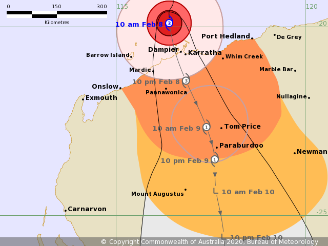
Current Storm Information
As of the most recent official posting from the Bureau of Meteorology (BOM) at 01:00 UTC Saturday, February 8, 2020, Severe Tropical Cyclone Damien is located within 20 km (10 mi) of 19.8°S, 116.4°E, about 115 km (70 mi) west-northwest of Karratha, and about 235 km (145 mi) west-northwest of Port Hedland. Damien is moving toward the south at 10 km/h (6 mph), and this motion is forecast to continue through today as Damien approaches the Pilbara coast. The cyclone is expected to cross the coast near Dampier this afternoon as a severe tropical cyclone and continue a generally southward motion through Monday. Maximum 10-minute sustained winds are 150 km/h (90 mph), and maximum 1-minute sustained winds are 155 km/h) (100 mph). As of 03:00 UTC, Force Thirteen estimates maximum sustained winds of 210 km/h (130 mph), and a minimum central pressure of 950 mb (28.05 inches). Damien is a Category 3 severe tropical cyclone on the Bureau of Meteorology’s tropical cyclone intensity scale, and a Category 4 tropical cyclone on the Saffir-Simpson scale per Force Thirteen estimates. Damien is expected to be a powerful and dangerous tropical cyclone when it crosses the coast later today. By Sunday, Damien is forecast to weaken to a Category 1 tropical cyclone as it moves inland, and degenerate into a low pressure system on Monday over the Mid West region.
Hazards Affecting Land
Gales are currently occuring along the central Pilbara coast between Roebourne and Cape Preston, including Karratha and Dampier, and are expected to extend to remaining areas along the Pilbara coast from Mardie to just west of Port Hedland this morning. Gales may also extend westward to Onslow later this morning. Destructive winds gusting to 150 km/h (90 mph) are expected between Roebourne and Cape Preston later this morning as the Damien approaches the coast. Very destructive winds gusting to 220 km/h (140 mph) are expected near the center of Damien later this morning as the cyclone makes landfall.
Dangerous storm surge, with tides expected to rise significantly above the normal high tide mark, are expected along the coast between Dampier and Whim Creek, including Dampier and Karratha. Storm surge is a leading cause of tropical cyclone-related destruction. Damaging surf and storm surge flooding is likely along the coast, which could cause significant damage to coastal structures. In addition, large swells are expected offshore in the vicinity of the tropical cyclone, which could produce dangerous conditions for mariners. Heavy rainfall is also expected in the Pilbara and Gascoyne regions through the weekend as Damien moves inland. Flood watches and warnings are currently in effect for these areas.
Recommended Action
The Department of Fire and Emergency Services (DFES) has issued a red community alert for residents in or near Whim Creek to Mardie, including Mardie, and south to Millstream, including Whim Creek, Point Samson, Cossack, Wickham, Roebourne, Karratha and Dampier. Those in the red alert area are advised to shelter immediately as Damien is approaching the coast. A yellow community alert has been issued for areas in or near Whim Creek, east to Yule River and south to Wittenoom, including Barrow Island and Pannawonica. Those in the yellow alert area are advised to prepare for dangerous weather conditions associated with Severe Tropical Cyclone Damien, and move to an appropriate shelter. Those in the blue alert area, including areas west of Mardie to Onslow, including Tom Price, Paraburdoo, and De Gray, are advised to prepare for dangerous weather conditions associated with Severe Tropical Cyclone Damien, and to organize an emergency kit. An emergency kit should include food and water, a torch, first aid, spare batteries, and a portable radio.
For more information regarding Severe Tropical Cyclone Damien, visit the Bureau of Meteorology on the web at http://www.bom.gov.au/, and refer to your local news and government outlets for the latest emergency information. Force Thirteen will be providing daily updates and live coverage on Damien through the weekend on the Force Thirteen YouTube page at https://www.youtube.com/user/Forcethirteen.
