Cyclone Emnati Skirts Mauritius and La Reunion, Chugs Towards Madagascar

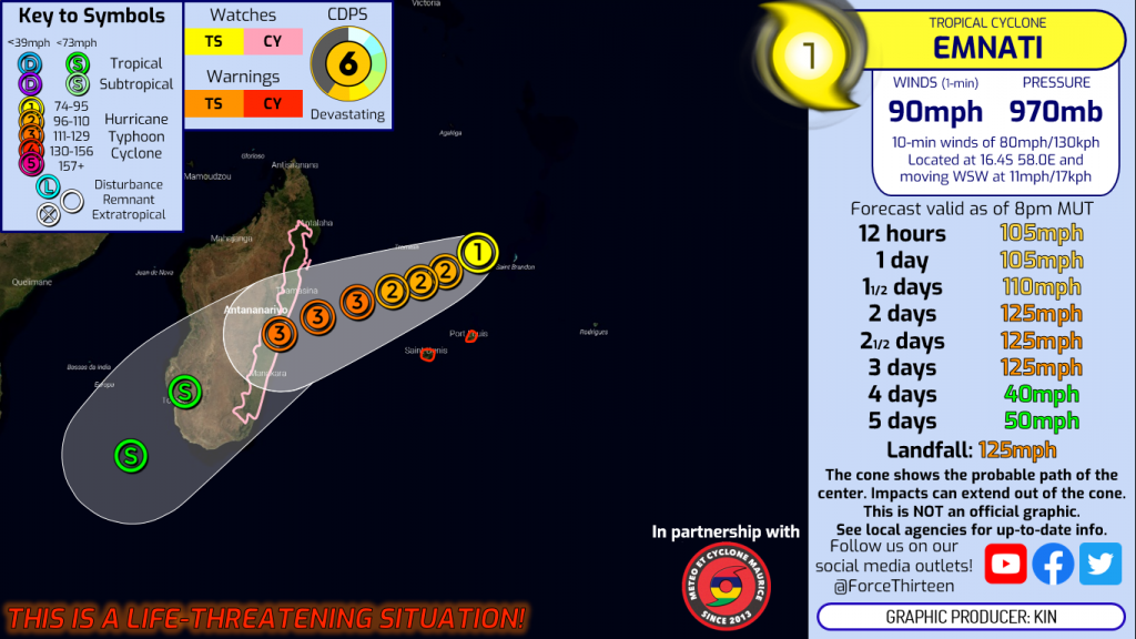
Madagascar’s woes with cyclones this year seem to get worse with the approach of Cyclone Emnati, the sixth named storm of the South Indian Ocean cyclone season in 2022. As of 18z on Saturday, February 19th, Cyclone Emnati was located at 16.9S, 57.2E or 354 km NNW of Port Louis, or 1195 ENE of Fenoarivo, Madagascar, moving SW at 9 mph, or 15 km/h. Emnati currently has winds of 90 mph, or 145 km/h. Cyclone Emnati poses a serious risk for portions of Eastern Madagascar, which were recently hit hard by Cyclone Batsirai which caused over 120 deaths in Madagascar alone, as well as displacing over 100,000 individuals, largely due to the severe flooding that the drenching rains brought to the region, a hazard which Emnati could pack as well. The current track has the storm generally impacting the same regions which were hit the hardest by Cyclone Batsirai, generating concern that the storm could cause a more significant crisis, enhanced by Tropical Storm Dumako’s landfall on the island which caused 14 deaths. However, the storm does look to be slightly weaker than Batsirai, but still poses a significant danger to the island of Madagascar. As of now, however, Cyclone Emnati poses the greatest risk to Mauritius and Reunion island, where the storm has been producing showery conditions.
Future Forecast
As mentioned, Cyclone Emnati is currently located just to the north of the Reunion islands, where cyclone warnings are in effect as the storm creates rough seas and squally weather. A class IV cyclone warning is in effect for the island of Mauritius, where a gust of 133 km/h was recorded in the town of Champ de Mars. In addition, a gust of 122 km/h was recorded in Nouvelle Decouverte. Currently, the greatest threat from Cyclone Emnati exists near Reunion and Mauritius islands, where said gusts have created significant threats to the island. However, the greatest threat in the coming days will be in Madagascar where the storm threatens to add to the damages caused by Batsirai and Dumako. Current forecasts call for the storm to intensify in the coming days where it could make landfall as a category 3 on the Saffir-Simpson Hurricane Scale and cause significant damages. Individuals in Eastern Madagascar should be beginning to complete preparations for the storm in the coming few days. Cyclone watches are currently in effect for much of Eastern Madagascar with the approach of Emnati, likely to turn into warnings as the storm draws closer. Current predictions have the storm moving past the French islands by Monday (or at least out of significant impacts) and landfall in Eastern Madagascar appears possible on Tuesday, however this timeframe could shift slightly, as well as the general forecast track in terms of landfall. As of now, the storm still appears likely to strike the Eastern Coast of Madagascar.
Stay updated with Cyclone Emnati and potential impacts by recieiving information from local Meteorological Offices, and stay tuned to Force Thirteen for more updates and information as the storm approaches Madagascar and leaves the Reunion islands. You can watch our latest video updates by visiting our Youtube page.
