Cyclone Niran Could Make a Life Threatening Landfall in 3-4 Days

Edited visible image of Cyclone Niran, courtesy of Force Thirteen Member Isaac G.
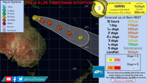
Cyclone Niran is currently at 90kts(165km/h) according to Force Thirteen and intensifying off of the Northeast Coast of Australia. Parts of the Australian coast are still experiencing adverse conditions, and Cyclone Warnings were only recently lifted. The JTWC expects a close pass by New Caledonia at an intensity of approximately 85kts(155km/h) on a 1 minute wind average, the BoM also expects Niran to pass by at 75kts(140km/h) on a 10 minute wind average, while F13 expects a landfall on New Caledonia at 100kts(185km/h) on a 1 minute wind average. All forecasts expect New Caledonia to at least experience adverse conditions and gale force winds. Force Thirteen’s forecast for Niran is perhaps the most troubling, making landfall on New Caledonia near Noumea at 160km/h on a ten minute average, Category 4 on the Australian tropical cyclone scale.
Recently, the cyclone seems to have started a phase of renewed intensification, which is reflected in the F13 forecast. Furthermore, the GFS model solution for Niran shows the cyclone making an incredibly close pass to New Caledonia, meaning that a high intensity landfall on the island is distinctly within the realm of possibility. Such a high intensity landfall is incredibly dangerous, and winds at this level make it impossible for a human being to remain upright without support. Remember that a Category 4 landfall is a life threatening situation, and winds can render large and dangerous debris airborne, while surf will be extremely high if the forecast verifies.
Niran is currently opening an eye and is developing quite quickly. On infrared imagery, the eye is quickly clearing within a healthy eyewall, while microwave imagery shows that the eyewall is consistent and strong down to the surface. Fast intensification is occurring as Niran opens its eye in a conducive environment, and its final intensity as it passes by or makes landfall in New Caledonia depends on how much it intensifies in the next 36 hours. Remember to check your local RSMC and local meteorological office for the most accurate information, and most importantly, stay safe in this possibly life threatening situation.
