Cyclone Vayu Continues its March North

Cyclone Vayu continues to churn in the northern Indian Ocean. While it has weakened substantially from its 110 mph peak in wind speed, the storm still has quite a bit of power, with strong winds, storm surge, and heavy rainfall still remaining threats with this storm.
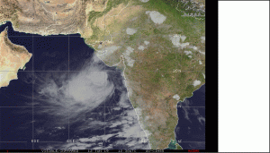
According to the Joint Typhoon Warning Center(JTWC), Vayu will make it’s closest approach to India within the next 36 hours as a Category 2 on the Saffir Simpson Hurricane Wind Scale. The storm is expected to have winds of 105mph or 90 knots at the time of landfall if it makes landfall. Whether the storm does make landfall or not, it does not change the fact that dry air will be creeping its way into the storm’s inflow, which will cause rapid weakening, and likely dissipation by the end of the 5 day forecast period.
Although the JTWC has made its forecast based on the factors described above, uncertainty still remains on the track and intensity of this system. The GEFS Ensembles below should give a good idea of just how much uncertainty there is

With that being said, due to the uncertainty associated with the track and intensity of this storm, anyone that could be within the track of this system in India, Pakistan, or Oman needs to be watching this closely, as Vayu still packs a punch.
