Cyclone Yaas continues to rise steadily, serious threats imminent in Odisha Region, India.

Yesterday, Yaas was expected to peak and make landfall as a 70kts category 1 cyclone as high wind shear unfavoured its development, Yaas continues to steadily intensify more than what was originally anticipated. Right now it still has around 12 hours for development before landfall and is already an 85mph cyclone, by Force Thirteen (F13) latest (23:30 IST) analysis. It is expected to move northwestward, with a projected landfall location between Bhadrak and Contai, Odisha region, which strong winds up to 180km/h and extensive flooding due to significant rainfall of over 400mm as main threats. Moreover, its area of influence is as large as 750km. Those under Yaas’ area of impact, especially in significant wind regions, should have finished preparation now as the destructive winds and rain are coming soon.
Current Storm Information
As of 18:00UTC (23:30IST), Force Thirteen has located Yaas at 20.3°N 87.7°E, with 1-minute sustained winds of 85mph (140km/h) and a pressure of 962mb, moving NW at 10mph (16km/h).
At the same time, the latest ATCF has Yaas as a category 1 cyclone in the SSHS. ATCF located it at 20.3°N 87.8°E, with winds of 75mph (120kph), and a pressure of 974mb.
While at 15:00UTC (20:30IST), according to the latest estimates from Indian Meteorological Department (IMD), they have Yaas located at 19.5°N 88.0°E, with 3-minute sustained winds of 120km/h (Very Severe Cyclonic Storm) and pressure of 974mb, and is moving NNW at 15km/h.
Developmental Process
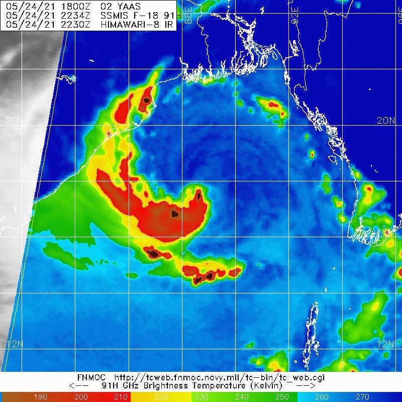
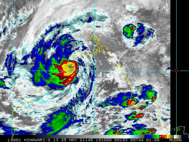
Yaas started as a large monsoon low that lacked organization, yet as models expected, tropical cyclogenesis underwent quickly and a well-defined circulation developed. However, as Yaas contracted and lost monsoonal characteristics as it developed under 31°C of the sea surface temperature, it became more prone to wind shear, thus the convection has been lopsided to the southwest, with the southern quadrant being the strongest. Though the infrared appearance has been quite poor due to 25kts of wind shear, observations by especially microwave imagery and Kolkata Buoy (17.9°N 89.2°E) have revealed that Yaas, instead of holding intensity, has been improving constantly still. From 36GHz-H AMSR2 Microwave imagery at 07:12UTC, it showed a rather solid lower-level core. In addition, with the aid of Kolkata Buoy pressure data, it showed that the central pressure of Yaas has been decreasing at a rate of roughly a millibar per hour, as it recorded a minimum pressure of 976mb at 05:30IST.
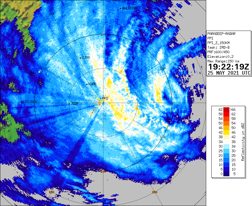
In recent hours, as Yaas has entered the range of Paradip radar, a rapidly developing eyewall is also observed with a Doppler radial velocity of at least 38m/s at 350m elevation. Radar also reflects that Yaas is attempting to repair the eastern side that suffered from high wind shear earlier. What is more, a very strong hot tower firing upshear with cloud tops temperature near -90°C signifies more intensification as it approaches closer to an upper-level anticyclone (ULAC) where shear weakens. The latest (17:30IST) Subjective Dvorak estimate by IMD also concluded a final T number of 4.0 (65kts) with an increasing trend, as well as a likeliness of some underestimation as surface pressure observation from Kolkata Buoy and microwave may indicate higher winds than what Dvorak Technique suggests. The isobar map of Hong Kong Observatory indicated a radius of closed isobar of at least 900km, not to mention the average gale wind radius of around 300km derived by ASCAT, which showed the huge influence of Yaas due to its monsoonal nature. The increasing intensification trend is triggered by two factors. The first one is because of weakening wind shear to 20kts, as well as improving the upper-level divergence, and the second one is because the frictional convergence starts to induce more convection as it is off the coast of Odisha, such that more convection favors intensification near land.
Current surface reports
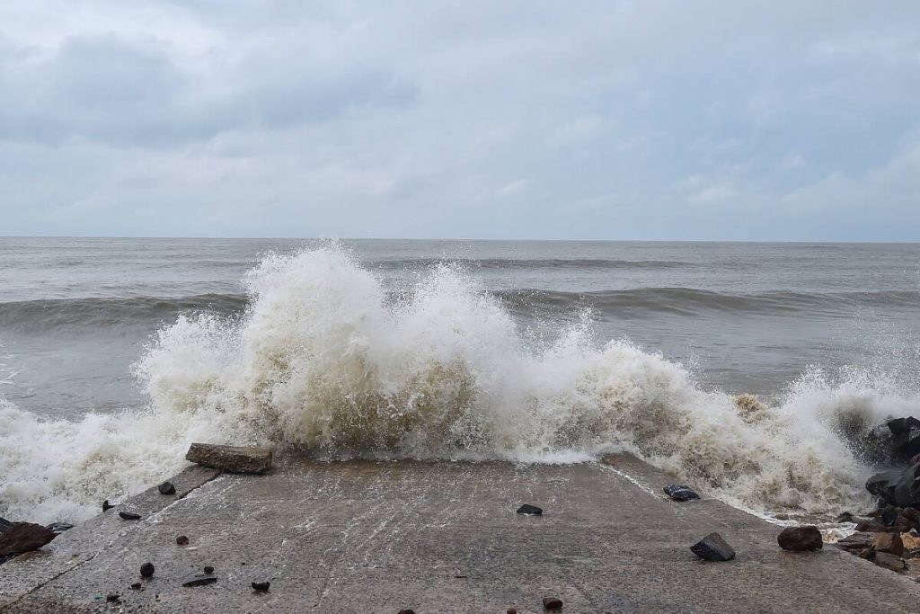
Many sources have reported a turbulent sea with waves over 1m brushing the coastline. The wave height will increase exponentially as Yaas continues approaching. In West Bengal least 40 houses were damaged in Halisahar and Chuchura respectively, with 5 people injured. Two unfortunately died due to lightning strikes in Chinsurah that come from a rare damaging tornado there.
Current Warnings, Preparations Done.
To start with, the Chief Minister of Odisha, Naveen Patnaik urged the residents of coastal regions to cooperate with local administration and shift to cyclone shelters, as well as maintain the COVID-19 protocols and wear masks. So far at least 300,000 residents in Odisha have been deployed, as well as fishermen and ships have also been taken to shelters due to strong waves and the water level rise due to torrential rain, storm surge, and tidal waves.
India’s navy and air force are also on standby to effectuate the relief and rescue work, along with 149 teams deployed by the National Disaster Response Force (NDRF) in 5 states, mostly to West Bengal and Odisha, with a total of 99 teams on the ground. Apart from institutional teams posited under high alert of Yaas, Municipal Corporation in Calcutta and Bidhannagar has deployed teams comprising personnel from civic bodies, police, and the power utility to utilize the efficiency of the preparation and the relief work such as restoring power, removing fallen trees.
Here are the summarized reminders when a storm approaches:
1. Please stay in a reasonably protected place indoors. Evacuate from the coast as urged. STOP all water and fishing activities due to the turbulent sea.
2. Do NOT stand beside trees, power lines, and exposed windows as they will easily fall and break which imposes life-threatening danger. Stay in the interior of the room. Beware of flying debris.
3. Storm surge up to 4m and heavy rainfall will cause serious flooding in low-lying areas especially near the delta region. Evacuate to higher indoor places.
4. If the eye directly passes above you, the winds and rain will be calm for some time. However, do NOT be caught off guard, as the strongest winds and rain from the backside of the vortex will suddenly blow from another direction.
5. After the passage of the storm, the possibility of danger will continue. Please remain alert for your safety.
Forecast Track
As a consequence of continuously improving environments such as weakening shear, better divergence, and frictional convergence, it is forecast to keep strengthening all the way until landfall after 6 to 12 hours. Therefore, Force Thirteen has forecast a 90mph peak and make landfall at peak. To reiterate, the projected landfall location is between Bhadrak and Contai, Odisha region, with a high consensus of model support. The landfalling regions are expected to suffer winds up to 180km/h and at least 400mm of rainfall, along with a storm surge of around 4 meters, while the area within a 300km radius from its center will also suffer from at least 100mm of rainfall and destructive gale or storm force winds.
After Yaas make landfall, land interaction will cause significant weakening and the system is expected to dissipate over the next two days. Nevertheless, rainfall threat from the remnants of Yaas is expected to persist until the end of May.
Please finish your preparations now as the storm is arriving within 12 hours. Stay tuned to official warnings and advisories, as well as Force Thirteen videos, and graphical and live updates on our Twitter. Stay safe.
Sources:
https://mausam.imd.gov.in/imd_latest/contents/cyclone.php#.
https://www.hindustantimes.com/cities/kolkata-news/two-electrocuted-40-houses-partly-damaged-in-tornado-ahead-of-yaas-mamata-101621951493381.html
https://www.telegraphindia.com/west-bengal/calcutta/how-calcutta-is-preparing-for-cyclone-yaas/cid/1816654
https://opinionexpress.in/odisha-cm-urges-people-on-coasts-to-shift-to-cyclone-shelters
https://timesofindia.indiatimes.com/city/kolkata/cyclone-yaas-live-updates-yaas-intensifies-into-cyclonic-storm/liveblog/82873733.cms
https://www.financialexpress.com/lifestyle/science/yaas-cyclone-yaas-live-updates-cyclone-yaas-live-may-25-odisha-paradip-balasore-puru-bhubaneswar-west-bengal-kolkata-sagar-island-imd-cyclone-weather-live/2257981/
