Cyclonic Storm Vayu forms in the Arabian Sea, Threat to India, Pakistan Increasing

The disturbance which the India Meteorological Department (IMD) and the Joint Typhoon Warning Center (JTWC) have been monitoring, labeled 93A, for the past few days, has developed into a tropical cyclone. The IMD assigned the cyclone the name Vayu, which was the next name on its lists awaiting usage. As of the IMD’s latest bulletin, Vayu was centered at 13.9°N, 70.6°E at 23:30 Indian Standard Time (IMD), or 18:00 Coordinated Universal Time (UTC), or about 236 mi (380 km) northwest of Aminidivi, and was moving north-northwestward at 7.45 mph (12 km/h). Maximum 3-minute sustained winds were 35 kt (40 mph), while maximum 1-minute sustained winds were 45 kt (50 mph). The minimum barometric pressure was 992 millibars (29.29 inches). Vayu is forecast to strengthen into a Severe Cyclonic Storm during the next 24 hours as it continues a northward motion, crossing the Gujarat coast between Porbandar and Mahuva near the Veraval & Diu region as a Severe Cyclonic Storm with maximum sustained wind speeds at 70 to 75 mph (110 to 120 km/h), followed by rapid weakening into a depression as it moves inland.
Threats at Hand
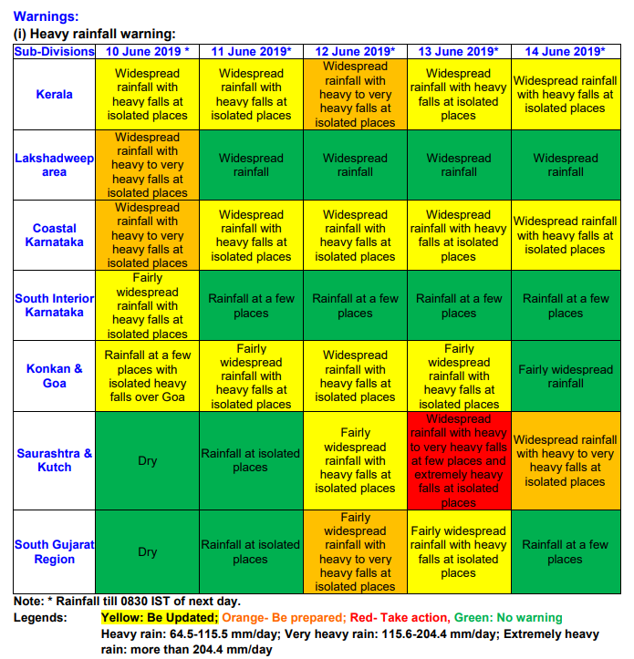
Vayu is expected to bring strong winds increasing to gale-force, and possibly hurricane-force, as well as widespread heavy rainfall to northwestern India. Rainfall rates could exceed 8.05 in (204.5 mm) per day in certain areas of Gujarat. The heaviest rainfall threat will occur from June 10 to 11 for the southwest Indian coast, and from June 13 to 14 for areas further north. This heavy rainfall could cause life-threatening flash floods and mud slides across western India and into southern Pakistan. As Vayu is forecast to remain very close to the coast, rough seas and swells are likely to affect large portions of the coastline, which could prove hazardous to boaters. Boaters and fishermen are advised not to venture into the Arabian Sea, as strong winds and high swells may damage or overturn vessels. In addition to heavy rainfall and large swells, strong winds are likely to affect Gujarat state in India, where Vayu is forecast to make landfall. Gale-force winds are forecast to arrive on the Gujarat coast by June 12, increasing to near hurricane-force in the morning hours of June 13, and gradually decreasing thereafter as the cyclone progresses further inland. Although winds will decrease as Vayu moves inland, gale-force winds are still likely in the Sindh province of Pakistan, in addition to the heavy rainfall potential, which is likely to persist even as the cyclone weakens. Residents in this region are advised to remain ready and alert, and closely monitor this developing tropical cyclone threat.
Further information on Vayu and its potential impacts in India and Pakistan can be found on Force Thirteen’s outlets. These include its official Facebook and Twitter accounts, as well as its YouTube Channel, where live updates can be found regarding Vayu and areas at risk.
