Dangerous Severe Weather and Rainfall Event Developing in the Southeast

A large and strengthening storm complex is forecast to bring hazardous weather conditions across much of the Central and Eastern United States this week. In the Southeast, a multi-day severe weather and rainfall event is unfolding. Severe thunderstorms will bring a risk of damaging winds and tornadoes, while heavy rainfall is forecast across much of the region. North of the storm track, a band of snow and ice will bring hazardous travel conditions from north-central Texas into the Midwest and Northeast.
Southeast: Severe Weather and Rainfall Event
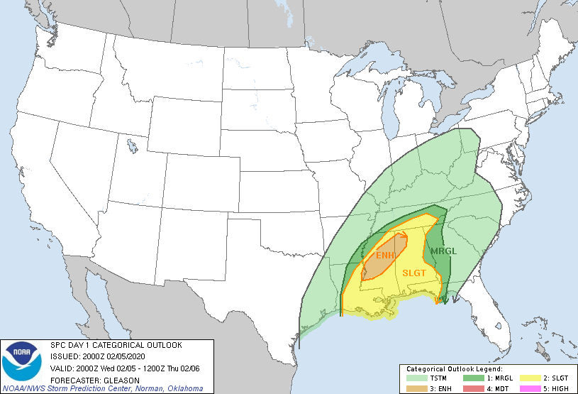
South of the track of the low pressure system, heavy rainfall is the primary threat from this system. A multi-day severe weather event is also unfolding across the Gulf Coast and lower Mississippi Valley. Severe thunderstorms will be capable of producing damaging winds, large hail, and tornadoes, some of which could be strong and long-tracked. The greatest risk for severe weather today is across portions of central Mississippi and northern Alabama. The Weather Prediction Center (WPC) has declared an enhanced risk for severe thunderstorms in this area. A slight risk for severe thunderstorms exists from southern Louisiana into the Florida panhandle and southern Tennessee. The marginal risk area extends into western Georgia and extreme southwestern North Carolina. In the risk area, severe thunderstorms capable of producing all kinds of severe weather are possible. On Thursday, the severe weather threat shifts eastward, with an enhanced risk extending from the Florida panhandle and Big Bend region into central North Carolina, the slight risk area extending from eastern Alabama into southeastern Virginia, and the marginal risk area extending from southern Alabama into southern Maryland. The primary risk for Thursday will be damaging winds, although a few isolated tornadoes are possible within the enhanced and slight risk zones.
Through Friday, heavy rainfall can be expected across much of the Southeast as well as portions of the coastal Northeast. Flood watches are currently in effect from the southern Gulf Coast northeastward into southern New Jersey. An extended period of heavy rainfall associated with this large storm complex will lead to conditions favorable for flooding. Rainfall totals will vary with location, but total rain accumulations of 2 inches or more can be expected in and near the flood watch zone. Rapid rise of streams, creeks, and rivers is possible in addition to roadway flooding. Flash flooding is also possible where rainfall rates are forecast to be greater. Flash flooding is a dangerous situation; do not attempt to drive through flooded areas.
External Links
For further information on the dangerous weather situation this week, refer to your local National Weather Service forecast office. Information from NWS forecast offices can be retrieved online at www.weather.gov. Force Thirteen will also be providing coverage on this week’s weather event on the Force Thirteen US YouTube channel, if conditions warrant.
