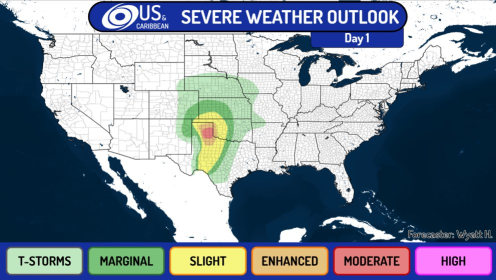
Dangerous Severe Weather Threat for the United States as The SPC issues a Moderate Risk

As the storm prediction center have issued a Significant Risk for Tornadoes, severe weather, wind, hail and rain, the HRRR forecasts the possibility of strong isolated supercells which can produce strong long-lived tornadoes. In this article we’ll be discussing the risks and possibilities. A Severe Threat has been issued aswell.
The Severe Weather Set-up
The oncoming outbreak threat is driven by a large trough, which transports warm moist air from the Gulf of Mexico upwards throughout Texas, New Mexico, Western Oklahoma and the rest of the midwest. As the trough moves towards the midwestern and eastern United States, it deepens and undergoes cyclogenesis. This creates a very favourable warm sector, which then creates an environment that can support strong, long-lived tornadoes and large hail. As the dry-line passes, it will be the initatior for the thunderstorms and severe weather event. Theta-E charts from GFSv16 and supercell composites show a very dangerous situation coming up. In the area of Oklahoma, the clouddeck is likely clear enough to allow for more surface heating, which leads to a quicker destabilization. A more instable environment for tornadic and possibly cyclic supercells will be built up. Later in the afternoon, the cells are forecasted to spring up and organise quickly. Observed Soundings show a potentially dangerous situation for many areas. There is a hatched moderate risk for tornadoes in place for the Texas Panhandle. As supercells are starting to fire up. The risk of a dangerous outbreak increases. The first PDS cell could form within the next hours.

i expect tornado