Dangerous Tropical Storm Barry Still Strengthening; Conditions Deteriorating along the Louisiana Coast

Despite exhibiting a rather unusual structure during the last couple of days, Tropical Storm Barry has continued to intensify, and is now near hurricane-strength as it approaches the central Louisiana coast. As of the National Hurricane Center’s most recent advisory at 10:00 PM CDT (03:00 UTC), the center of Tropical Storm Barry was located near 28.6°N, 91.0°W, about 75 mi (125 km) south of Morgan City, Louisiana, or about 120 mi (195 km) west-southwest of the mouth of the Mississippi River. Barry had maximum sustained winds of 65 mph (100 km/h), with gusts to 75 mph (120 km/h), and the minimum central pressure was 993 mb (29.33 inches). The cyclone was moving west-northwestward at 3 mph (5 km/h), and it is anticipated to turn northwestward, making landfall on the central Louisiana coast this morning. Afterward, Barry should weaken and turn northward, then northeastward as it moves inland, becoming extratropical by Monday. Tropical storm-force winds extend outward up to 175 miles (280 km) from the center of Barry. The NHC forecasts the cyclone to continue strengthening up to the point of landfall, and Barry is expected to be a hurricane when it makes landfall on the Louisiana coast.
Landfall Timing and Location
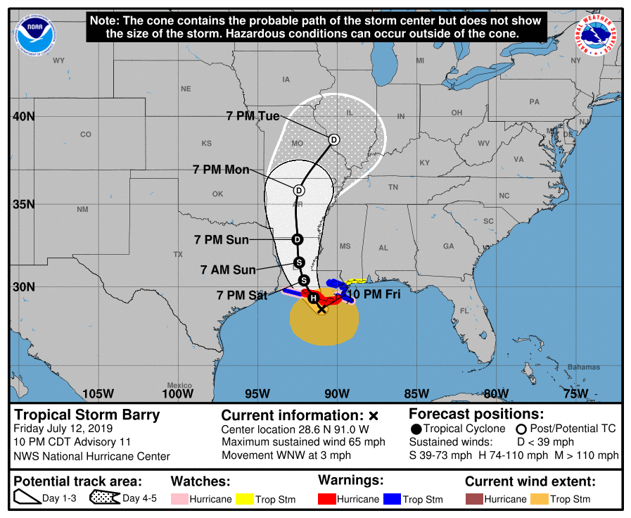
While Barry is expected to make landfall on the Louisiana coast as a hurricane this morning, the exact timing and location of its landfall is not yet certain. Recently, Barry has slowed slightly in forward speed, which could delay the timing of its landfall, and may also allocate more time for the cyclone to intensify. The exact landfall location will most likely be determined by the timing at which Barry begins its northward turn, which is expected to occur this morning as the cyclone nears the coast. The current forecast cone from the National Hurricane Center shows Barry moving into the Atchafalaya Bay and making landfall in western Saint Mary county. This forecast lies in the middle of the model guidance, which is now tightly clustered as Barry is now close to the coast. Regardless of exactly when and where Barry makes landfall, life-threatening flooding from storm surge and heavy rainfall is expected across much of Louisiana and southwestern Mississippi.
Impact and Areas at Risk
Barry is a very dangerous tropical cyclone, and is expected to bring life-threatening floods to much of the Mississippi Valley. The primary threats are heavy rainfall and storm surge. Specifics on the severity, location, and timing of these threats are presented below.
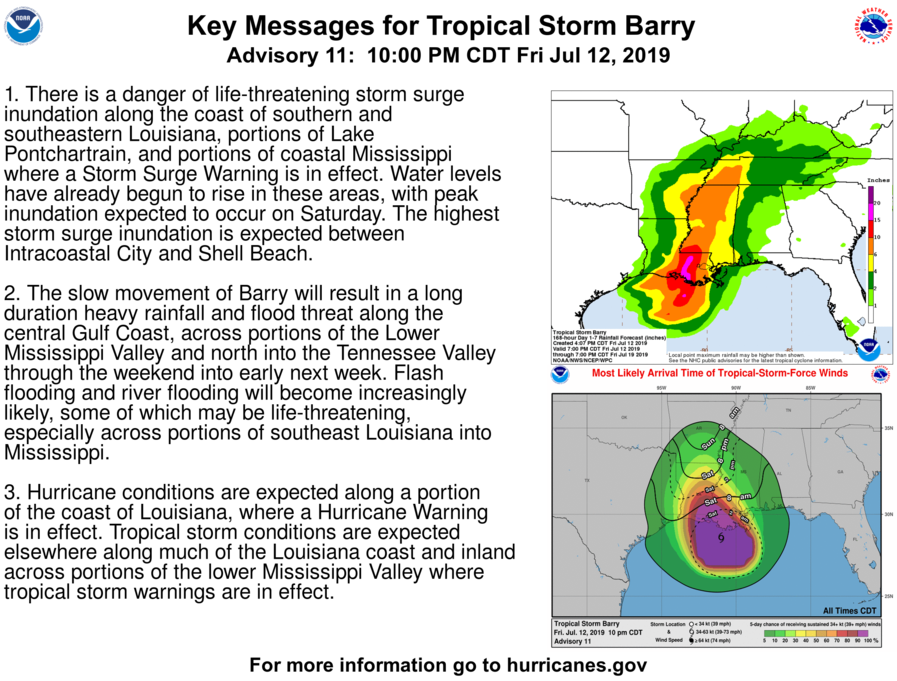
The highest rainfall totals from Barry are expected to occur to the east of where the center is expected to make landfall. Total rain accumulations of 10 to 15 inches are expected across southeastern Louisiana and into southwestern Mississippi, with locally higher amounts which could exceed 20 inches possible. Rainfall accumulations of 6 to 8 inches are likely northward into southwestern Tennessee, while lighter accumulations are expected elsewhere in the Southeastern and Midwestern United States. This heavy rainfall could cause many rivers, streams, and lakes to exceed their banks, which could inundate nearby structures. Locations along the Mississippi river in particular should be attentive to the situation. Major flooding of areas along the river is forecast due to the anticipated heavy rainfall that Barry is expected to produce. Flooding is one of the leading causes of damage and deaths from tropical cyclones. Never attempt to walk or drive into a flooded area, the water may be much deeper than it appears. If flash flooding is occurring, move to higher ground and stay away from the flooded area. Ensure that you have taken proper precautionary measures and have an emergency plan in action in case basic utilities become inaccessible.
Barry also poses a danger of life-threatening storm surge inundation along the Louisiana and Mississippi coasts. Storm surge inundation of greater than three feet is forecast along much of the central and eastern Louisiana coast, as well as portions of the Mississippi coast. The highest storm surge inundation is expected between Intracoastal City and Shell Beach, where up to six feet of inundation is possible. Storm surge is often the greatest threat to life and property to areas along the coastline. Storm surge can cause severe beach erosion and can cause significant damage to structures near the coast from wave action and rapidly-rising seawater. If you live in a coastal area and have not evacuated, there is very little time left to do so. Move to the highest floor of your home and take precautionary measures, if possible, to protect your home from storm surge.
Please refer to the National Hurricane Center and National Weather Service websites for further information regarding Tropical Storm Barry as well as watches and warnings in effect. Force Thirteen will be providing daily coverage on Tropical Storm Barry. Live updates and Tropical Weather Bulletins can be found at the Force Thirteen YouTube channel. More information can be found at Force Thirteen’s Twitter and Facebook pages.
