Depression Becomes Tropical Storm Arthur off the Florida Coast; Forecast to Impact North Carolina and the Mid-Atlantic Coast

Tropical Depression One, which developed off the east coast of Florida on Saturday, has strengthened into Tropical Storm Arthur based on data from an Air Force reconnaissance aircraft. As of the most recent advisory from the National Hurricane Center (NHC) at 11:00 PM EDT (03:00 UTC), the center of Tropical Storm Arthur was located near 29.4°N, 77.7°W, about 190 mi (305 km) east-southeast of Cape Canaveral, Florida, and about 420 mi (675 km) south-southwest of Cape Hatteras, North Carolina. Maximum sustained winds have increased to 40 mph (65 km/h) with gusts to 50 mph (85 km/h), and the minimum central pressure is 1006 mb (29.71 inches). The cyclone is moving north-northeastward at around 13 mph (20 km/h), and this motion is expected to continue through Sunday. A faster northeastward motion is expected to begin on Monday, and Arthur will be moving near the coast of North Carolina around that time. Tropical storm-force winds extend outward up to 80 miles (130 km) from the center of Arthur. The NHC anticipates some additional strengthening within the next 48 hours as Arthur moves northeastward, and the storm could pass near the coast of North Carolina as a moderately strong tropical storm.
Forecast Track and Intensity Guidance
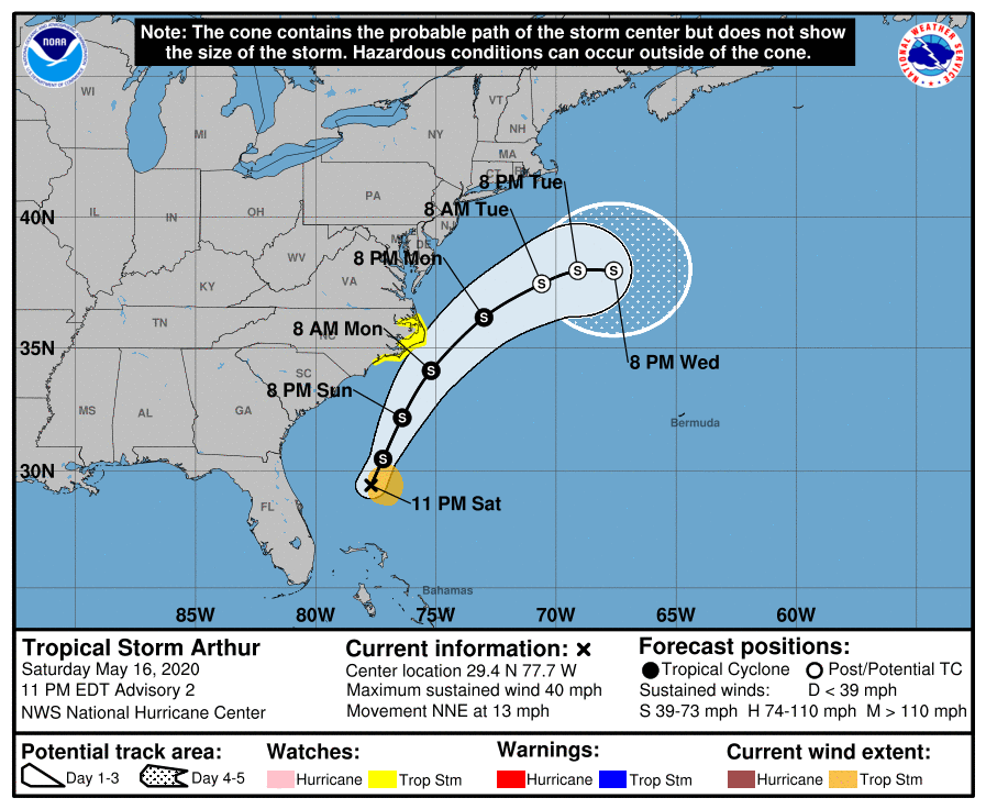
While Numerical Weather Models generally agree on Tropical Storm Arthur taking a generally northeastward to north-northeastward track, there is considerable model divergence regarding how close Arthur will pass to the East Coast of the United States. A sharp shortwave trough currently moving across the central United States is forecast to dig east-southeast to southeastward over the next 48 hours, and will have major implications on the track of Arthur. The further south the shortwave trough digs across the southeastern United States, the closer Arthur could be pulled westward toward the coast of North Carolina, as indicated by the GFS and HWRF scenarios. In contrast, the ECMWF and UKMET scenarios show the trough weakening and quickly lifting out, allowing Arthur to escape eastward and away from the East Coast of the United States. For now, the NHC track forecast splits the difference between the two scenarios and closely follows the consensus models, which are roughly midway between the two solutions.
Arthur is currently situated over cooler shelf waters near the coast of the United States, which should prevent any significant strengthening in the near term. By Monday, however, the cyclone will be moving over the warm waters of the Gulf Stream, which should allow for some strengthening as it approaches the Outer Banks of North Carolina. All models generally show at least modes strengthening, and the most recent NHC intensity forecast brings Arthur to a peak intensity of 60 mph (95 km/h) by the time it is shown to become extratropical on Tuesday morning. Model guidance is generally in good agreement of the magnitude of intensification, although if Arthur takes a track further away from the coast, it will likely have more time to strengthen over the warm Gulf Stream. Much cooler waters which lie just north of the Gulf Stream will likely bring about extratropical transition by Tuesday.
Impact and Areas at Risk
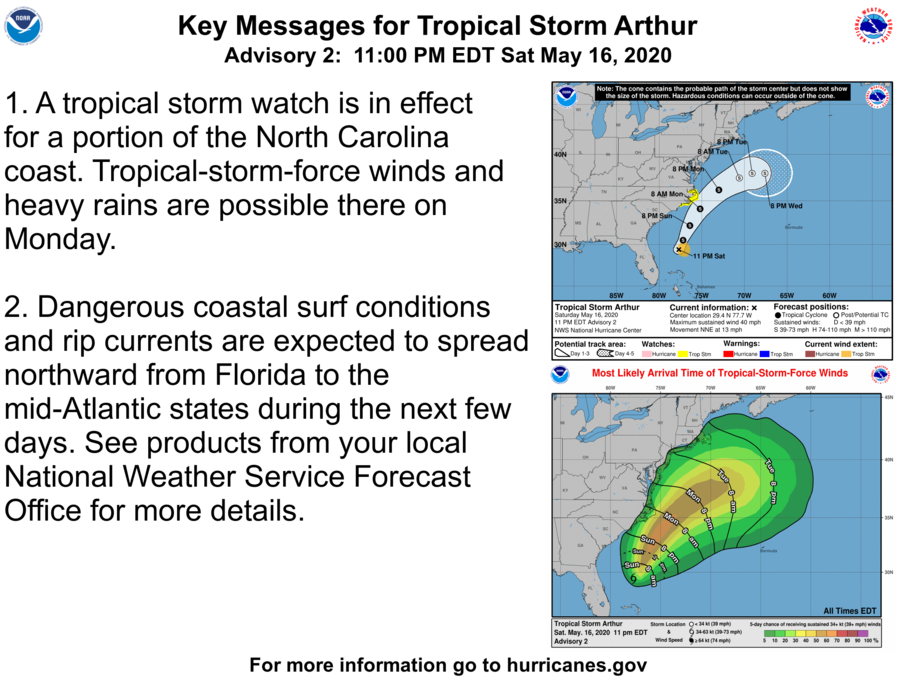
Although it is still uncertain how close Arthur may get to the East Coast of the United States, residents on and near the coast of North Carolina, the Delmarva Peninsula, and northward into New Jersey and the Northeast coast should closely monitor the progress of Arthur. A tropical storm watch is currently in effect for a portion of the North Carolina coast from Surf City northward to Duck, including the Pamlico and Albemarle Sounds. Tropical storm-force winds and heavy rainfall are possible in the watch area on Monday. Tropical storm conditions could also occur northward along the coasts of Virginia, Maryland, and Delaware, as well as New Jersey, if the storm takes a track closer to the coast. Arthur is also expected to produce total rainfall accumulations of 1 to 2 inches over coastal North Carolina Sunday night and Monday. Dangerous coastal surf conditions and rip currents are forecast to spread northward from Florida into Georgia, the Carolinas, and the Delmarva Peninsula during the next few days. These large swells and rip current conditions may prove hazardous to mariners and those on the shore. Please refer to the National Hurricane Center and your local National Weather Service office for further information regarding Tropical Storm Arthur.
External Links
Please refer to the National Hurricane Center and National Weather Service websites for further information regarding Tropical Storm Arthur as well as watches and warnings in effect. Force Thirteen will be providing daily coverage on Tropical Storm Arthur beginning Sunday, and will be providing coverage as conditions warrant. More information can be found at Force Thirteen’s official outlooks, including its Twitter and Facebook pages.
