Dorian Becomes a Powerful Hurricane; Forecast Starting to Shift for the United States

This article is provided by Hank Dolce, and is transcribed from his site. The original article can be found here: https://tropicstopics.com/2019/08/31/dorian-becomes-a-powerful-hurricane-forecast-starting-to-shift-for-the-united-states/
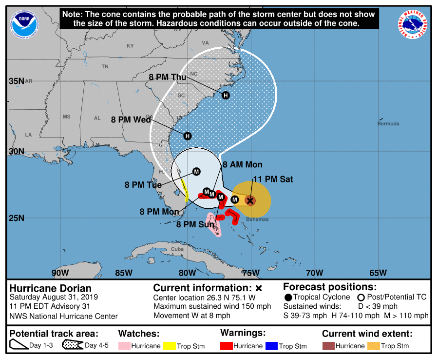
Since we last spoke, Hurricane Dorian has become a monstrous category 4 hurricane north of the Bahamas. It’s packing winds of 150mph and a pressure of around 945mb. It has made it’s all-important westerly turn and has begun slowing down in forward speed. Hurricane Warnings are up for the Northwestern Bahamas, who could see a historic impact from Dorian. As for the United States, the track forecast has shifted away from Florida, but we’ll discuss that more in-depth later.
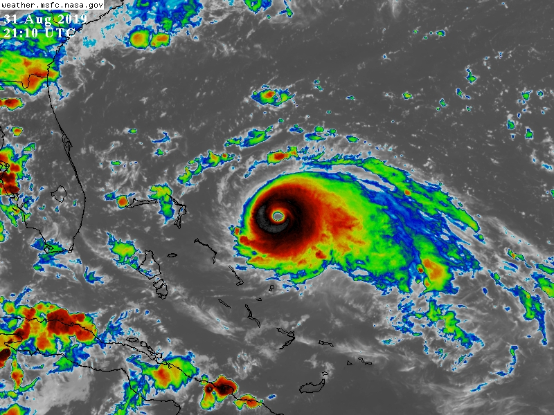
Aircraft Reconnaissance has been flying into the storm nonstop for the past several days, and last night found a rapidly intensifying major hurricane. The central pressure dropped 22mb and winds increased 25mph in 6 hours yesterday evening. The storm has since leveled off once more, as the inner core seems to be undergoing some adjustments. The Air Force mission from earlier today showed the pressure steady in the mid-940mb range with a slight northward jog. Radar imagery from reconnaissance flights suggested that the storm was trying to close off a secondary eyewall, which would’ve been a decent indicator of the onset of an eyewall replacement cycle. However, recent imagery has shown that the cloud tops continue to cool and the eye remaining extremely clear. The CDO remains relatively uniform and less asymmetric, with patches of -70C tops on either side of the eye, which has even been shrinking in recent frames. Dorian is also smaller than most Atlantic hurricanes of its caliber, meaning that it is more susceptible to extreme intensity fluctuations, both up and down. It is possible that Dorian strengthens further to become an elusive category 5 hurricane later today or tonight, and a new mission is inbound to find out exactly how strong the storm is.

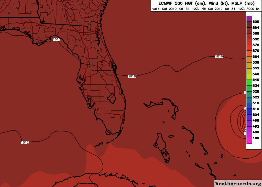
Conditions will remain favorable for Dorian to keep its incredible intensity for the rest of the weekend, but internal inhibitors, such as eyewall replacement cycles, may hinder it from getting that much stronger than what it is right now. However, the forward movement of the storm is absolutely crucial for the forecast track. The storm is currently moving west, specifically at 280 degrees (slightly north of due west), at about 8mph. This is important because the storm is forecast to stall a little bit sooner due to its slower movement than what was initially forecast. Dorian will continue moving westward under the influence of the ridge to the north, directly towards the islands of Great Abaco and Grand Bahama in the northwestern Bahamas. Once the hurricane reaches these islands, opposing steering currents will cause the storm to stall. Dorian will run into a ridge over the northeastern Gulf of Mexico, which will act to compete against the ridge to its northeast as the dominant steering flow in differing heights. This will cause the storm to stall over the northwestern Bahamas for possibly over a day as a powerful category 4 or even 5 hurricane, which is potentially catastrophic. The storm may even take a southward dip in the Bahamas depending on how strong the Gulf ridge is.
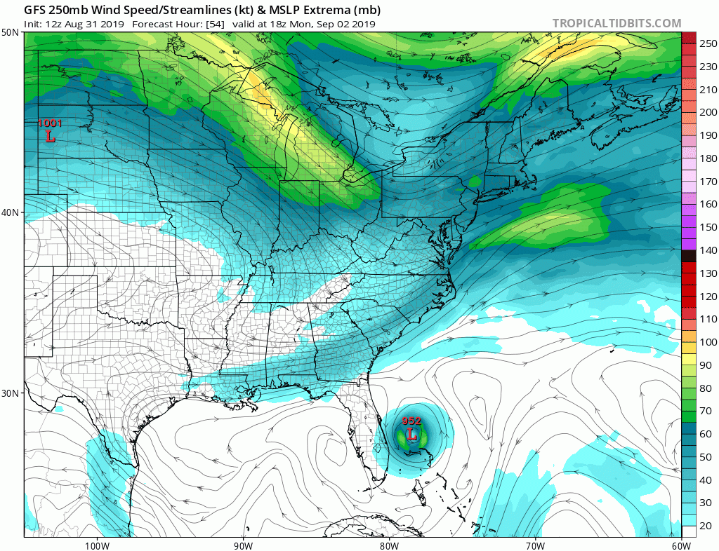
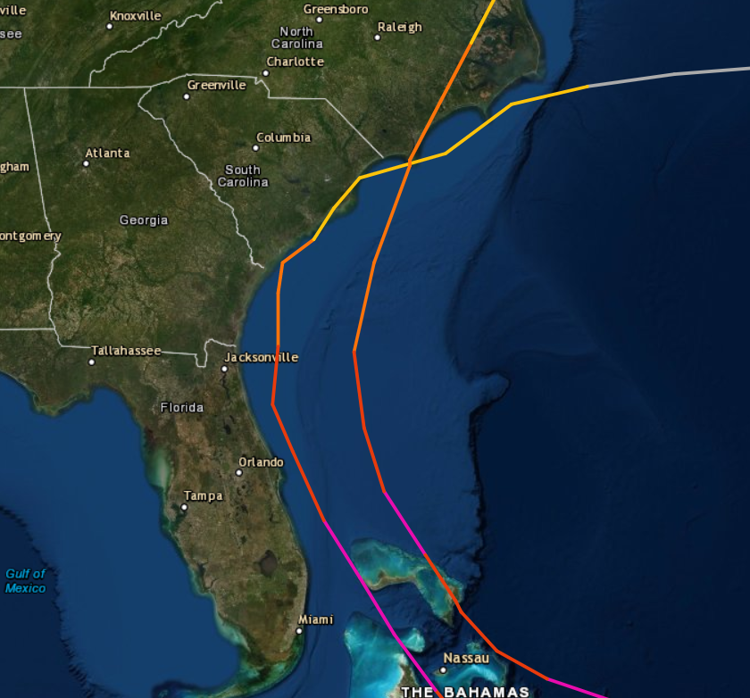
After this point, Dorian is going to make a turn towards the north, but it now appears as if this turn will take place offshore of Florida. Because of the delayed motion, a trough moving over the Northeast will act to break down the Gulf ridge and pull the storm northwards. It should continue a due north motion until it starts to approach the coast of South Carolina by the middle of the week, where a second trough will track across the Great Lakes and act to push Dorian northeastwards either along or just offshore. Given these solutions, it’s entirely possible that Dorian might not make landfall in the U.S. at all, but model uncertainty is still high given the range of the forecast. The hurricane then should exit the region by the end of the week and shoot off into the open Atlantic.
While some of this may been seen as good news to some, it is important to remain vigilant regardless of short-term trends. These models tend to shift frequently, and a shift back towards the Florida coastline is certainly possible if either Dorian speeds up or if the trough weakens. Models have struggled with Dorian’s initialization thus far as well, generating it much weaker than in reality, though this may be due to its small size. What this means is that the handling of the hurricane is not quite as great as normal, so keep a weary eye just in case they trend back towards land. A recent comparison to Dorian’s potential impacts can be drawn back to Matthew of 2016, which tracked just off the coastline and only made a brief landfall in South Carolina as a weakened category 1 hurricane. The storm still caused $3 billion in damages in Florida despite its eyewall only making contact with Cape Canaveral and the center remaining 20mi offshore. It was then a flooding disaster in the Carolinas akin to Hurricane Floyd of 1999, another storm that is taking a track similar to Dorian.
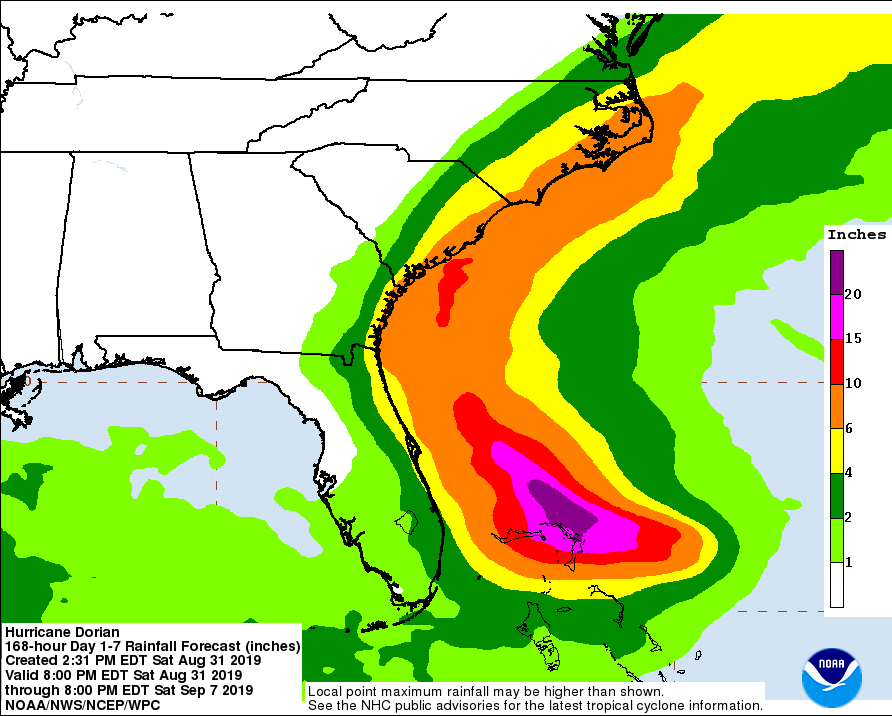
Dorian is still expected to bring serious impacts to the U.S. and especially to the Bahamas, where storm surge flooding up to and over 12′ may occur. Hurricane Warnings are in effect for those islands as well as a Hurricane Watch for Most importantly though, due to the slow motion of the storm, rainfall could bring disastrous flooding, possibly up to or over 2′. Winds over 120mph are all but given for the islands, which will cause extreme damage to structures, some could be obliterated entirely if Dorian makes landfall at its current strength. For U.S. residents, remember that a hurricane does not need to make landfall to still cause serious problems. While Matthew never made landfall in Florida, it still brought dangerous coastal flooding and beach erosion from storm surge as well as high winds and heavy rains. Dorian may not quite approach the coast as close as Matthew did (although models may shift west again, like stated previously), but still expect coastal flooding, beach erosion, wind damage, and heavy rainfall along the east coast of Florida. Tropical Storm Watches have gone into effect for portions of the coastline. The threat has increased for states further north, such as Georgia, South Carolina, North Carolina, and even Virginia. While landfall remains uncertain and Dorian should be weaker as it approaches, that should not be the primary focus of your decisions. Heavy, possibly flooding rainfall could occur along the coasts and further inland as well as winds strong enough to knock out power, take down trees, and cause widespread problems.
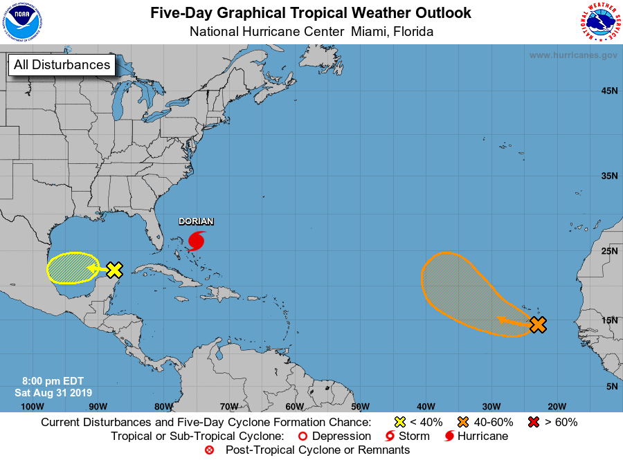
There are also 2 other areas of interest in the remainder of the Atlantic now. One of which, a disturbance located just north of the Yucatan Peninsula, has a 30% chance of forming into a tropical depression in the next 5 days. It will gradually traverse west under a ridge in the NE Gulf, the same slowing Dorian’s motion, and it could have a brief shot to develop near the Mexican coastline. Model support is not particularly high, but it’s worth monitoring nonetheless. Another disturbance, a tropical wave southeast of the Cabo Verde Islands, has a better, 60%, chance of development as it tracks northwest. Model guidance tracks it northwest past the islands, with most forming it into a tropical storm by next week. However, it will remain out in the open ocean far from land areas after it passes by the Cabo Verde Islands.
One last reminder that, for those of you in Florida, the track of Dorian may shift once again back towards the coast, so please do not be caught off guard if this occurs. All residents in states further north should be making their preparations now. As shown by the amount of activity, tomorrow is the first day of September, which is the most active month for tropical activity in the Atlantic Ocean. This means that you should have your hurricane plan ready for any storm that may come your way, whether it be Dorian or another storm later on. Stay tuned to the National Hurricane Center, your local officials and news outlets for the latest information on Hurricane Dorian and all things tropical related. Another article will be released tomorrow or Monday.
