Douglas Still a Major Hurricane as it Approaches the Hawaiian Islands; Hurricane Conditions expected over the Weekend

After peaking as a Category 4 major hurricane on the Saffir-Simpson scale with top sustained wind speeds of 130 mph (215 km/h), Hurricane Douglas has begun to steadily weaken as it moves into cooler waters in the Central North Pacific. However, Douglas still remains a powerful Category 3 hurricane with maximum sustained winds of 115 mph (185 km/h). Although Douglas is forecast to gradually weaken over the next 48 hours as it approaches the Hawaiian islands, it is expected to still be a hurricane by the time it approaches the islands, and dangerous conditions, including dangerous winds, heavy rainfall, and dangerous surf and rip current conditions.
Hurricane Douglas: Latest Storm Information
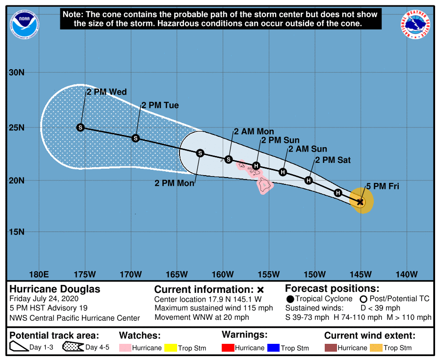
As of the Central Pacific Hurricane Center’s most recent advisory on Douglas at 11:00 AM HST (21:00 UTC), the eye of Hurricane Douglas was located near 17.9°N, 145.1°W, about 665 mi (1070 km) east of Hilo, Hawaii, and about 865 mi (1390 km) east-southeast of Honolulu, Hawaii. Maximum sustained winds are near 115 mph (185 km/h) with gusts to 140 mph (220 km/h), and the minimum central pressure is 967 mb (28.56 inches). Tropical storm-force winds extend outward up to 105 mi (165 km) from the center, and hurricane-force winds extend outward up to 25 mi (40 km) from the center. Douglas is moving toward the west-northwest at around 20 mph (31 km/h), and this general motion is expected to continue through Saturday, followed by a turn to the west and a decrease in forward speed. On the CPHC’s forecast track, the center of Douglas will be near the Hawaiian islands Saturday night through Sunday night. Douglas is forecast to continue to gradually weaken through the weekend, although it is still forecast to be near hurricane strength when it nears the islands. By Saturday night, Douglas is forecast to weaken to a tropical storm, and continue weakening afterward. Although the official CPHC forecast track currently shows Douglas maintaining tropical storm strength through mid-week, it is possible that the cyclone could become post-tropical before then if it quickly loses deep convection.
Forecast Track, Intensity Guidance, and Hazards Affecting Land
Douglas is forecast to maintain a generally west-northwestward to westward motion over the next several days, which will bring it very close to the Hawaiian islands over the weekend. Gradual weakening is expected to continue over that time as Douglas encounters a less favorable environment. The global models and dynamical model guidance are in nearly unanimous agreement on the future track and intensity of Douglas, although there remains some uncertainty in how strong Douglas will be as it approaches the islands. The slower Douglas weakens, the further north it will likely track, and it is possible that Douglas could move further north than currently forecast.
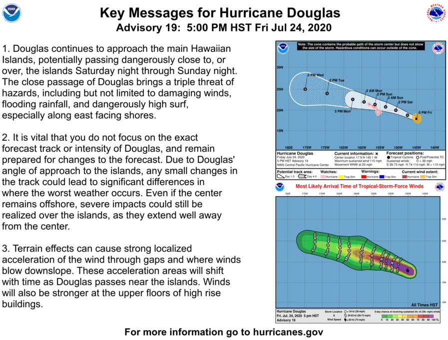
Regardless of Douglas’ intensity when it nears the Hawaiian islands, damaging winds, heavy rainfall, and dangerously high surf conditions are likely across much of the Hawaiian islands over the weekend. Heavy rainfall, in particular, can lead to widespread flash flooding and landslides, especially in mountainous and low-lying terrain. Terrain effects can cause acceleration of storm wind through gaps and downslope, and these shift areas will change as Douglas passes near the islands. It is important that users do not focus explicitly on the exact forecast track and intensity of Douglas, as these are both subject to change, and dangerous conditions can occur well away from the center of the storm. Please refer to the National Hurricane Center and your local National Weather Service for further information regarding Hurricane Douglas.
External Links
Please refer to the National Hurricane Center and National Weather Service websites for further information regarding Hurricane Douglas as well as watches and warnings in effect. Force Thirteen will be providing live coverage on Hurricane Douglas through the weekend in addition to coverage on Atlantic tropical storms Gonzalo and Hanna. More information can be found at Force Thirteen’s official outlets, including its Twitter and Facebook pages.
