East Asia is also facing a strong cold surge, entirety of China is now under freezing cold weather

Apart from the severe weather brought by Nor’easter in US and Storm Bella in northern Europe, at the opposite side of the world, a very high pressure area has formed over Mongolian Plateau on 27/12 and plunged southwards. This is the most intense cold surge since the 2016 January one, and as of midnight 30/12 (UTC+8), the cold front has already passed China, entering the open waters, covering the whole Chinese landmass. Here I’ll break down the impact brought by the cold surge base on different parts of China.
Formation of the cold surge
Due to rapid warm air mass flushing to the Arctic, the Arctic Oscillation Index (AOI) has turned negative, favoured Arctic cold air moving southwards. Latest AOI has reached -3.0 and is expected to drop further next week. That’s why extremely cold weather has come to place in the US and northern Europe as well first. Now, it’s Asia’s turn to meet the freezing weather. As models expected, a high pressure area formed over Siberia on 27/12 and the pressure was incredibly high. Multiple reports from Mongolia has stated that the intensity of the cold surge may have reached 1090hPa. At 7am local time 29/12, the extrapolated mean-sea-level-pressure (MSLP) at Tonsontsengel reached 1091.9hPa. In Khovd, Mongolia (1391m elevation), the highest extrapolated MSLP even reached 1094.3hPa at 1am 29/12, which is a new world record. Currently near the center of the high pressure, the pressure has gone down to around 1070hPa, but still, the temperature was still very low despite of rising pressure, which means a higher temperature. The temperature in Mongolia in general right now is still about -30C.
In China the Orange Cold Surge Warning is still in affect, and the Central Government has called for a grade 3 emergency response.
Situation in North and Northeast China
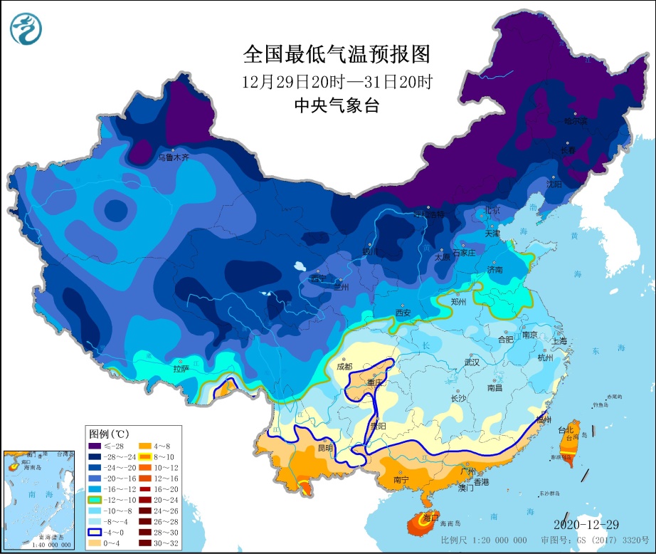
When a cold surge forms, the place where needs to bear the burnt is the northern part of China. Since 28/12, Inner Mongolia and the Northwest Region experienced a 15-19C drop in temperature to generally -20C in average. In Heilongjiang province it’s even colder. Yesterday the lowest temperature in many cities has reached -30C, while in Mohe city, even it dropped to -44.3C, which is similar to the situation in 2018, with lowest temperature of -45C. Besides, western Gansu, northern Ningxia, Shaanxi, Shanxi and central, northwest Hebei has dropped 6-10C in 28-29/12 and the low temperature in North and Northeast China is expected to sustain until this weekend and reaches the lowest point tomorrow. It’s also expected the -20C weather will be north of Kunlun mountain ranges to north of Huanghuai.
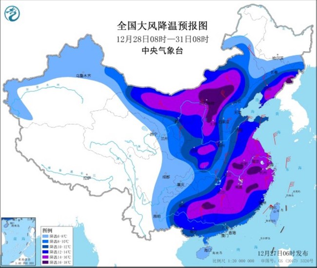
At the eastern part of the Northwest, Inner Mongolia the north and northeastern China, northerly wind with Beaufort force 6-8 wind gust generally, or force 9-10 in some places will remain in effect in the next two days, and the relative humidity will remain very dry with no precipitation.
Situation in Central and East China
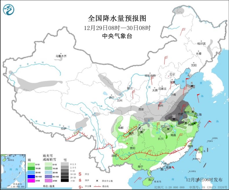
The main body of the cold surge has arrived to Central and East China yesterday daytime, bringing freezing but wet weather. In 29-31/12, it’s expected to, or have dropped 12-16C in Jianghuai, Huanghuai and Jiangnan regions, with some areas may drop more than 16C. The above region is experiencing force 4-6 sustain wind with gale gusts from the north, while highland or coastal areas may even have gale sustain and storm force gusts. When the temperature plummeting has completed, the -10C isotherm is expected to lie at southern Huanghuai region to Qinling mountain ranges. The 0C isotherm is expected to press down to around 25N, excluding Sichuan Basin (concave terrain) due to fohn wind effect. Different from the higher latitude region, East, Central and northern part of South China experienced snow or snow/rain transition, with temperature around -5 to -10C only. On Monday, eastern Henan has recorded snowfall of 2-9mm, and worse for central part, which recorded 10-14mm accumulated snow. Moreover, Shandong has snowfall accumulated snowfall of 30-80mm as of 7am yesterday. Such blizzard weather continued in central eastern part of China like central-southern Anhui, northern Jiangsu, southern Henan and Shandong peninsula, with over a centimeter of snowfall dumped. Since Wednesday, the precipitation in central and eastern part of China will come to an end and become dry, sunny weather, but remain freezing. Frost will still occur in China except Sichuan Basin and southernmost part of China. Drizzles or little sleet may still occur in some places in southwestern China in the next day or two.
Situation in Southern China and Taiwan
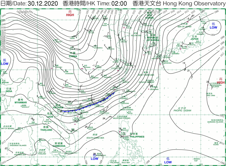
Since yesterday morning the cold front started to sweep south China and still remain intense even the cold surge passed through several mountain ranges like Kunlun-Qinling and Nanling, in which they have a function of blocking cold air to the south. Temperature has dropped rapidly in southern China, from over 20C to below 10C within 6 hours for inland cities, with winds ramped up quickly when the front was passing from 2-3 Beaufort force to gale within a short time as well. After that, on Wednesday, the minimum temperature will probably drop to -5 to 10C, higher when decreasing down the latitude. It’s expected that the relative humidity will also drop to below 50% and clear sky until the second day of 2021, unlike the cold surge in 2016, which brought freezing rain and sleet. While in Taiwan, it’s wetter instead, with rainfall recorded in coastal areas and northern Taiwan, and is expected to last for 2-3 days. before sunshine, the temperature in south China sea coast region like Zhuhai, Hong Kong and Macau, the temperature will drop to ~12C in the morning by a ~2C drop per hour trend before the temperature reaches the minimum as sun rises, and reaching the lowest point on Thursday or Friday, with minimum temperature predicted to be 5-7C, and even several degrees lower for highland and New Territories in Hong Kong due to environmental lapse rate and weaker heat island effect.
Impacts to other places in Asia
Later on, this cold surge may even successfully survive over waters and reach Vietnam, Thailand, bringing the temperature there down by 6-8C to 8-16C on Thursday and Friday.
For waters around China gale to storm force winds is expected to affect like northern South China Sea, Bohai Sea and Yellow Sea for several days. Yellow Strong Wind Warning remains in force, issued by China Meteorological Administration.
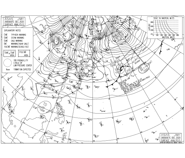
With the cold air blockade by Changbai-Wuyi mountain ranges, the impact east of China is restricted. However, it’s forecasted that a very intense extratropical cyclone is ready to form in the sea of Japan, taking the advantage of the huge baroclinic instability brought by the cold surge. both ECMWF and GFS is predicting this will reach a pressure below 930hPa in Bering Sea, and may get close to the record of ex-typhoon Nuri, with pressure of 924hPa at peak. Hence it can cause blizzard to Japan.
