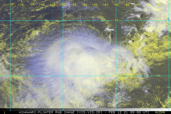
Faraji continues to weaken, but could regenerate in the future

Faraji has a very drastic life, with two rapid intensifications and two peaks. The second peak even reached category 5 status! Now Faraji continues to weaken, now to a tropical storm, and is expected to weaken substantially due to increasing wind shear. In this article, we will review the past of Faraji of two rapid intensification process, weakening, current information, and last but not least, the forecast track.
First rapid intensification right after it formed

A well-defined low-pressure area formed on February 4 and it quickly developed. On the next day, it was named Faraji by Meteo France La Reunion (MFR) and numbered 19S by JTWC. By the time Faraji had formed a decent curved-band pattern, meaning that it evolved significantly. This trend even went more rapid as it used only 2 days to ramp up from tropical storm to category 4 cyclone (SSHS) under very low wind shear, 29C sea surface temperature, and no dry air disruption. From satellite imagery, Faraji had a nearly 20C eye and an around -65C CDO ring surrounding the eye, with Dvorak T value yield of around 6-6.5. However, this peak was short as it has kept a very slow movement in the past 3 days because the steering current near the Equator has offset that from the subtropical high pressure area southwest of Faraji, which means Faraji didn’t have a clear movement motivated by the current. For such, stalling depleted the ocean latent heat energy underneath it, causing an upwelling effect. The sea surface temperature has dropped by 6C when Faraji stalled at that moment. Hence, the convection warmed up and the eye was enlarged and slightly cooled down because of that on earlier February 8th.
Second rapid intensification occurred, leading Faraji to a higher peak

But then, as the steering current from the Equator weakens, Faraji accelerated to the east, leaving the cold pool made by itself. So very warm sea surface temperature supported it once again, and fostering it to rapidly intensify for the second time. A lot of gravity waves blasted at the CDO ring of Faraji, meaning that it was recovering. Then it organized the convection that fired up and the CDO edge became smoother. What’s more, the convection has also deepened, with cloud tops temperature of almost -80C surrounding the eye which had a temperature of around 15C. A SAR pass (a polar satellite), scanned on Faraji successfully at 12:57 p.m. UTC, spotted a gust of 150.9kt at the southwest quadrant, which was translated to 130-135kts (150-155mph) 1-minute sustained winds, by Harper recommended wind conversion and a little overestimation was considered. But at the time, it was still intensifying for several more hours, and at 18:00UTC, both MFR and JTWC analysis stated that Faraji had reached a Dvorak value of 7.0, and upgrade it to very intense tropical cyclone status (10-min sustained: 230km/h; pressure: 927hPa) and category 5 cyclone (1-min sustained: 260km/h; pressure: 920hPa) respectively. Again, this peak was also brief and it started to weaken as northwesterly wind shear increased that blocked the outflow to the Equator. The eye then became cloud-filled, after a day, it fell from 160mph to 105mph.
Fighting against shear while making a drastic turn

Faraji turned from east to southwest from 9th to 11th, while maintaining a movement speed of 5-10km/h. Despite the strike of 20-25kts wind shear, it refused to weaken as it continuously blew convection upshear, and the outflow produced was able to somewhat offset the adverse impact to the storm such that the integrity of the core was maintained. Microwave imagery, showing low to mid-level structure, supported such a claim. That is why it held at category 2 intensity for over a day, temporarily stopped the weakening trend.
However yesterday (11th February), wind shear further intensified and Faraji failed to withstand that. The lower level eye began to collapse and convection has started to further sheared to the south and unable to roll an eye again. Its intensity slipped down more rapidly and lost hurricane-equivalent cyclone status.
Current Storm Information
As of 06:00UTC February 12th, MFR has the storm at 18.3S 82.3E, with maximum 10-minute sustained winds of 120km/h and a minimum central pressure of 977hPa, moving WSW at 20km/h.
While at the same time, according to JTWC’s analysis, it has Faraji at 18.3S 82.1E, with maximum 1-minute sustained winds of 70kts (130km/h) and a minimum central pressure of 984mb, moving 255 degrees true bearing at 11kts (20km/h).
Simultaneously, according to Force Thirteen analysis, we have it at 18.3S 82.4E, with maximum 1-minute sustained winds of 65kts (120km/h) and a pressure of 986mb, moving WSW at 20km/h.
Forecast Track

Strong wind shear is expected to sustain for 2 more days before relieving, so Faraji is also forecasted to continue weakening to a weak tropical storm maintain this intensity for a day. After that, as Faraji is expected to move WNW after 3 days and back to ITCZ, it may re-intensify, and some models even predicted that Faraji will strike La Reunion or Madagascar next week, while some others disagree and predicted that it will just dissipate.
Elsewhere in the tropics, 20P is near dissipation as it turned extratropical yesterday. Also, 93S is swirling inland in Mozambique right now and might have a chance to become a tropical cyclone.
