First April Tropical Depression on Record Forms in the Northeastern Pacific Ocean

The disturbance over the central Northeastern Pacific acquired a well-defined center of circulation today, and has been designated by the National Hurricane Center (NHC) as Tropical Depression One-E. This marks the earliest formation of a tropical cyclone in the Eastern North Pacific since the beginning of the satellite era in 1966, and also the earliest in the official records for the region, which extend back to 1949. As of the National Hurricane Center’s most recent advisory at 8:00 AM PDT (15:00 UTC), the center of Tropical Depression One-E was located near 14.1°N, 116.1°W, about 730 mi (1175 km) southwest of the southern tip of the Baja California Peninsula. Maximum sustained winds are near 35 mph (55 km/h), gusting to 45 mph (75 km/h), and the minimum central pressure was 1006 mb (29.71 inches). The cyclone is moving toward the northwest at near 7 mph (11 km/h), and this general motion is expected to continue through the next 24 hours, followed by a turn toward the west on Sunday. Little change in strength is forecast through Sunday as the depression is expected to be moving over cooler waters by Sunday. However, it is not out of the question that the depression could briefly become a tropical storm later today, in which case it would receive the name Amanda, which is first on the predetermined list of names to be used this year in this basin. No tropical cyclone watches or warnings are currently in effect, and the depression is forecast to remain over the open waters of the Northeastern Pacific Ocean.
Forecast Track and Intensity
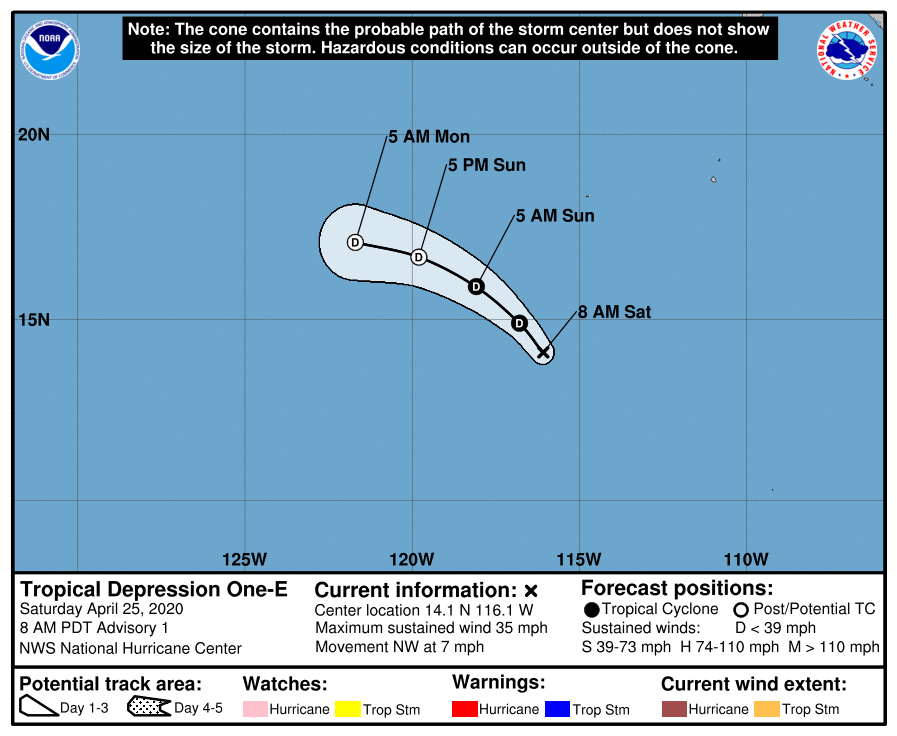
Tropical Depression One-E is likely to be a short-lived tropical cyclone as it moves generally northwestward over the open waters of the Northeastern Pacific. The official NHC forecast shows the depression moving generally northwestward through Sunday morning, followed by a turn to the west Sunday evening, in good agreement with the numerical model guidance. The depression is not forecast to strengthen any further, although some short-term strengthening is possible through Sunday morning, as indicated by a small number of computer models. Cooler waters, strong westerly shear, and a drier air mass are expected to result in a quick demise of the depression by Sunday night, if not sooner. The remnants of the depression may linger for a little while after, but any trace of the system should be gone by Tuesday morning.
Tropical Depression One-E joins only a small number of tropical cyclones which have developed before the start of the Eastern North Pacific hurricane season, which officially begins on May 15. It is also by far the earliest, besting the previous-holder, 2017’s Tropical Storm Adrian, which formed on May 9, by quite a large margin. While the depression’s development is anomalous, it likely isn’t any indication of seasonal activity. The National Oceanic and Atmospheric Administration (NOAA) issues their first forecast of tropical cyclone activity for the Eastern North Pacific, as well as the North Atlantic, in May.
For more information regarding current activity in the tropics, visit Force Thirteen’s official outlets at the official Force Thirteen YouTube channel, Twitter, and Facebook pages.
