Fred and Grace to bring rain and TS winds for Southeast US and Caribbean

Infrared satellite view of Tropical Storm Grace, courtesy of tropicaltidbits.com
[CURRENT STATUS]
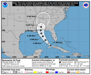
Fred continues to be disorganized as it enters the Straits of Florida. As per 11 AM AST advisory of the National Hurricane Center, Fred was located at 23.3N 83.2W or about 50 miles (80 kilometers) west of Havana, Cuba with sustained winds of 35 mph with gusts up to 45 mph, and a minimum central pressure was at 1013 millibars. The storm is currently moving west-northwest at a speed of 12 mph.
Tropical Storm Grace became slightly stronger as it quickly moves towards the Leeward Islands. As per 11 AM AST advisory of the National Hurricane Center, Grace was located at 16.2N 57.9E or about 265 miles (425 kilometers) east-southeast of the Leeward Islands with sustained winds of 45 mph and gusts up to 60 mph. The minimum central pressure was estimated to be at 1005 millibars. The storm is currently moving west at speed of 23 mph.
[CURRENT WARNINGS]
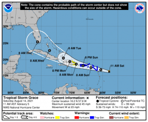
For Tropical Storm Grace:
Tropical Storm Warning (Tropical storm conditions are expected somewhere within the warning area within 36 hours.)
- Antigua and Barbuda, Anguilla, St. Kitts and Nevis, and Montserrat
- Saba and Sint Eustatius
- Sint Maarten
- St. Martin and St. Barthelemy
- British Virgin Islands
- U.S. Virgin Islands
- Puerto Rico, including Vieques and Culebra
Tropical Storm Watch (Tropical storm conditions are expected somewhere within the warning area within 48 hours.)
- South coast of the Dominican Republic from Punta Caucedo to Cabo Engano
- North coast of the Dominican Republic from Cabo Frances Viejo to Cabo Engano
Interests in the Dominican Republic and Haiti should monitor the progress of this system. Additional watches and warnings will likely be required for this area later today.
[FORECAST]
For Remnants of Fred:
A turn to the northwest is expected by tonight, followed by a northward motion by Sunday night. On the forecast track, Fred is expected to pass west of the lower Florida Keys this afternoon, move across the eastern Gulf of Mexico tonight through Monday, and move inland over the northern Gulf coast Monday night. Regeneration as a tropical system and some strengthening is forecast, and Fred could become a tropical storm again tonight or on Sunday.
RAINFALL: Remnants of Fred is expected to produce the following rainfall amounts:
- Portions of Cuba: 2 to 5 inches with isolated maximum totals of 8 inches.
- Across the Bahamas: 1 to 3 inches, with isolated maximum totals of 5 inches.
- Across the Keys and Southern Florida:3 to 5 inches are anticipated
- Across the Florida Big Bend and Panhandle: Through Monday, 3 to 7 inches with isolated maximum totals of 10 inches are expected.
This rainfall may lead to scattered flash flooding. Rainfall due to Fred is expected as far inland as Southern Appalachian starting Monday.
WIND: Wind gusts to tropical-storm force are possible in squalls today across the Florida keys and the southern portion of the Florida Peninsula.
SURF: Swells generated by Fred are expected to spread across the Florida Keys later this morning and reach the coast of Alabama and the Florida Panhandle on Monday. Please consult products from your local weather office for more details.
TORNADOES: A tornado or two may be possible starting this afternoon across portions of central and southern Florida.
For Tropical Storm Grace:
A motion toward the west with a gradual decrease in forward speed is expected during the next few days. On the forecast track, the center of the storm is forecast to move over the Leeward Islands tonight, over the Virgin Islands and Puerto Rico on Sunday, and then over the Dominican Republic on Monday. Some strengthening is forecast during the next couple of days. Weakening is expected early next week as the system interacts with the Greater Antilles.
RAINFALL: The system is expected to produce the following rainfall amounts later today into Monday:
- Over the northern Leeward Islands and Virgin Islands: 3 to 6 inches.
- Over Puerto Rico: 3 to 6 inches.
This rainfall may lead to scattered flash flooding. Heavy rainfall from this system could impact Florida late next week.
WIND: Tropical Storm conditions are expected within the warning area over the Leeward Islands by tonight or early Sunday, and the Virgin Islands and Puerto Rico beginning on Sunday.
