Future of Newly Designated Potential Tropical Cyclone 02L still Uncertain, but Heavy Rains are Coming to the Gulf Coast

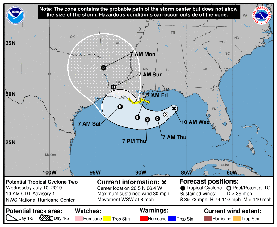
Yesterday, Invest 92L emerged over the Gulf of Mexico as a broad area of low pressure. It has consolidated more today, and the National Hurricane Center is giving it a near 100% chance of becoming a tropical cyclone. In addition, due to its proximity to land, they have also initiated Tropical Storm and Storm Surge Watches for portions of eastern Louisiana, therefore deeming 92L as Potential Tropical Cyclone 02L. The system currently has winds of 30mph, has a pressure of 1011mb, and is located about 170mi east-southeast of the Mississippi River Delta.

As of now, the system is still rather disorganized and not yet classifiable as a tropical cyclone despite the warnings and near guaranteed chance of it becoming one. PTC 02L is rather broad and remains decoupled, as the northerly shear from a ridge centered over northern Mississippi. In fact, the most intense thunderstorm activity is currently over southeastern Louisiana. The mid-level vortex is displaced to the south of the low-level center as a result, not allowing for rapid organization at this stage, as was expected. The low-level center is also quite difficult to discern, as multiple vorticity maximums continuously form and dissipate about a center of rotation, the location of which is unclear. However, as the diurnal maximum approaches, more convection is expected to fire in the vicinity of the surface vortex. This will more than likely allow for further strengthening into a tropical cyclone by tonight or tomorrow.
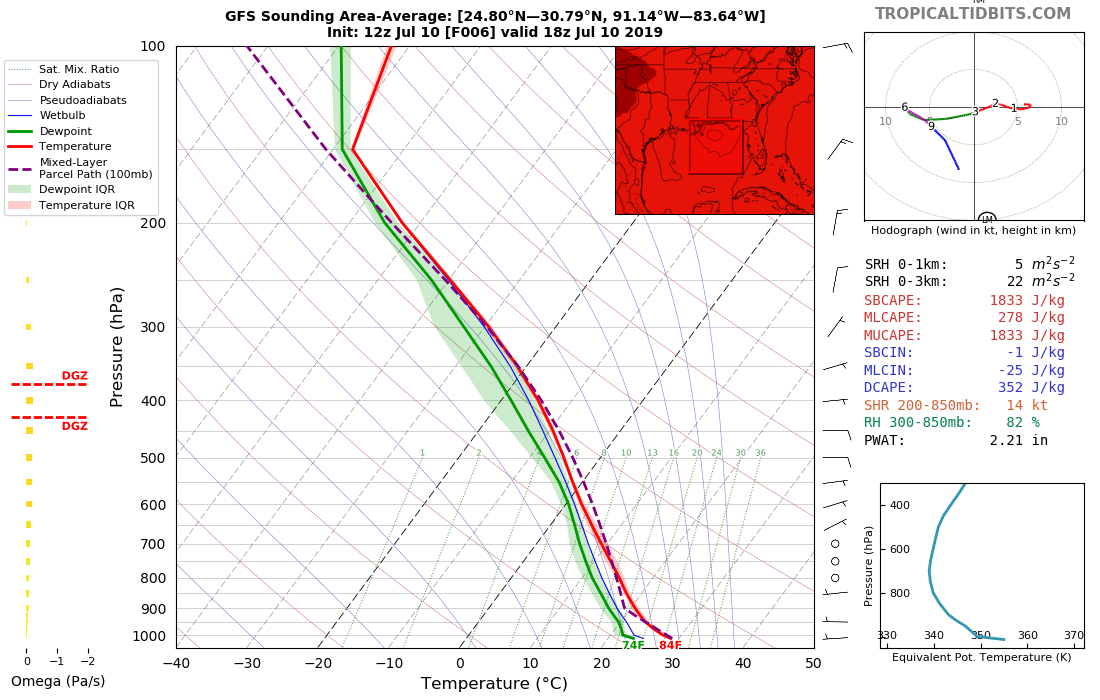
The forecast for PTC 02L remains rather murky at this point given uncertainties between the models in regards to both track and intensity. Steering currents over the system are weak for now, but a ridge building over the Four Corners region will cause the system to move slowly westward with time. Meanwhile, as a trough dips through the Great Lakes region, it will drag a cold front through the eastern U.S. It in tandem with a ridge near the Bahamas will act to tug the storm northwards this weekend, likely somewhere along the Louisiana Gulf Coast.

A big question mark going into this system is how strong it will become. The majority of the guidance suggests that will peak as a strong tropical storm, but there are also plenty of models that suggest that PTC 02L could become a hurricane and a select few saying a pretty powerful one at that, namely the UKMET and previously the HWRF. If the storm remains weaker, as in a tropical storm, it will curve north earlier into southeastern Louisiana. This is because the SWerly flow initiated by the frontal boundary is based towards the surface, and a weaker storm would not extend as high up into the troposphere as a more intense storm would. If the storm is a stronger hurricane, then it may slip farther west before turning north along the Upper Texas Coast or far western Louisiana as the Bahamas ridge will shift closer to Florida and would ultimately cause the storm to turn north. Either of these solutions remain on the table, but it is uncertain which solution will prevail.
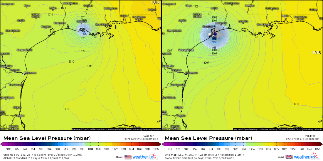
At this point, the National Hurricane Center is splitting between the two extremes and is forecasting a landfall in western Louisiana as a category 1 hurricane with winds of 85mph on Saturday evening. It should be noted, however, that the cone extends as far west as Houston and as far east as New Orleans, so anywhere between those two points is likely to receive the eventual landfall of this storm.
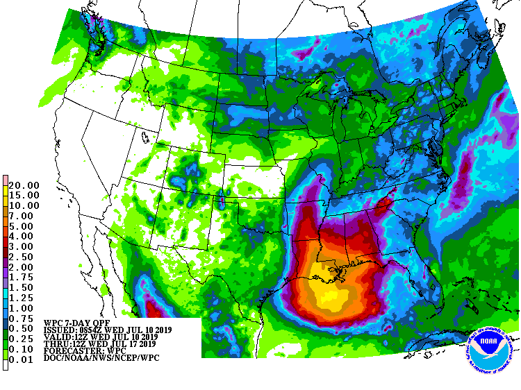
Regardless of where the system makes landfall and how strong it is, very heavy rains are certain to fall. New Orleans has already suffered from flash flooding this morning, and the system is not even a tropical cyclone yet. Areas near and east of the landfall point should expect anywhere from 8-12 inches of rain with isolated totals potentially as high as 20 inches east of the landfall point, which is still not yet known. Given that the Mississippi River is already much higher than normal due to heavy rains all throughout the river basin, heavy rains from this system will only exacerbate issues. Rainfall is by far the biggest threat from this system, much more so than wind and even storm surge, but those threats will become clearer as the forecast track and intensity becomes more certain. Even areas inland into Mississippi, Alabama, northern Louisiana, Arkansas, and Missouri can also expect heavy rains and potential flash flooding from this system as well. The rainfall threat for Texas is lower given that the landfall is expected to be east of the state and the western side will be drier, but a further west landfall would shift the heavy rains towards them.
In the meantime, an aircraft reconnaissance mission is scheduled to investigate the system this afternoon, which will give us a better idea of the internal structure of the storm. If this storm does gain a name, which is almost a certainty at this stage, it will be named “Barry”. Please make sure you have your hurricane and flooding preparations ready if you are in the path of this storm, and always listen to the information given to you by your local NWS office or outlets for the latest information regarding this potentially damaging system. Stay tuned here to Force Thirteen for more up-to-date information regarding this system.
