Gamma Moving over the Yucatan Peninsula; Watching the Caribbean and Central Atlantic

Tropical Storm Gamma made landfall on Mexico’s Yucatan Peninsula earlier today, and was very close to hurricane strength as it made its way onshore. Maximum winds at landfall were 70 mph (110 km/h), and the minimum central pressure was 980 mb. Gamma is the twenty-fourth named storm of the record-breaking 2020 Atlantic hurricane season, and is the earliest such storm on record; Hurricane Beta of 2005 was the previous record holder when it developed on October 26. Gamma is expected to weaken slightly as it moves over the Yucatan Peninsula, and is expected to move into the Gulf of Mexico on Sunday. Elsewhere in the North Atlantic, there are three other systems worth mentioning, with a tropical wave in the central Caribbean Sea warranting a close eye.
Tropical Storm Gamma: Current Storm Information
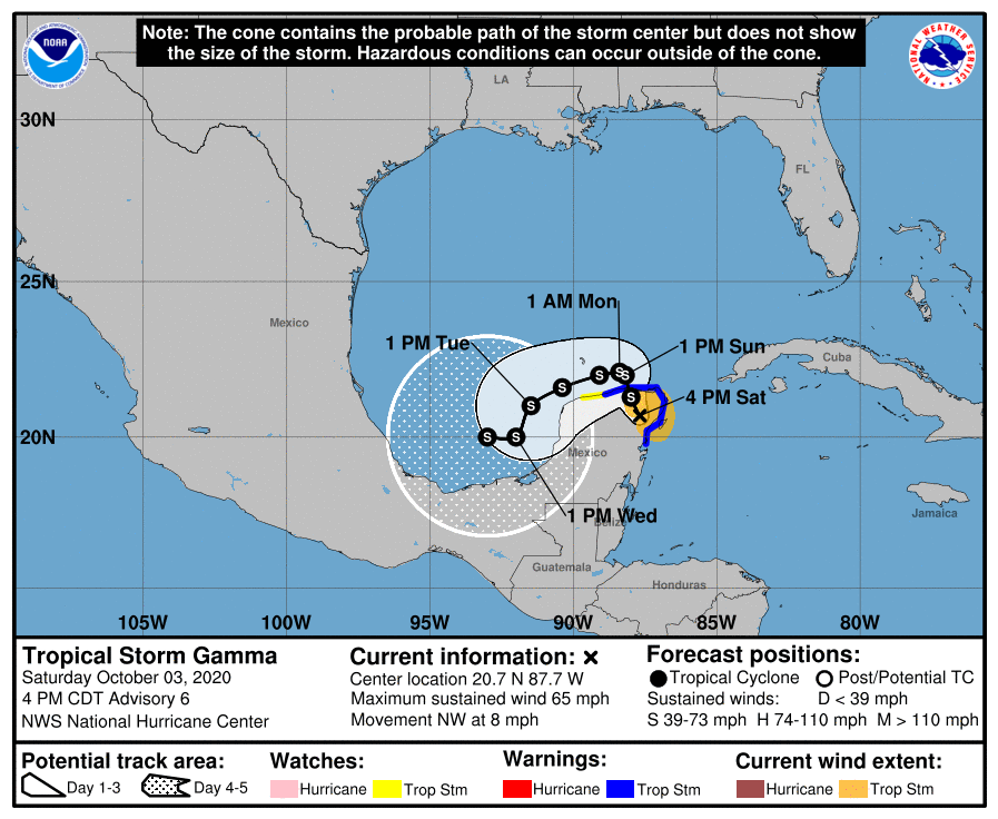
As of the National Hurricane Center’s most recent advisory on Gamma at 5:00 PM EDT (21:00 UTC), the center of Tropical Storm Gamma was located near 20.7°N, 87.7°W, about 35 mi (60 km) north-northwest of Tulum, Mexico. Maximum sustained winds are near 65 mph (100 km/h) with gusts to 75 mph (120 km/h), the minimum central pressure is 985 mb (29.09 inches), and tropical storm-force winds extend outward up to 80 miles (130 km) from the center. Gamma is moving toward the northwest at around 8 mph (13 km/h), and this general motion is expected to continue through tonight and Sunday with a decrease in forward speed. A turn to the west or west-northwest is expected to begin Sunday night or Monday. On the NHC forecast track, the center of Gamma will continue to move over the Yucatan Peninsula today and move into the southern Gulf of Mexico on Sunday. Gamma is expected to continue weakening today while it is over the Yucatan Peninsula, but some restrengthening will be possible when the center moves back over water by Sunday afternoon. Afterward, little change in strength is expected as Gamma meanders over the southwestern Gulf of Mexico.
Forecast Track, Intensity Guidance, and Hazards Affecting Land
Gamma’s future is rather uncertain at this time, and current official forecasts are of rather low confidence. Steering currents are expected to be rather weak over the Gulf of Mexico as a weak ridge builds over the area. The global models suggest that Gamma will be moving slowly westward over the Gulf of Mexico next week, perhaps losing some latitude as the ridge builds. By midweek, the cyclone will likely be over the Bay of Campeche, although details of the track forecast beyond that time are rather uncertain. Although some restrengthening may occur after the center of Gamma moves over the Gulf of Mexico, the dynamical model guidance is not very supportive of any significant intensification. The track and intensity guidance could be further complicated by another system (Invest 92L) currently located over the central Caribbean Sea, which could develop into a tropical cyclone next week.
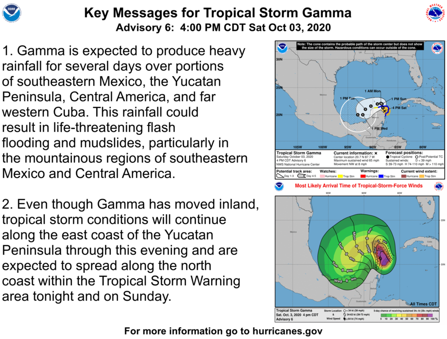
Gamma is expected to continue to produce heavy rainfall for the next several days over portions of the Yucatan Peninsula, southeastern Mexico, Central America, and western Cuba. The storm is expected to produce total rainfall accumulations of 4 to 8 inches across portions of the Yucatan Peninsula, with isolated amounts of up to 12 inches. Total rainfall accumulations of 4 to 6 inches and isolated totals of 8 inches are expected over eastern El Salvador, southern Honduras, and northwestern Nicaragua. In western Cuba and the Cayman Islands, rainfall amounts of 1 to 3 inches with isolated totals of 5 inches can be expected. A Tropical Storm Warning is currently in effect from Punta Allen to Dzilam, Mexico, including the city of Cozumel, and a Tropical Storm Watch is currently in effect from Dzilam to Progreso, Mexico. Tropical Storm conditions are expected to continue within the warning area on the eastern Yucatan Peninsula through the next several hours, and should spread across the remainder of the warning area on Sunday. Tropical Storm conditions will be possible in the watch area beginning on Monday.
Watching the Caribbean Sea, Central Atlantic
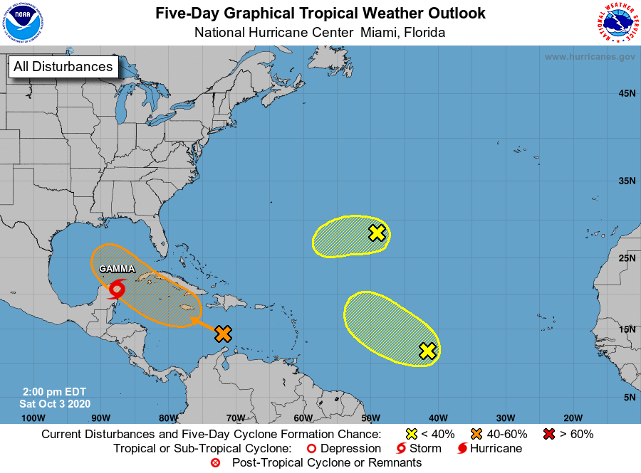
In addition to Gamma, the National Hurricane Center is monitoring three other disturbances for tropical cyclone development. The first and most important of which is Invest 92L, a tropical wave which is located over the Central Caribbean Sea. This system has been given a medium (60 percent) chance of developing into a tropical cyclone during the next five days as it moves westward to west-northwestward over the Caribbean Sea, where environmental conditions are expected to support further development of this system. Locally heavy rainfall and gusty winds will be possible with this system across Hispaniola, Jamaica, Cuba, and the Cayman Islands, and interests in those areas should monitor the progress of this system. In the central Atlantic Ocean, two more systems are being monitored for tropical cyclone development. The first is a tropical wave located over the central tropical Atlantic; some slight development of this system is possible as it moves generally northwestward during the next few days. The second is a surface trough that constitutes the remnants of former Hurricane Paulette, which is located over the central Atlantic to the northeast of the Lesser Antilles. Some slow development of this system will be possible during the next few days before it encounters an unfavorable atmospheric environment by midweek.
External Links
Please refer to the National Hurricane Center and National Weather Service websites for further information regarding Tropical Storm Marco as well as watches and warnings in effect. Force Thirteen will be live with tonight’s Tropical Weather Bulletin, covering Tropical Storm Gamma, Hurricane Marie, and the rest of the tropics on the Force Thirteen YouTube channel at 8:00 PM EDT (00:00 UTC). More information can be found at Force Thirteen’s official outlets, including its Twitter and Facebook pages.

Gamma and Delta are going to probaly make the fujiwhara effect