Goni explodes to a category 5 typhoon, extreme threat to the Philippines

Goni (PH name Rolly) has turned on its full booster, exploding to a category 5 super typhoon. Back in the morning JTWC has put its intensity at 150mph, 934mb as of 08:00, and it jumped for 25mph more with only 6 hours in such strong status already. Currently (20:00) Force Thirteen is going with maximum 1-minute sustain winds of 190mph with a pressure of 894mb at 16.1N 130.8E. It’s expected to move west to west-southwest and strike the Philippines hard as a super typhoon still. Everyone in there should take this very seriously. This storm is not joking.
Current Storm Information

As of 14:00 (0600Z) October 30th, super typhoon Goni is located at 16.3N 131.6E, with maximum 1-minute sustain wind of 150kt (175mph, 280km/h) with a minimum central pressure of 911mb. As of 18Z JTWC analysis on 28/10 (02:00 29/10 UTC+8), it was only a 40mph tropical storm, but soon after, with extremely favourable conditions because of nearly no tropical activities in the past several months it started to explosively intensified, firstly to a 80mph category 1 typhoon just half day after that, than to 175mph super typhoon and a pressure of 911mb as of 14:00 JTWC analysis. It’s expected to continue to move west or west-southwest with 8knots (15km/h) and maintain its intensity for 12 hours, then weaken a bit before smashing the Philippines. Currently (20:00) Force Thirteen is going with maximum 1-minute sustain winds of 190mph with a pressure of 894mb at 16.1N 130.8E. A polar satellite, AQUA measured an infrared eye temperature of +26.7C at 04:40UTC, with a nearly complete cold dark gray ring (cloud tops colder than -80C). Also Goni’s eye is still getting drier and drier and shrinking a bit as well, signaling a very high intensity. Even microwave imagery are not able to catch the eye as it is too small, showing a small eye feature which means higher angular velocity. The evil tiny eyewall is still persisting
Yet many local agencies are severely lagging behind it due to the extremely rapid intensification phase since yesterday, except for Hong Kong Observatory which catches up better. At 14:00 today HKO put Goni at maximum 10-minute sustain winds of 240km/h, and even forecasting a 260km/h peak after 24 hours!
Forecast Track, Threat to Land.
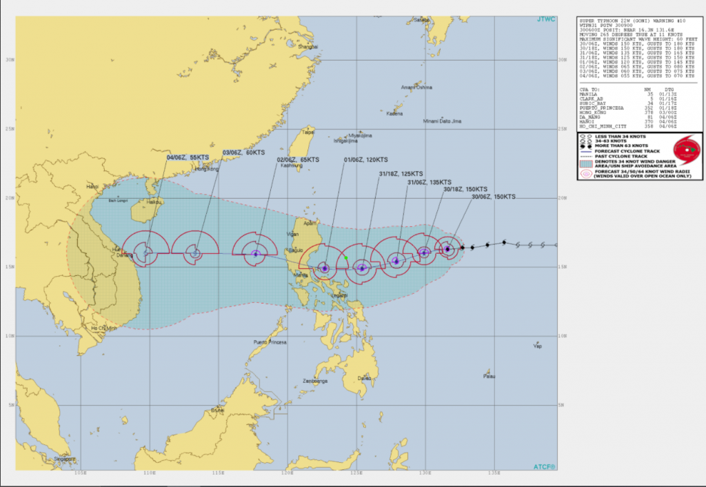
It’s expected to move west or west-southwest and maintain its intensity, then weakens slightly since tomorrow as it approaches Luzon, but its intensity will be strong still as a category 4, or even category 5 typhoon in forecast when it make landfall on central Luzon in the next 2 days. Force Thirteen is forecasting a 155mph landfall. Eyewall replacement cycle is likely to occur tomorrow which means an expansion in Goni’s size and affect more areas. After brushing the Philippines, it will weaken substantially because of upwelling due to previous systems Saudel and Molave, causing a drop in sea surface temperature, and possibly northeast monsoon influence that cause shear and dry air intrusion, then yet again, will probably strike central Vietnam next peak, which is still under the flooding hazard since early in this month.
Currently signal 1 warning is in effect for Catanduanes, Luzon and warnings will extend soon. In addition, PAGASA currently is underestimating Goni now. People in the Philippines, especially in Luzon and Visayas region, must take this seriously and start the preparation procedures such as food reserves and evacuation so as to stay safe. The catastrophic winds, rain and surges are coming in the next day or two.
