Goni (PH: Rolly) Expands and Intensifies- Biggest Threat to the Philippines Since Haiyan
 Expands and Intensifies- Biggest Threat to the Philippines Since HaiyanOctober 31st, 2020 at 19:23 PM • 5 years ago| 0")
While it’s expected that Goni will weaken due to increasing shear and eyewall replacement cycle (EWRC), but another surprise that is a merger eyewall replacement cycle so the intensity didn’t go down too much. Also after EWRC its size doubled, and cloud tops are continuously cooling down. It is expected to maintain its intensity to a large extent when it make landfall in southern Luzon, Philippines as a powerful category 5 super typhoon, with a similar intensity as Mangkhut. Please take this seriously and all in the Philippines get the preparation procedures done now, the landfall is coming within this hour or two. Please listen to the officials for what to do so as to stay safe. It is extremely dangerous!
Current Storm Information

As of 18:00UTC 31/10 (1/11 02:00PHT) Goni was located at 13.7N 125.1E, with maximum 1-minute sustained winds of 175knots (315km/h), with a minimum central pressure of 884mb, which means by JTWC record, it is more intense than Haiyan, and the deepest storm since Forrest 1983! It is moving west-southwest, with an accelerating trend in the last few hours, then will smack Southern Luzon hard within half day. Force Thirteen’s latest 19Z estimates even puts Goni with 1-minute sustained winds of 195mph with a pressure of 876mb, which completely reflects its power.
From satellite, a thick -80C ring has fully embedded the eye, with average ring temperature around -83C! Yesterday a concentric eyewall has formed and it’s expected to weaken more as the eye would collapse and requires time to reorganize. However, convection fired up before the eyewall replacement cycle began as visible in infrared imagery yesterday morning. Goni, ended up finishing a merger eyewall replacement cycle, in which it’s intensity only weakened slightly but also nearly doubled its size. Right now it has finished its EWRC and eye is clearing up for probably the final time and signaling it is still intensifying. Some satellite estimates are going even higher, with SATCON going to 174kts 1-min sustain, AMSU even heading to 181kts. Dvorak estimates are hitting T8.0, which equals to 170kts 1-min sustain.
Ground observations, Cataduanes has reported gale force winds and pressure recorded from Virac at 02:00 has dropped to 993.8hPa. Meanwhile, the Hong Kong Observatory has been holding a 260km/h estimate for Goni for 30 hours now.
Current Warnings in Effect
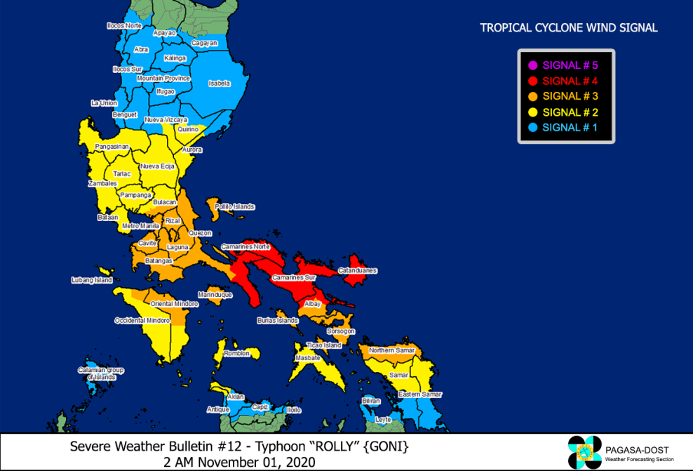
Moreover, in the latest update, PAGASA has upgraded Goni to a super typhoon and signal 5 warning is in effect over Catanduanes, Eastern Camarines Sur, and Albay.
Forecast Track, Threats to Land

Goni (PH: Rolly) is expected to move west-southwest with 15mph, bearing down on the southern Luzon, and putting the whole Philippines under threat. Signs showing that it is still intensifying, and it’s possible to make landfall with a stronger intensity as expected. After brushing the Philippines, due to land interaction and upwelling, Goni will weaken significantly, as well as northeast monsoon influence that bring shear and dry air to Goni which can cause it struggle from restrengthening, In fact the northeast monsoon has being more dominant and push more southward, causing a more southwestward track of Goni yesterday. Due to Goni’s extremely powerful intensity, its intense outflow is still shearing off Atsani which follows behind and remain as a weak tropical depression, but is expected to become a major typhoon as well and imposes another threat to the Philippines next week.
It is a worst case scenario with Molave last week, Goni today and possibly Atsani next week to strike the Philippines one after another, with this one being the strongest landfall, with intensity similar to Haiyan. Filipinos, please prepare well for the storm and finish all preparation procedures by now as it is coming in . Please stay safe and keep strong and cohesive, the extreme, over 300km/h winds are coming!
