Habana Explodes to Category 4, Remains an Intense Cyclone

While Niran is dying off after passing through New Caledonia because of strong wind shear and jet streak interaction, Habana, on the other hand, is holding its category 4 status after unexpectedly exploding from tropical storm to category 4 cyclone in SSHWS in just one day. Currently, it has weakened a bit but it is still a category 4 cyclone by our latest estimates. This article will discuss its explosive intensification process, current storm information, as well as the track of forecast.
Current Storm Information
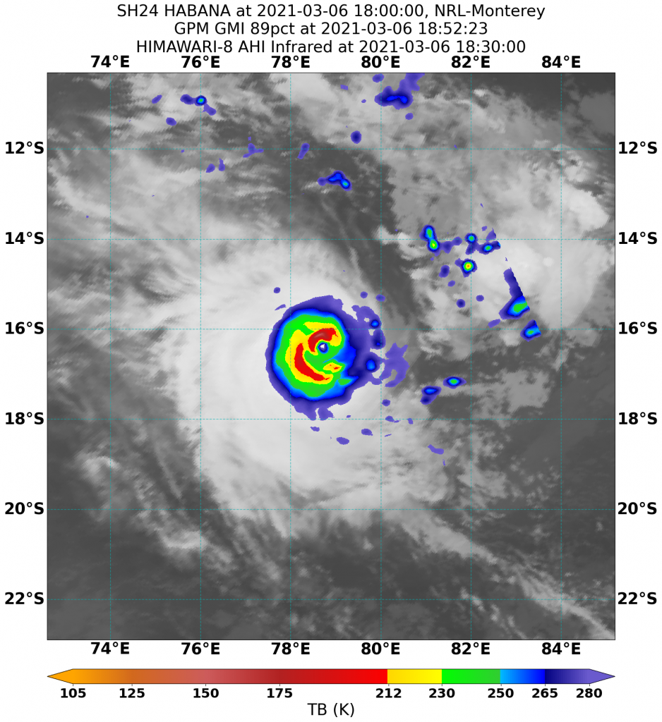
As of the latest Force Thirteen analysis at 18:00UTC March 7th (22:00MUT), Habana is located at 16.6S 78.7E, with maximum 1-minute sustained winds of 130mph (210km/h) and a minimum central pressure of 947mb (27.965inHg), moving ESE at 6mph (10km/h)
At the same time by the latest JTWC estimates Habana is located at 16.2S 78.0E, with maximum 1-minute sustained winds of 140mph (220km/h) and a minimum central pressure of 945mb (27.906inHg), moving 105 degrees (true bearing) (ESE) at 4kts (7km/h)
Simultaneously by the latest MFR analysis, Habana is located at 16.5S 78.8E, with maximum 10-minute sustained winds of 205km/h and gusts of around 285km/h and a minimum central pressure of 940hPa (27.758inHg), yielding it at Intense Tropical Cyclone status in their scale. It is moving SE at 7km/h by their estimate.
Habana is weakening currently due to some poorer upper environment and by microwave imagery, it showed signs of Habana rolling some dry air into its core. Its eye temperature has cooled down to around -20 to -50C fluctuating rapidly throughout the day. Though the convection did become a bit colder as well with -75C cloud tops wrapping around it, yielding a Dvorak Data T Number of T6-6.5 (white ring with off-white to medium grey eye), which supports all the above estimates.
Developmental Process
A few days ago, when the previous form of Habana, invest 90S formed, it was a very disorganized low-pressure area with more than one circulation center fighting against each other. On March 4th, the center at around 16S 72S became dominated, as well as producing 40kts winds, as reflected in ASCAT passes at around 3-5 am UTC, and soon after, microwave imagery even revealed a lower-level eye, which marked its start of very rapid intensification in the next 24 hours.
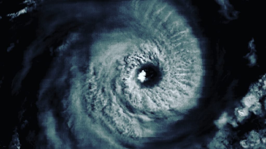
At first, it’s only expected that Habana will only become a high-end tropical storm to category 1 cyclone. However, under nearly perfect dual outflow and low wind shear, as well as 28-29C sea surface temperature, small-sized Habana made optimum use of it and unexpectedly exploded. The eye popped out in infrared imagery before sunrise at its location, and it rapidly clears up during the daytime. A polar satellite pass made by MODIS TERRA at 05:15UTC March 5th, revealed an eye temperature of +18C already by its way better resolution than METEOSAT-8, which only detected a -10C eye. For such, both JTWC and F13, to catch up with its explosive intensification trend, upgraded Habana to category 4 status in the SSHWS at 12nn UTC. During the peak, the microwave imagery showed a very robust core with a complete 200K ring at mid-level. The Dvorak T number even reached 7.0 for several hours, but convection wrapping reflected that the W ring was not solid enough to call a category 5. By JTWC estimates, it peaked with winds of 145kts (230km/h). While by the preliminary analysis from Force Thirteen concludes that Habana did reach a higher intensity with winds of 150mph (240km/h) and a pressure of 935mb. It was indeed very impressive that Habana intensified by 80kts in a 24 hour period. However, its peak was very short-lived. Due to its small-sized structure, Habana is vulnerable to slight environmental changes. With increasing dry air and weaker divergence, its eye became less clear, as well as serious convection wobbling, which indicated that Habana weakened slightly. However, right now it is still very intense and has lasted as a category 4 for around 30 hours.
Forecast Track
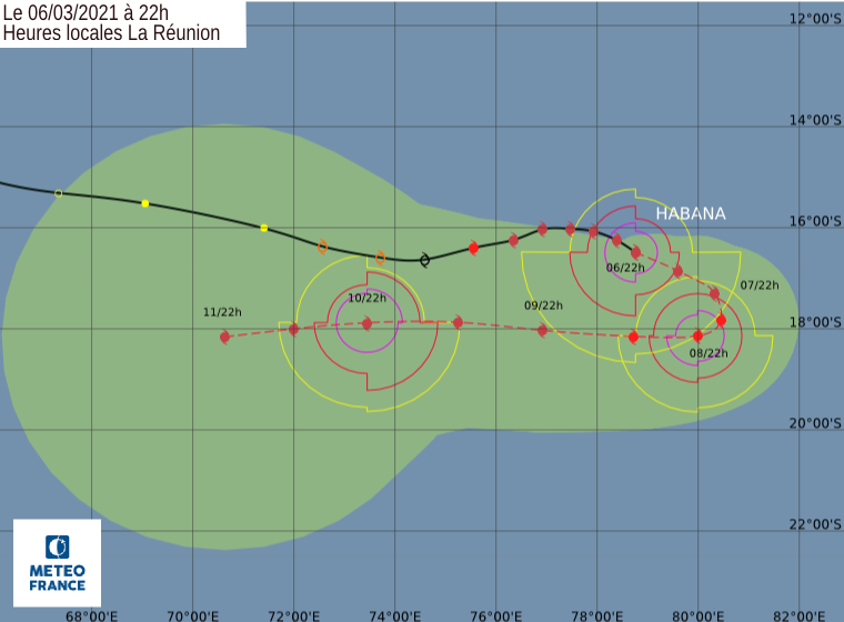
With more and more dry air surrounding Habana, it will wrap in such stable air and weakens in the next 2 days in the latest forecast. Major models do have a consensus that it will continue moving east-southeastward slowly, then make a U-turn towards the west gradually in the next day and two. Then, models started to diverse in terms of Habana’s intensity after the turn, but currently, a re-intensification is still expected by official agencies. Force Thirteen agrees with that. In long run, according to GFS models, it is expected to move westward still, then gradually turn towards the southwest, then to the southeast, before turning post-tropical. However, what will happen afterward is still very uncertain, and the chance of Habana will strike Mauritius and La Reunion next week cannot be ruled out.
Elsewhere in the tropics, Niran has brushed New Caledonia from the south yesterday afternoon local time while rapidly weakening as expected. Currently, it has nearly completed its extratropical transition. 91S has re-entered the Indian Ocean after passing through Madagascar from west to east. It is currently regenerating and will bring some impact to La Reunion.
Stay tuned for the latest storm updates from Force Thirteen by following our Facebook and Twitter page, as well as subscribing to our YouTube Channel.
