Habana Explodes Yet Again with a Higher Intensity, Expected to Remain Intense.

Habana is a fighter that refuses to give up. After substantial weakening to category 1, Habana explodes by at least three categories one more time yesterday. By the latest Force Thirteen estimates Habana is a category 5 cyclone in the SSHWS. Although there is a slight weakening right now due to an ongoing eyewall replacement cycle, it will re-intensify after finishing it, and possibly reaching an even higher intensity.
Current Storm Information
As of 12:00UTC (16:00 MUT) March 10th, according to the estimates by Meteo France La Reunion (MFR), Habana locates at 17.4S 76.2E, with maximum 10-minute sustain winds of 205 km/h and gusts up to 285 km/h, as well as a minimum central pressure of 940mb, moving west at 11 km/h.
In unison, the latest Joint Typhoon Warning Center analysis has put Habana to a category 4 status, with 1-minute sustained winds of 155 mph (250 km/h) and a pressure of 928mb. Habana locates at 17.5S 76.1E, moving west at 7mph (11kph).
At 15:00UTC (19:00 MUT) Force Thirteen analysis thinks it is a high-end category 4 with a 1-minute sustain of 155 mph (250 km/h) and a pressure of 926mb. Habana locates at 17.4S 75.8E and currently moving west at 7mph (11 km/h). Analysis fixes 3 hours before made by Force Thirteen thinks Habana peaked as a category 5 cyclone with winds of 160mph (255 km/h) and a pressure of 924mb.
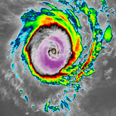
When Habana was making a U-turn from east to west in the last 1-3 days, Habana struggled with dry air intrusion such that it gradually weakened from category 4 to a category 1 cyclone in 2 days, then bottomed at 75mph. Yesterday, with mid-level relative humidity increased to more than 50% again, Habana bottomed out and rapidly intensified for the second time from a minimal category 1 cyclone to a 155-160mph borderline category 5 storm in a day. At peak intensity, it showed a near-perfect central dense overcast (CDO) that is axisymmetric and smooth, with -75 to -80C cloud tops surrounded the eye that has near +20C, completely, which showed its impressiveness of the structure. Despite a marvellous appearance in the infrared imagery, microwave imagery data from polar satellites reflected that something is hindering Habana to go further. A pass from AMSR2 at 08:19UTC (March 10th) indicated signs of an eyewall replacement cycle, as at the low-level, concentric eyewalls are observed. Another scan from SSMIS F-16 at 11:38UTC also suggested it. Soon after the peak, its CDO started to wobble, showing some fractures in it, indicating an eyewall replacement cycle has begun and intensity starts to go downward. What’s more, in the process, it’s likely that Habana is developing annular characteristics based on current satellite appearance.
Forecast Track
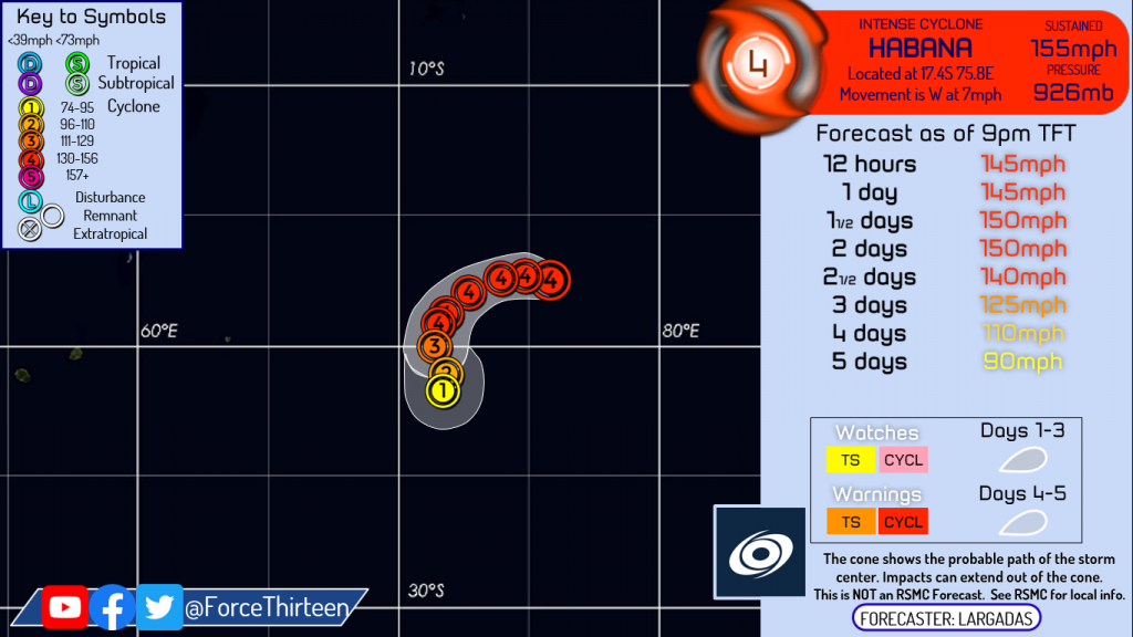
It is expected to weaken a bit as the eyewall replacement cycle is currently in progress. After that, its intensity will climb up again, and make another peak for its intensity curve, with a recovered core. Note that in an eyewall replacement cycle, the uncertainty of where Habana will bottom is high. In general, storms undergoing an eyewall replacement cycle weaken by at least 1 category. While it is making a gradual southward turn in the next few days as remnants of Iman created a fracture between two subtropical high ridges southeast of the southern part of Africa and northwest of Australia, Habana is prognosticated to weaken after peaking in the next 2 days due to increasing wind shear and decreasing ocean heat content. Later on, as the fracture closed, models forecast that Habana will move west again, before another extratropical cyclone creating another fracture to the subtropical high ridge, bringing Habana to the mid-latitudes and ending its journey.
Elsewhere in the tropics, invest 92W is at the south of the Philippines with a low chance of formation. An area of interest northeast of Madagascar might develop in the future.
Please stay tuned for the latest Force Thirteen updates on Facebook, Twitter, and our YouTube channels as well.
