Hurricane Douglas Continues its Approach to the Hawaiian Islands; Conditions Expected to Deteriorate Tomorrow

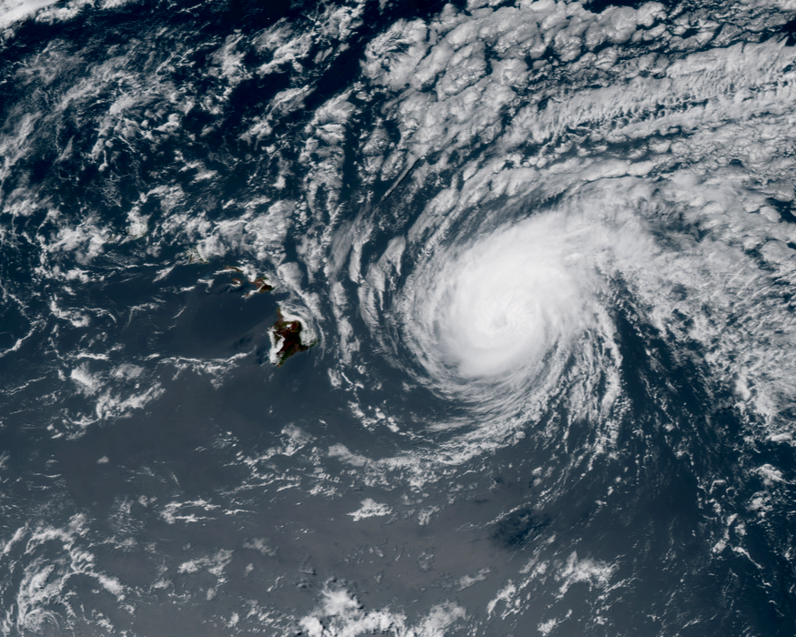
Although it is moving over cooler waters and experiencing the negative effects of moderate vertical wind shear, Douglas remains a hurricane this evening as it continues to gradually weaken. Douglas peaked as a Category 4 hurricane on the Saffir-Simpson scale on Thursday with maximum sustained winds estimated at 130 mph (215 km/h). Douglas is currently a Category 1 hurricane and continues to weaken as it moves generally westward, but is still expected to be near hurricane strength as it passes very near the Hawaiian islands on Sunday. Conditions are expected to begin to deteriorate on Sunday as Douglas approaches, and the hurricane is expected to bring damaging winds, heavy rainfall, and dangerous surf conditions to much of the Hawaiian islands.
Hurricane Douglas: Latest Storm Information

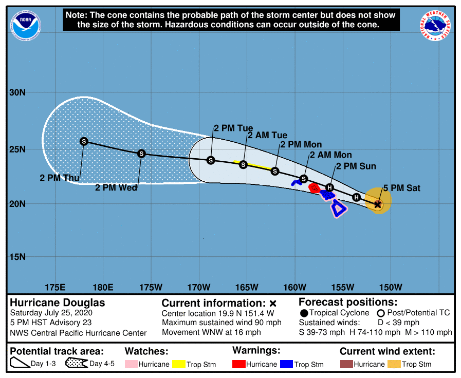
As of the Central Pacific Hurricane Center’s most recent advisory on Douglas at 2:00 AM HST (00:00 UTC), the center of Hurricane Douglas was located near 19.9°N, 151.4°W, about 240 mi (385 km) east of Hilo, Hawaii, and about 430 mi (695 km) east-southeast of Honolulu, Hawaii. Maximum sustained winds are near 90 mph (150 km/h) with gusts to 115 mph (185 km/h), and the minimum central pressure is 982 mb (29.00 inches). Tropical storm-force winds extend outward up to 115 mi (185 km) from the center, and hurricane-force winds extend outward up to 35 mi (55 km) from the center. Douglas is moving toward the west-northwest at around 16 mph (26 km/h), and this general motion is expected to continue through the next few days. On the CPHC’s forecast track, the center of Douglas will be moving near, or over, the Hawaiian islands Sunday and Sunday night. Douglas is expected to continue weakening as it continues westward, although it is forecast to still be near hurricane strength when it passes near the islands. Douglas is forecast to weaken to a tropical storm Monday morning, and continue to steadily weaken thereafter. On the CPHC’s forecast track, the center of Douglas will cross the International Date Line on Thursday. If Douglas is still a tropical cyclone by that time, the Joint Typhoon Warning Center (JTWC) will assume the responsibility of issuing bulletins on the cyclone.
Hazards Affecting Land

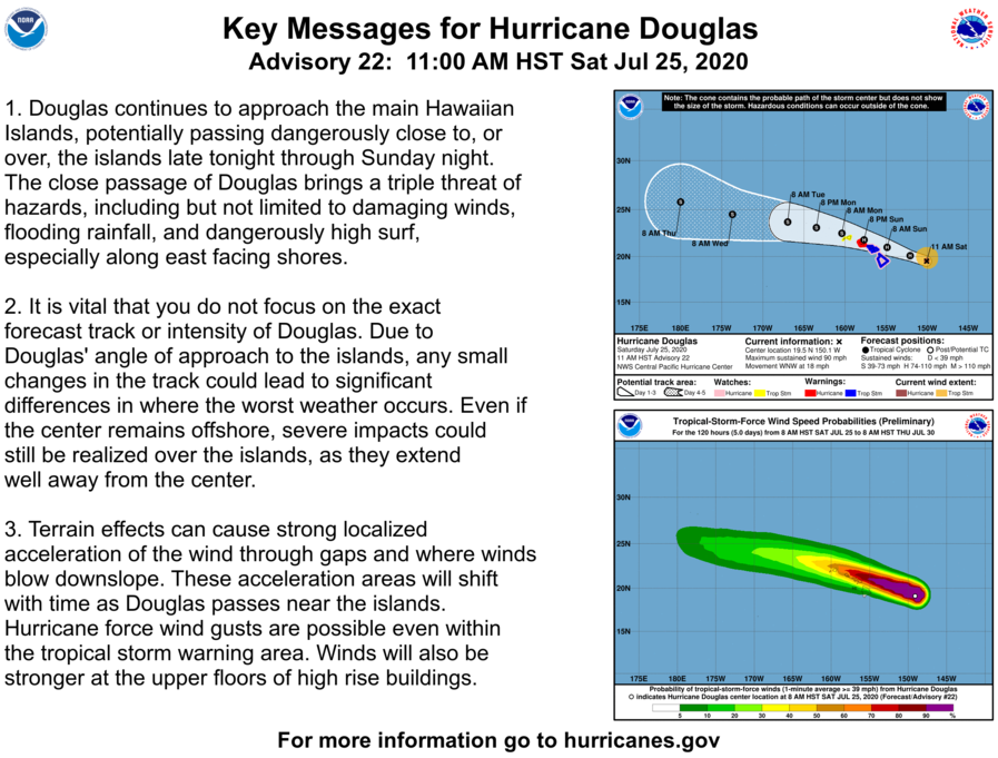
Douglas continues its approach to the Hawaiian islands, bringing with it the threat for damaging winds, heavy rainfall, storm surge, and dangerous swells beginning Sunday. A Hurricane Warning is currently in effect for the island of Oahu, while a Hurricane Watch is currently in effect for Hawaii county and Maui county, including the islands of Maui, Lanai, Molokai, and Kahoolawe. Additionally, a Tropical Storm Warning is in effect Hawaii county, Maui county, including the islands of Maui, Lanai, Molokai, and Kahoolawe, and Kauai county, including the islands of Kauai and Niihau. Also, a Tropical Storm Watch has been issued for portions of the Papahanaumokuakea Marine National Monument from Nihoa to French Frigate Shoals. Please refer to the Central Pacific Hurricane Center and your local National Weather Service office for more information regarding current watches and warnings in effect. Tropical storm conditions are expected to begin in portions of the warning area tonight, while hurricane conditions can be expected to begin on Sunday. Large swells generated by Douglas are expected to build tonight and affect the islands through Monday, and storm surge of up to 4 feet is expected near the center of the hurricane. Total rainfall accumulations of 5 to 10 inches are possible from Maui county westward to Kauai county, and accumulations of 2 to 5 inches are possible over Hawaii county. This rain may result in life-threatening freshwater and flash flooding and mudslides, particularly in mountainous terrain. Please continue to refer to the Central Pacific Hurricane Center and your local National Weather Service for further information regarding Hurricane Douglas.
External Links
Please refer to the National Hurricane Center and National Weather Service websites for further information regarding Hurricane Douglas as well as watches and warnings in effect. Force Thirteen will be providing live coverage on Hurricane Douglas through the weekend in addition to coverage on Atlantic Hurricane Hanna. More information can be found at Force Thirteen’s official outlets, including its Twitter and Facebook pages.
