Hurricane Erick Rapidly Intensifies; Flossie Becomes a Hurricane

With a small inner core and favorable environmental conditions present, Hurricane Erick rapidly intensified today as it entered the Central North Pacific. In just six hours, Erick intensified from a Category 1 hurricane with sustained winds of 80 mph (130 km/h), to a Category 3 hurricane with sustained winds of 115 mph (185 km/h), a 30-knot increase in that short period of time. Erick has continued to intensify and is currently a Category 4 hurricane with maximum sustained winds of 130 mph (215 km/h).
A favorable environment has also allowed Tropical Storm Flossie to strengthen into a hurricane today as it continues its westward track. Flossie is expected to remain in a generally favorable environment for strengthening over the next couple of days, which should allow the cyclone to intensify some. The National Hurricane Center (NHC)’s most recent forecast cone of uncertainty brings Flossie toward the Hawaiian islands over the weekend as a weakening cyclone; residents in the islands should closely monitor the progress of this tropical cyclone.
Current Storm Information
Hurricane Erick
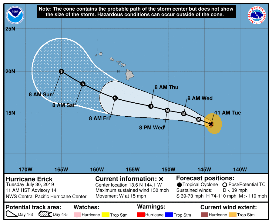
As of 11:00 AM HST (21:00 UTC), the center of Hurricane Erick was located near 13.6°N, 144.1°W, about 840 mi (1350 km) east-southeast of Hilo, Hawaii, or about 1050 mi (1695 km) east-southeast of Honolulu, Hawaii. Maximum sustained winds were 130 mph (215 km/h), gusting to 160 mph (260 km/h), and the minimum central pressure was 952 mb (28.12 inches). The hurricane was moving toward the west at around 15 mph (24 km/h), and a slight turn to the west-northwest with a decrease in forward speed is forecast to begin today and continue through Thursday. Although powerful, Erick is a relatively small hurricane. Hurricane-force winds extend outward up to 25 miles (35 km), and tropical storm-force winds extend outward up to 105 miles (165 km) from the center of Erick. Erick has another 24 hours or so to intensify in a favorable environment, and the Central Pacific Hurricane Center (CPHC) forecasts some additional intensification before the cyclone encounters strong vertical wind shear, which should prompt a rapid weakening trend. Erick is forecast to weaken below Category 3 hurricane strength by Thursday, and weaken below hurricane strength by Friday as it passes south of the Hawaiian islands, likely degenerating into a remnant low by the end of the week.
Hurricane Flossie
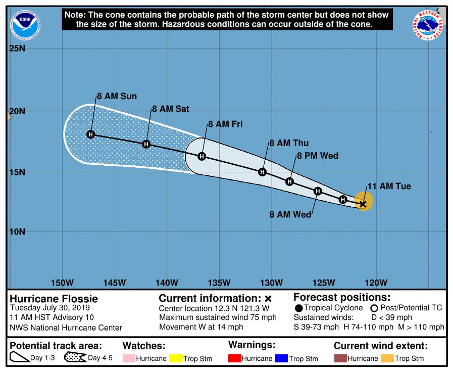
As of 11:00 AM HST (21:00 UTC), the center of Hurricane Flossie was located near 12.3°N, 121.3°W, about 1045 mi (1685 km) southwest of the southern tip of the Baja California Peninsula. Maximum sustained winds were 75 mph (120 km/h), gusting to 90 mph (150 km/h), and the minimum central pressure was 995 mb (29.39 inches). The hurricane was moving toward the west at 14 mph (22 km/h), and this general motion is expected to continue during the next few days. Hurricane-force winds extend outward up to 25 miles (35 km), and tropical storm-force winds extend outward up to 80 miles (130 km) from the center of Flossie. The environment should remain favorable for further intensification during the next couple of days, and the NHC forecasts Flossie to become a Category 2 hurricane Wednesday evening. After that time, sea surface temperatures will begin to decrease and wind shear will begin to increase, which should induce a slow weakening trend. It is worth noting that the official forecast cone brings Flossie in the direction of the Hawaiian Islands at the end of the forecast period, a situation which is depicted by both the GFS (American) and ECMWF (European) models.
Potential Impact to Hawaii
Swells generated by Hurricane Erick are expected to reach the Hawaiian islands and persist during the next couple of days. These swells could produce dangerous surf conditions, especially along east-facing shores, and generate dangerous rip currents. Please consult products from the CPHC and the National Weather Service (NWS) in Honolulu for more information about the situation with Hurricane Erick.
Although it is too soon to determine if Hurricane Flossie may impact the Hawaiian islands, now would be a good time for everyone in the islands to ensure that they have a hurricane plan in place. Both the GFS and ECMWF models, as well as a majority of the ensemble members, show Flossie impacting the Hawaiian islands as a weakened storm at the end of the week and into the weekend. Even though Flossie is likely to have weakened significantly by that time, the cyclone could produce heavy rainfall and generate strong winds in the islands. Tropical cyclones affecting Hawaii have the potential to produce very heavy rainfall due to the topography of the islands. Heavy rainfall can cause flash flooding and mud slides, which can pose a significant threat to life and property. Recently, in August 2018, Hurricane Lane produced torrential rainfall in Hawaii, particularly on the Big Island, which set rainfall records for the state of Hawaii and made it one of the wettest tropical cyclones on record in the United States. Although a rainfall event as extreme as that caused by Lane is not particularly likely, heavy rainfall is likely to be a significant threat if Flossie does impact the islands.
For more information regarding current activity in the tropics, visit Force Thirteen’s official outlets. Live updates and daily Tropical Weather Bulletins can be found at the official Force Thirteen YouTube channel, and further information can be found on the Force Thirteen Twitter and Facebook pages.
