Hurricane Ian rapidly intensifying, with Cuba and Florida on the crosshairs

Hurricane Ian continues to improve and generate deep convection this morning, with the NHC forecasting a major hurricane to hit Cuba and threaten the state of Florida.
Current Information
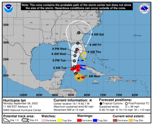
As of 11am Eastern Standard Time, Hurricane Ian is located at 19.1 degrees north and 82.7 degrees west, or about 100 miles west of Grand Cayman, with maximum sustained winds of 80 mph (130 kph), with gusts up to 100 mph (155 kph), and a central pressure of 980 millibars. The storm is currently moving northwest at 13 mph (20 kph).
Current Warnings
A Hurricane Warning, meaning hurricane conditions are expected somewhere within the warning area, in this case within 24 to 36 hours, is in effect for:
- Grand Cayman
- Cuban provinces of Isla de Juventud, Pinar del Rio, and Artemisa
A Tropical Storm Warning, meaning tropical storm conditions are expected somewhere within the warning area within 36 hours, is in effect for:
- Cuban provinces of La Habana, Mayabeque, and Matanzas
- Lower Florida Keys from Seven Mile Bridge westward to Key West
- Dry Tortugas
A Storm Surge Watch, meaning there is a possibility of life-threatening inundation, from rising water moving inland from the coastline, in the indicated locations during the next 48 hours, is in effect for:
- Florida Keys from the Card Sound Bridge westward to Key West
- Dry Tortugas
- Florida Bay
- Anclote River southward to the Card Sound Bridge
- Tampa Bay
A Hurricane Watch, meaning hurricane conditions are possible within the watch area, generally within 48 hours, is in effect for:
- Englewood to the Anclote River, including Tampa Bay
A Tropical Storm Watch, meaning tropical storm conditions are possible within the watch area, generally within 48 hours, is in effect for:
- Little Cayman and Cayman Brac
- Englewood southward to Flamingo
- Florida Keys from Seven Mile Bridge to the Channel 5 Bridge
- Lake Okeechobee
Current Forecast
Ian is set to continue rapid intensification as it turns north-northwest, and become a major hurricane by tomorrow as it reaches western Cuba. From there, the hurricane is forecast to peak in the Gulf of Mexico as a Category 4 on the Saffir-Simpson scale, with winds of 140 mph (220 kph), before weakening into a Category 2 due to a combination of strong southwesterly shear and dry air, and hit Florida with the same intensity. The storm is then forecast to weaken into a tropical storm as it moves inland.
Current Hazards
Life-threatening storm surge, hurricane-force winds, flash floods and possible mudslides are the main hazards for Ian as the aforementioned threats are expected in portions of western Cuba beginning this evening and continuing into Tuesday. Devastating wind damage is possible where the core of Ian moves across western Cuba.
Hurricane-force winds are possible in the hurricane watch area in west-central Florida beginning Wednesday morning with tropical storm conditions possible by late Tuesday.
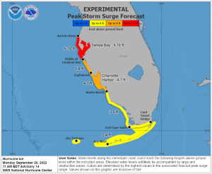
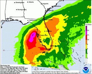
Multiple rounds of heavy rainfall associated with rainbands may lead to flooding across all of South Florida. Rainfall totals may range 3 to 8 inches through Thursday with locally higher amounts possible, and the risk could extend later into the week. This may result in significant flooding impacts. Peak storm surge values of 3 to 5 feet are possible along the Southwest Florida coast mainly between Tuesday night and Wednesday night. This could lead to significant and life-threatening storm surge flooding.
Tornadoes may be embedded in showers and thunderstorms within the outer rainbands associated with the system. Main concern is from tonight through Wednesday. Hazardous marine and beach conditions are expected with a high risk for rip currents across all South Florida beaches. Elevated surf conditions are expected along the Gulf coast.
Stay safe from this storm, and listen to local officials for recommended preparedness actions, including possible evacuation. If ordered to evacuate, do so immediately. Force Thirteen will be live this afternoon, and you can watch it through here:
