Hurricane Iota To Strike Nicaragua Close To Category 5 Intensity

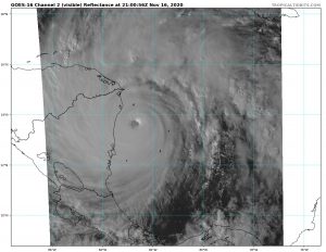
Hurricane Iota on visible satellite earlier today, courtesy of tropicaltidbits.
As of the last National Hurricane Center forecast, advisory 14, Hurricane Iota is a Category 5 hurricane with windspeeds of 160mph(260km/h) and a pressure of 919 millibars, and has levelled off for now based on recon data. The NHC is now forecasting a Category 5 landfall in Nicaragua, almost exactly where Eta made landfall just 2 weeks prior.

The storm is less than 12 hours from landfall, and all preparations should be rushed to completion as immense winds, storm surge, and rainfall are about to hit the east coast of Nicaragua. At this point, the landfall intensity is very likely constrained to windspeeds above 130mph(210km/h) and impacts will undoubtedly be catastrophic. Force Thirteen has rated the system at a CDPS Stage 9, almost the highest value on the scale, corresponding to extreme and widespread damage. Keep in mind that there is still room for strengthening and impacts could still be worse than currently projected. The wind field of the system has also increased recently based on recon data.
Currently, the system is at 13.6N 82.7W and hurricane force winds are just offshore. Hurricane force winds constitute winds of at least 64kts. In better news, Providencia is on the outgoing side of the system and is likely to experience relatively little additional impacts. Returning to the imminent landfall at hand, again, Nicaragua and Honduras have already suffered from the impacts of Hurricane Eta and that system’s leftover meteorological impacts will exacerbate Iota’s impacts there as well. This situation is unprecedented as no 2 major hurricanes have hit Nicaragua in the same year, much less 2 systems over Category 4 intensity. The damage can be assumed to be extreme and most likely will be, with 30 inches of rainfall projected over already saturated areas.
At this point, the preparation phase has ended and the warnings and watches are no longer terribly useful, so they will not be listed. Conditions will deteriorate very quickly throughout the evening in areas near landfall, while areas farther away will experience extended winds and severe rainfall. Again, this is a Category 5 hurricane that will destroy most, if not all structures that are not designated storm shelters. Take shelter in one of these storm shelters, preferably one of concrete or metal construction with no areas open to the environment.
Again, listen to local officials and the NHC for final information on your course of action. Evacuation would be unadvisable at this time due to highly unfavorable conditions. Stay tuned for more updates on the progress of the system and, most importantly, stay safe.