Hurricane Iota Currently Landfalling At Near Category 5 Strength

Hurricane Iota is currently making landfall with winds of 155mph(250km/h) per the latest NHC forecast, Advisory 15.
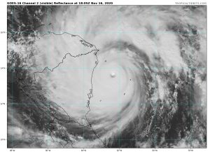
As of the latest National Hurricane Center forecast, Advisory 15, Hurricane Iota is a 155mph(250km/h) major hurricane currently in the process of landfalling on the eastern coast of Nicaragua. The pressure of the system is 920mbar, and portions of Nicaragua are currently suffering extremely severe conditions. Hurricane Iota will landfall less than 20 miles away from where Hurricane Eta made landfall 2 weeks ago.
Again, the system is currently impacting portions of Nicaragua with major hurricane force winds of 100 knots or above. Due to its high intensity, storm surge and winds are catastrophic, while massive amounts of rain from Iota’s accumulated moisture is being dumped over already saturated areas. Puerto Cabezas airport in Nicaragua has reported 70mph(113km/h) sustained winds over 50 kilometers from the center, while hurricane force winds extend 75 miles from the center. This may seem contradictory, but remember that the sparse reporting network in Nicaragua means severe undersampling of winds, so the severe conditions do extend rather far from the center. Force Thirteen’s CDPS scale rates Hurricane Iota as a Stage 9, expecting extreme and widespread damage from multiple factors. The most important of these factors is the rainfall totals, forecast to be over 30 inches, which can cause widespread flooding and landslides. This threat is again exacerbated by Hurricane Eta’s effects on the area not long ago.
Warnings and watches will not be listed due to those impacts being currently occurring. Tropical storm force winds encompass most of the east coast of Nicaragua and some portions of the northern Honduran coast, while hurricane force winds are restricted to a smaller portion of the coast near Puerto Cabezas in Nicaragua. The conditions are currently changing as the system moves inland, and the eastern coast of Nicaragua will face an extended period of gale-force winds while more portions of the northern Honduran coast will be experiencing those gale-force winds imminently.
Storm surge is currently forecast to peak at around 15-20 feet, or 5-6 meters. This will undoubtedly be catastrophic for coastal areas as the storm surge floods land areas and destroys property. These impacts are currently being felt in Central America and we can only hope that we will not have a humanitarian disaster on our hands in the coming days. This is a truly unprecedented situation, with the latest Category 5 in Atlantic History striking an area near peak as the most intense Nicaraguan landfall in history within two weeks of another major hurricane landfall. And while it is down from its peak as a Category 5 hurricane, impacts are still catastrophic and the weakening should not change your decisions about anything storm related.
Please listen to your local officials for the latest information. Stay tuned for more updates on the situation, and please, please, stay safe.
