Hurricane Iota moving inland as a catastrophic category 4 hurricane, forecast to weaken soon

Hurricane Iota has now made landfall near the town of Haulover in Nicaragua, and is expected to rapidly weaken soon.
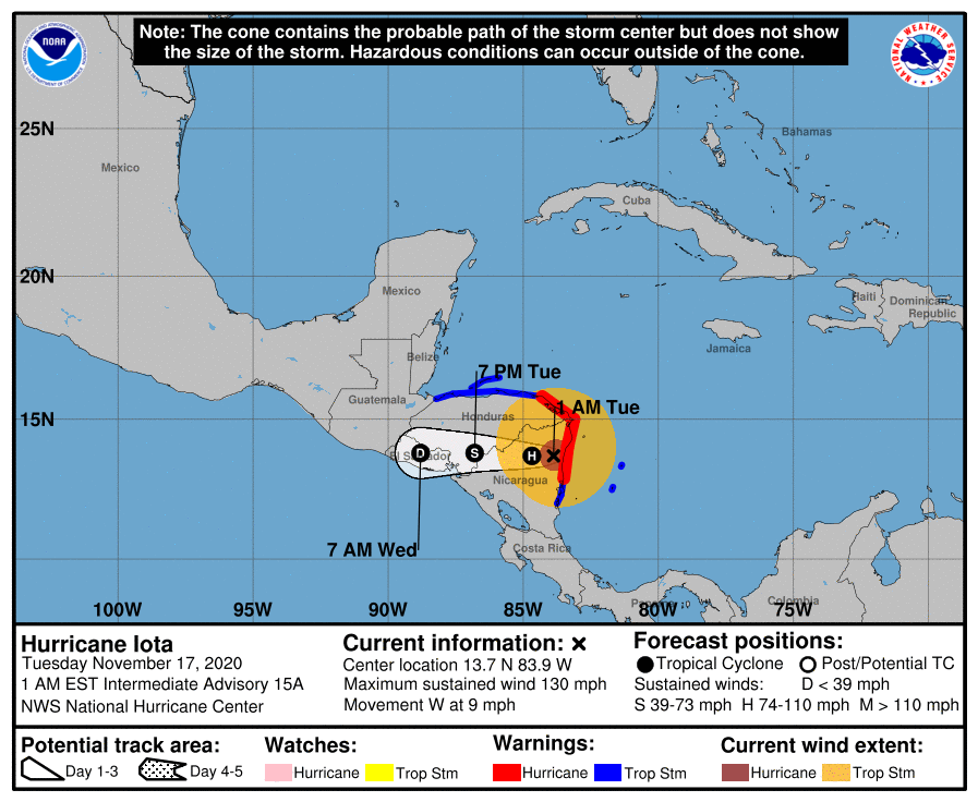
Iota is located at 13.7 degrees north, 83.9 degrees west, at about 40 miles southwest of Puerto Cabezas in Nicaragua, and about 105 miles south-southwest of the town of Cabo Gracias a Dios on the Nicaragua/Honduras border. The storm has maximum sustained winds of 130 mph and a minimum central pressure of 935 millibars. The storm is now weakening due to the whole center of said system is now over the mountainous terrains of Nicaragua. The storm is currently moving west at 9 mph.
What warnings are in effect for this storm?
Currently, a Hurricane Warning, which means that hurricane conditions are expected somewhere within the warning area, is in effect for:
- The coast of Nicaragua from the Honduras/Nicaragua border to Sandy Bay Sirpi, and
- the coast of northeastern Honduras from Punta Patuca to the Honduras/Nicaragua border.
A Tropical Storm Warning, which means that tropical storm conditions are expected somewhere within the warning area within 36 hours, is also in effect for:
- Providencia,
- San Andres,
- the coast of Nicaragua from south of Sandy Bay Sirpi to Bluefields,
- the northern coast of Honduras from west of Punta Patuca to the Guatemala/Honduras border, and the
- Bay Islands.
What kind of conditions are to be expected from Iota?
- A life-threatening storm surge will raise water levels by as much as 10 to 15 feet above normal tide levels in areas along the coast of Nicaragua and Honduras.
- Catastrophic wind damage is occurring near Iota’s eyewall and these winds will spread farther inland across northern Nicaragua during the next several hours.
- Iota is expected to dump 10 to 20 inches (250 to 500 mm) of rain, with isolated maximum totals of 30 inches (750 mm), across northeast Nicaragua and northern Honduras. El Salvador and Panama could get 6 to 10 inches (150 to 250 mm) of rain, with isolated maximum totals of 15 inches (380 mm), from Iota. These kind of rainfall can lead to significant, life-threatening flash flooding and river flooding, along with mudslides in areas of higher terrain.
- Southern Nicaragua and Costa Rica could get 3 to 5 inches (75 to 125 mm) of rain, with isolated maximum totals of 10 inches (250 mm) from this storm.
Please be prepared for this storm, as right now, it is again moving from Haulover, which in the earlier days got struck by Hurricane Eta. Please be safe for this storm, keep updated with your local officials, and evacuate if needed to. Stay tuned for updates.
References:
- The National Hurricane Center’s special statement of Iota making landfall: https://www.nhc.noaa.gov/archive/2020/al31/al312020.update.11170347.shtml?
- The National Hurricane Center’s intermediate advisory #15A for Iota: https://www.nhc.noaa.gov/archive/2020/al31/al312020.public_a.015.shtml?

Now lota is a cat 4