Hurricane Laura Makes Potentially Catastrophic Landfall in Southwestern Louisiana

Hurricane Laura has made landfall near Cameron, Louisiana, as a potentially catastrophic Category 4 hurricane tonight. At 1:00 AM CDT (06:00 UTC August 27), the center of the eye of Hurricane Laura moved onshore near Cameron, Louisiana. Maximum sustained winds at landfall were 150 mph (240 km/h), with gusts of up to 185 mph (295 km/h) and the minimum central pressure was 938 mb (27.70 inches). Below is the latest information on Hurricane Laura, as well as external links to Force Thirteen’s live coverage on Laura and official information from the National Hurricane Center (NHC) and the National Weather Service (NWS).
Hurricane Laura: Current Storm Information
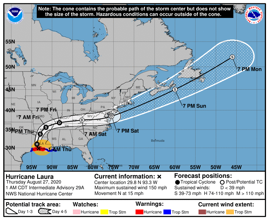
As of the National Hurricane Center’s most recent advisory on Laura at 1:00 PM CDT (06:00 UTC), Doppler radar data indicated that the center of the eye of Hurricane Laura has made landfall near Cameron, Louisiana, near 29.8°N, 93.3°W. Laura is currently located about 30 mi (45 km) south-southwest of Lake Charles, Louisiana, and about 40 mi (70 km) east of Port Arthur, Texas. Maximum sustained winds are near 150 mph (240 km/h) with gusts to 185 mph (295 km/h) and the storm’s minimum central pressure is 938 mb (27.70 inches). Tropical storm-force winds extend outward up to 205 mi (335 km) from the center, and Hurricane-force winds extend outward up to 60 mi (95 km) from the center. Laura is moving toward the north at around 15 mph (24 km/h), and this motion should continue through today. A northeastward and then east-northeastward motion is expected to begin tonight and Friday. On the NHC’s forecast track, the center of Laura will continue to move inland over Louisiana through this afternoon, move into Arkansas tonight, over the Mississippi Valley on Friday, and into the Mid-Atlantic states on Saturday. Laura is forecast to weaken quickly as it moves inland, but is expected to remain a hurricane through the afternoon, and a tropical storm through Friday evening. By Saturday, Laura is forecast to become post-tropical as it accelerates northeastward toward the western Atlantic.
Key Messages and Hazards Affecting Land
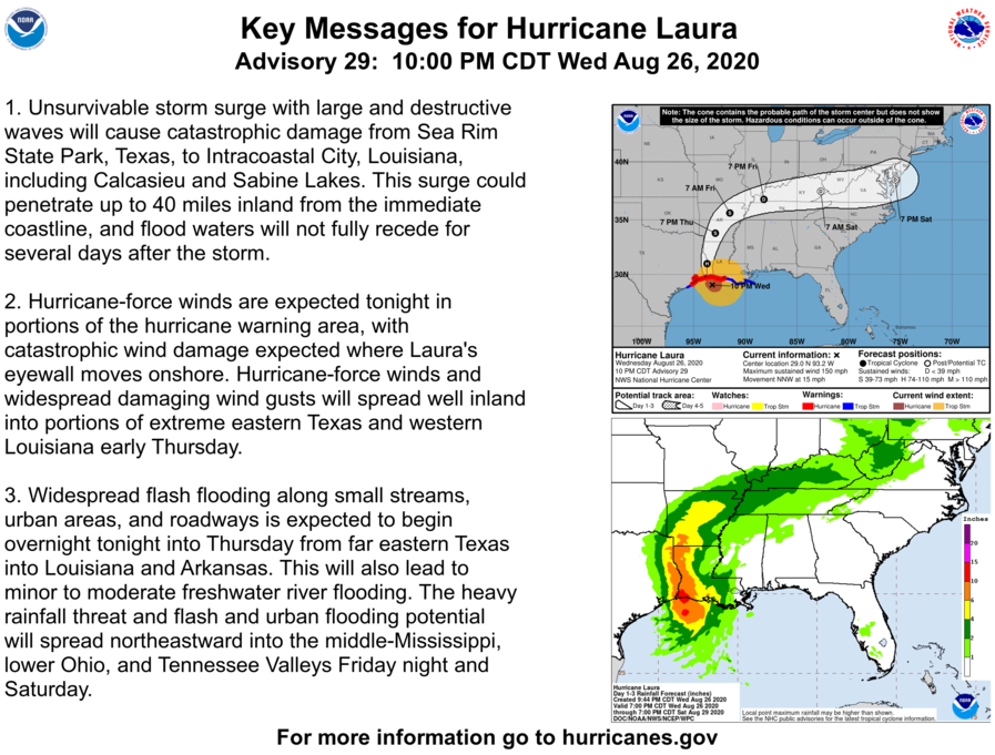
Extremely dangerous winds associated with the eyewall of Laura are moving onshore in southwestern Louisiana, accompanied by an extremely dangerous storm surge and heavy rainfall. This is a LIFE-THREATENING situation, and anyone caught in the core of Laura should take shelter immediately. Move to higher ground and shelter in an interior room of a building to protect yourself from rapidly-rising water and extreme winds. These extremely dangerous conditions are occuring across a large area from Port Arthur, Texas, to Rockefeller Wildlife Range in Louisiana. Unsurvivable storm surge, with peak surge heights of 15 to 20 feet from Johnson Bayou to Rockefeller Wildlife Range and with significant surge heights of up to 3 feet and greater occuring as far east as the mouth of the Misssissippi River and as far west as Galveston Bay. This dangerous storm surge could extend as far as 40 miles (70 km) inland, and waters may not recede for several days after the storm has passed.
Hurricane Warnings are currently in effect for much of southwestern Louisiana and extreme eastern Texas, with Tropical Storm Warnings extending eastward into southeastern Louisiana, westward into eastern Texas, and northward into southern Arkansas. Hurricane conditions are expected within the warning area through the morning, with tropical storm conditions spreading northward within the warning area through the day. Total rainfall accumulations of 2 to 12 inches are anticipated across Laura’s projected track, with the greatest amounts expected in western Louisiana, eastern Texas, and southern and central Arkansas. This heavy rainfall may lead to widespread freshwater and flash flooding, as well as rapid rises in small streams, creeks, and rivers. Additionally, there is a significant risk for tornadoes across much of Louisiana, southeastern Texas, and southwestern Mississippi through today in association with Laura, and continue throughout the day, extending into southern Arkansas. Large swells produced by Laura are expected to continue across much of the U.S Gulf Coast through today, and are likely to cause life-threatening surf and rip current conditions. Continue to refer to the National Hurricane Center and your local NWS office for the latest information on Hurricane Laura.
External Links
Please refer to the National Hurricane Center and National Weather Service websites for further information regarding Hurricane Laura as well as watches and warnings in effect. Force Thirteen is currently providing live coverage on Laura on the Force Thirteen YouTube channel at: https://www.youtube.com/watch?v=liaqfwJ20zE, and will continue to do so as conditions warrant. More information can be found at Force Thirteen’s official outlets, including its Twitter and Facebook pages.
