Hurricane Michael: Category 4 or Category 5?

Hurricane Michael was an extremely violent hurricane that struck the Panama City, Florida, area on October 10, 2018, as a category 4 hurricane. The storm is currently blamed for about 60 fatalities and more than $10 billion in damages, mainly in Florida, but also extending up into Georgia, the Carolinas, and Virginia. Many coastal towns, such as Mexico Beach, were utterly devastated by the hurricane’s extreme winds and storm surge. Michael was the most powerful hurricane to ever strike Florida Panhandle on record, the third most intense to hit the continental United States, and the strongest hurricane to ever make landfall during October since the HURDAT era began in 1851. But exactly how strong was it?

Officially, Michael peaked (and made landfall) with wind speeds of 135kts, or 155mph, and a minimum central pressure of 919mb. This ranks the storm on the upper-end of category 4 on the Saffir-Simpson Hurricane Wind Scale. If the storm’s winds were about 2kts higher, Michael would rank as a category 5, the highest ranking on the scale. So naturally, when a storm is this close to reaching such a feat, storm trackers like to go in-depth into the storm to see whether or not it truly was a category 5 or not. There exist factors that may either prove or debunk the thought of Michael being a category 5 hurricane.
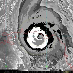
One of the first things may storm trackers use to analyze a storm’s intensity is satellite imagery, more specifically infrared satellite imagery. There’s no question that Michael’s satellite presentation was incredible, but was it good enough for category 5? Dvorak imagery is one method to use when determining intensity, and is usually considered the most accurate. For Michael’s peak satellite presentation (1645 UTC 10 Oct), the storm features cold-medium gray cloud tops within the southern CDO and an eye temperature near +9C. Subjective Dvorak estimates for Michael reached T6.5, or about 127kts, and the CIMSS ADT value reached T7.2, or about 145kts. However, ADT is used more for real-time analysis, and many data points are considered erroneous based on exact center positioning. Using this, satellite estimates suggest that Michael was a 130-135kt hurricane, comfortably within the category 4 range.
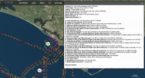
However, satellite observations were not the only thing readily available to us to analyze Michael’s intensity. Because the storm was approaching landfall, aircraft reconnaissance intersected the center of the hurricane dozens of times throughout the day. The planes recorded wind and pressure data during their flights, giving us direct observations into the storm. The final mission into Michael was from AF301 from the US Air Force, which flew into Michael upon landfall, observing maximum flight level winds of 151kts, or about 175mph, within the southeastern quadrant. Generally, the northeastern quadrant is the strongest part of the storm, but because this part of the storm was already over land at the time, the plane was not allowed to measure wind speeds there (and winds at the surface would not have been any stronger because of frictional forcing on land). In addition, the plane released a dropsonde into the center of Michael’s eye, recording pressure and wind data along the way. The dropsonde itself recorded a minimum surface pressure of 922mb with a wind speed of 34kts, meaning that it missed the exact center. When extrapolating this data, it is likely that the pressure within the exact center was 919mb +/-1mb. Because there is no set adjustment for flight level winds to surface winds, it is difficult to determine the surface winds based on this data. However, SFMR surface readings recorded 120kt winds, but these are generally considered to be too low based on all other data observed, likely due to proximity to land.
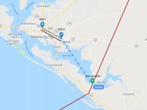
Another thing we can use to determine the strength of Michael is to observe what happened on the ground. This can vary from storm chaser observations to damage surveys. Storm chaser Josh Morgerman recorded a pressure of 939.7mb in central Panama City, which was just 3.7nmi away from a 923.2mb reading in Callaway, which was located in the western edge of the eye at the time. Both observations were taken at 1745 UTC Oct 10. Pressure gradience always decreases by a factor of 4 within the eye, which was about 9.4nmi away from the exact center of the hurricane. This would mean that the exact center pressure was likely near 917mb, 2mb lower than the operational NHC number.
The last thing we can use to get a grip on the true wind speed is damage assessments. In a case like this, the damage from the hurricane can be used to determine how strong the winds could have been, similar to how a tornado’s top wind speeds within a certain area are estimated. At this time, there have yet to be any damage surveys publicly released, but using a subjective view at images from Mexico Beach, where the winds were estimated to have been the highest, it’s safe to say that maximum sustained winds were likely somewhere between 130 and 145kts, equivalent to that of a high end EF4 tornado. This range is so wide because there exists uncertainty with the exact winds due to the lack of any official estimates. This estimate is subjective, however.
In conclusion, I believe that the most likely outcome was that Michael reached maximum sustained wind speeds of 138kts, which barely reaches the threshold for category 5. However, we will not have a definitive number from the NHC until they release their Tropical Cyclone Report on the storm during early 2019. Regardless of whether or not it was a category 4 or 5, Michael was a truly historic storm that will be in the minds of storm trackers and Floridians for years or decades to come.

I think that Hurricane Michael reached high end category four peak right before landfall, this hypothesis have been accepted by National Hurricane Center and The Weather Channel because terrain of Florida Panhandle actually blocked its intensification towards the later stage of category five as the system’s heat generator had cut off and it’s wind, surge and torrential rain blocked by the mountainous terrain. The intensity of the storm system must recorded within these circumstances (surge, wind, rain, damages and its structure and wind radii) where we can classify Hurricane Michael to category five or not.