Hurricane Michael Officially Upgraded to a Category 5 Hurricane

Hurricane Michael seen by the GOES-16 satellite minutes before reaching its peak intensity on October 10, 2018. Courtesy of the National Oceanic and Atmospheric Administration (NOAA)
Today, the National Hurricane Center NHC released its post-season analysis of Hurricane Michael, determining that the cyclone was a Category 5 hurricane (On the Saffir-Simpson Hurricane Wind Scale) at the time of its catastrophic landfall on the Florida panhandle near Tyndall Air Force Base and Mexico Beach on October 10, 2018. The NHC published its final analyses in its Tropical Cyclone Report on the hurricane, which contains a meteorological summary of the storm and a detailed analysis of intensity and damage statistics.
The upgrade of Michael to a 140 knot (160 mph) Category 5 hurricane from an operational estimate of 135 knots (155 mph) marks several records. First, Michael is the first Category 5 hurricane to make landfall in the continental United States since Hurricane Andrew in 1992, as well as one of only four on record, including the Labor Day hurricane of 1935, Hurricane Camille of 1969, and the aforementioned Hurricane Andrew of 1992, to do so. With a barometric pressure of 919 millibars at landfall, Michael is the third-most intense hurricane to make landfall in the continental United States, trailing the Labor Day hurricane of 1935 (892 millibars), and Hurricane Camille of 1969 (900 millibars). With landfall occurring at 18:00 UTC on October 10, Michael marked the latest Category 5 hurricane landfall in the continental United States on record. Additionally, attaining Category 5 hurricane intensity at 30 degrees north longitude, Michael became a Category 5 hurricane farther north than any other Atlantic hurricane in the reliable record.
But how exactly was the intensity of Hurricane Michael estimated? A variety of methods, ranging from satellite intensity estimates to real-time measurements were all taken into consideration in the final analysis of the hurricane.
Estimating Intensity
The National Hurricane Center estimated the maximum intensity of Hurricane Michael using a variety of methods and measurements. Aircraft Reconnaissance provided valuable real-time measurements of the hurricane’s winds and pressure, flying into the strongest region of the hurricane: the eyewall and eye itself. The maximum flight-level wind speed recorded by aircraft was 152 knots (175 mph) at 8,000 feet (2,438 meters) above sea level in the southeastern eyewall at 17:23 UTC on October 10. As winds at higher altitudes are stronger than those at sea level, the NHC used reduction techniques to estimate the surface winds in the area at 137 knots (158 mph), just above the threshold of Category 5 status. The maximum surface wind estimate by aircraft was 138 knots (159 mph) in the southern eyewall at 17:06 UTC on October 10. These values all support Category 5 hurricane status at the Florida landfall.
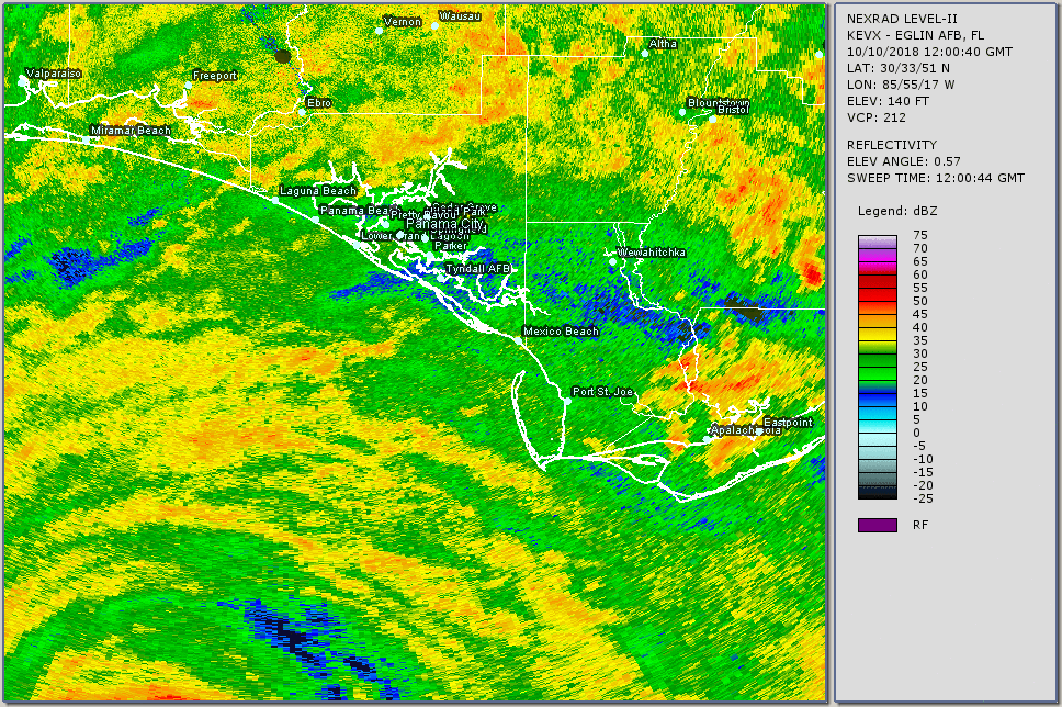
Doppler radar measurements also proved valuable in measuring the peak intensity of Michael. The NHC analyzed data from the radar station in Eglin AFB, Florida (KEVX) WSR-88D during the final hours leading up to the hurricane’s landfall. The wind velocities measured by the radar were adjusted by meteorologists at the center to be comparable with aircraft measurements. The radar measured winds of up to 149 knots (171 mph), and averaging multiple measurements from the time of landfall suggested peak winds of 145 knots (165 mph). However, the NHC considered these measures to be questionable, as small errors in wind direction could create a high bias in radar velocity measurements. Doppler radar data indicated that stronger winds existed just to the northeast of the flight path of the aircraft which measured the strongest winds, suggesting that the aircraft did not sample the strongest winds in Michael’s eyewall. Other surface measurements were also available from Tyndall Air Force base and two Florida Coastal Monitoring Program (FCMP) towers. These stations reported maximum sustained winds less than 100 knots (115 mph), and likely did not sample the maximum winds of the hurricane. The Tyndall Air Force station measured a peak gust of 121 knots (139 mph), while one FCMP tower on the premises of Tyndall Air Force Base reported a gust of 112 knots (129 mph). Both stations were knocked down during the passage of the strongest winds.
Lastly, additional intensity estimates came from wind-pressure relationships and various satellite intensity estimate. Michael’s minimum barometric pressure of 919 millibars at landfall equated to an intensity of 142 knots (163 mph) through relationships associated with the Dvorak technique, which is used to estimate tropical cyclone intensity through visual patterns and appearance noted on satellite imagery. Another wind-pressure relationship used in Atlantic hurricane re-analysis of intensifying hurricanes north of 25°N yielded an intensity of 139 knots (160 mph). Finally, the Knaff-Zehr-Courtney relationship using the central pressure and other measurements yielded 140 knots (161 mph). Satellite intensity estimates from the Dvorak technique peaked at 140 knots (161 mph), while those based on the Cooperative Institute for Meteorological Satellite Studies (CIMSS) Advanced Dvorak Technique were slightly higher, at 140–145 knots (161–167 mph). Estimates from microwave-derived techniques were lower, at 110–135 kt (127–155 mph). Although uncertainty in Michael’s peak intensity exists, the final analysis from the National Hurricane Center places Michael in the record books as a Category 5 hurricane. Further re-analysis of the hurricane is ongoing, and revisions to the final landfall intensity estimate are possible. The complete Tropical Cyclone Report on Hurricane Michael can be found here: https://www.nhc.noaa.gov/data/tcr/AL142018_Michael.pdf.
Lessons From the Storm
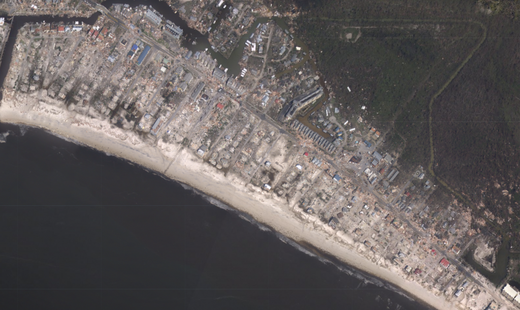
Michael inflicted over $25 billion (USD) in damages along its path from Central America and Cuba to the Southeastern United States. The powerful hurricane’s winds and storm surge caused catastrophic damage in western Florida, particularly in the small community of Mexico Beach, which was almost completely destroyed. Buildings and numerous military aircraft at Tyndall Air Force base were damaged or destroyed, and $3 billion in damages is attributed to damage at Tyndall Air Force base. Damage continued as far inland as southern Virginia. A total of 59 deaths were attributed to Michael in the United States as a result of both direct and indirect effects of the hurricane. Of the $25 billion total damages in the United States, $18.4 billion occurred in Florida, $4.7 billion occurred and Georgia, and $1.1 billion occurred in Alabama. The remaining damages occurred in the South Carolina, North Carolina, and Virginia, where relatively minor damage occurred from flooding caused by a weakening Michael. The precursor disturbance that spawned Michael also produced heavy rains in Central America, with 15 deaths reported. Monetary damage estimates from Central America and Cuba, which were also affected by Michael, are not available at this time.
The disaster inflicted upon Florida and the Southeastern United States by Hurricane Michael serves as a reminder to the destructive potential of nature. As with storms before it, we have learned through Michael not to take tropical cyclones lightly, and to always be prepared for when disaster strikes. Tropical cyclones can bring some of the most dangerous forces on Earth with them, including strong winds, flooding, and storm surge, all of which are capable of producing severe damage and loss of life and property. Thanks to the tireless work of forecasters, modern warning systems, and live broadcasting, tropical cyclone preparedness is better than it has been ever before, and work is underway to increase tropical cyclone awareness and preparedness around the globe. As we continue to monitor and research tropical cyclones, we continue to gain a better understanding of the greatest storms on Earth.
Acknowledgments
Special thanks to Hank Dolce for providing context and data on Hurricane Michael. An article regarding intensity analysis of Michael can be found here: https://www.force-13.com/2018/10/29/hurricane-michael-category-4-or-category-5/
