Ice Storm Strikes Kentucky and Along Parts of the Lower Mississippi River

An IR image of the system causing adverse effects across much of Kentucky and parts of the Lower Mississippi River. Courtesy of TropicalTidbits
An Ice Storm Warning now encompasses most of Kentucky and parts of the Lower Mississippi River, according to the National Weather Service. A graphical depiction of afflicted areas is shown on
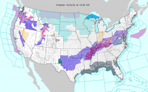
the right. Most of Eastern, Central, and all of Western Kentucky is within the Ice Storm Warning area, with the rest of Kentucky, limited to the northern portion, within Winter Storm Warnings. Almost all of Kentucky is forecast to remain below freezing through at least Thursday night. Ice Storm Warnings across the areas are forecast to stay in place until Thursday afternoon, including the areas in Tennessee, Arkansas, Missouri, and Mississippi. Ice Storm Warnings currently in effect are the result of expected significant icing across the area within the warnings. Icing is a result of the precipitation of freezing rain, and can make traversing any type of terrain difficult and dangerous to both life and property.
Within the Ice Storm Warning, ice is likely to accumulate on all surfaces open to precipitation, resulting in possible damage to power lines and trees if accumulation is excessive. Ice accumulation damage has already occurred across Kentucky, so power outages are possible if you live within the warning area. For the most local and specific information go to the National Weather Service and select your local NWS Forecast Office. There you will find specific estimates on how your area will be affected by the current winter weather.
