Invest 92L Likely to Be Named by Thursday — Potentially Serious Threat to Louisiana and Texas

Key Points:
- Invest 92L is likely to become a tropical cyclone within the next 24 to 48 hours.
- It is likely to become a tropical storm, and at that point will be named Barry.
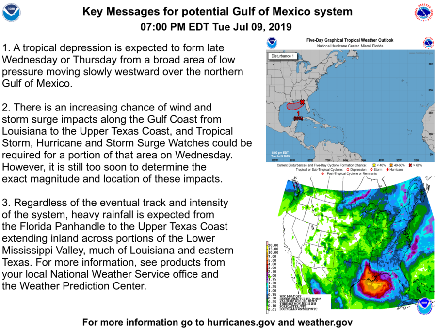
- 92L poses a serious threat to Louisiana and Texas, with a hurricane landfall predicted by most models.
- The expected peak is predicted to be a mid-grade category 1 hurricane, although further intensification is possible.
- If designated, Barry will be the first storm in the basin since Andrea in May.
- If a hurricane landfall occurs, it will be the first July hurricane landfall in the CONUS since Arthur in 2014.
GULF COAST — Invest 92L emerged into the Gulf of Mexico this morning, and signs of organization have already begun. Although the invest remains fairly disorganized at its core, strong convection has sprouted around the low-level center. The National Hurricane Center (NHC) expects fairly rapid development, with a 90% chance of tropical cyclone formation in the next 48 hours.

The general intensity model consensus is that the storm, if it does develop, will peak as a strong tropical storm or weak category 1 hurricane prior to landfall, before weakening as it begins to move inland near the Louisiana/Texas border. The track still remains somewhat uncertain, however. Models continue to shift westwards and eastwards with landfall location, although the general consensus today has been a central Louisianan landfall, rather than the eastern Texas solution shown by most major models yesterday.
Although the storm may form soon, intensification is not shown by most models until the storm is approaching landfall. The most aggressive of the hurricane models as of the 18z run is the HWRF, which rapidly intensifies 92L into a powerful 125 mph category 3 hurricane moving inland into central Louisiana. However, this is quite unlikely, and most models, such as the GFS and HMON, show a weak hurricane landfall.
All residents along the entire Louisiana Gulf Coast and the eastern Texas Gulf Coast need to remain vigilant and pay close attention to the storm. Although we are just days out from landfall, confidence remains low on track and intensity, and the situation may look entirely different by tomorrow morning.
Along with high wind and storm surge, the NWS anticipates a serious inland flooding threat from 92L as it moves slowly inland and dumps heavy rain. People in the path of the storm need to prepare for a possible hurricane landfall and heavy rainfall.
For information, monitor the National Hurricane Center as well as their official social media outlets, your local NWS office and emergency management, and watch Force13’s daily updates, live shows, and Tropical Weather Bulletins that will be issued everyday until the storm dissipates on their YouTube channel.