Iota Forecast To Be The Second Major Hurricane To Strike Nicaragua This Month

Tropical Storm Iota in the Caribbean at 0205 UTC on November 15th. Image courtesy of TropicalTidbits
As of the last National Hurricane Center forecast, Tropical Storm Iota, the 30th of the season, is currently at 12.6N, 76.9W, and is forecast to make landfall in Nicaragua as a major hurricane. If the forecast verifies, this will be the second time this month that Nicaragua will suffer a major hurricane landfall, near where Hurricane Eta made landfall less than two weeks ago.
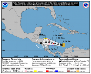
The storm is approximately 54 hours from landfall as of the latest NHC forecast, and currently has peak 1-minute sustained winds of 60mph(95km/h). Synoptics ahead of the system look extremely favorable, with sea surface temperatures near 29 degrees centigrade and forecasted dual upper-level outflow ventilation that has been seen in rapidly intensifying storms like Dorian last year. Likely for these reasons, the NHC explicitly forecasts Iota to rapidly intensify, that is intensify 35mph in 24 hours, for only the fourth time this year. SHIPS rapid intensification indices also give the system a rather large chance of rapid intensification, near 50%. Remember that very rapid intensification is not usually forecast by agencies or deterministic modeling due to large uncertainty in such rapid intensification, so Iota could very well be stronger than its forecasted 115mph(185km/h) major hurricane landfall. In particular, the HWRF and HMON models show this scenario playing out, with the HMON taking the system up to 155mph(250km/h) and near the north end of the guidance envelope. In other news, Iota is far more organized than it was earlier today, and rapid intensification may have already begun. Again, remember that Iota could be far stronger than forecast at landfall.
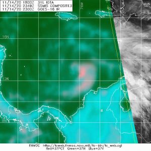
An in-depth analysis of Iota’s interior structure reveals a mid-level eye feature and an organized inner core, again more organized than it was earlier. Considering that Iota was also intensifying at a rather rapid rate earlier, it may intensify significantly faster after this organization. The imagery to the left visualizes this eye feature as the cyan-pinkish curvature near the center around the green. The pink band extending south and then west is the system’s main rain band. Keep in mind that the system is currently organizing and dynamic, and information could change at any time.
Iota also presents significant hazards in the landfall region that have been exacerbated by the effects of Eta earlier this month. Eta’s rains caused landslides and major flooding, while saturating the ground. Some areas still have yet to recover from this flooding, while Eta’s rains in general have weakened the soil in the region, making it far more susceptible to more landslides. Iota’s landfall will only amplify this threat, and could become a major humanitarian crisis like Hurricane Mitch did in 1998. Keep in mind that the storm surge and winds are also significant threats to life, and all precautions should be taken to prevent damage to property or life.
Currently, a Hurricane Warning is in effect for Providencia, the Nicaraguan coast north of Sandy Bay Sirpi, and the Honduran coast east of Punta Pacuta. A hurricane warning means that winds of 64kts or higher are expected somewhere in the warning area and are issued 36 hours before the forecasted arrival of gale-force winds. San Andres is under a Hurricane Watch, and other nearby areas in Honduras and Nicaragua are under Tropical Storm Warnings. A Hurricane Watch means that winds of 64kts or higher are possible in the area and are issued 48 hours before the forecasted arrival of gale-force winds. A Tropical Storm Warning means that gale-force winds are expected within the area in 36 hours or less. Again, other interests should monitor the progress of the system due to the aforementioned possibly catastrophic flooding effects.
From a purely meteorological standpoint, Iota is an extreme anomaly. If the forecast verifies, it will be the first time that there have been 2 major hurricanes in November, while also being one of the most intense tropical cyclones ever in the month of November. It will also be the first time 2 major hurricane landfalls have happened in Nicaragua in the same year, let alone the same month. The fact that one can say such a thing demonstrates 2020’s extreme activity.
For more information on the system please visit the National Hurricane Center website at nhc.noaa.gov and take a look at the Key Messages and Public Advisory for the storm. Furthermore, please use your local officials as the final source of information, as their information will be much more specific and useful to you as a person, and evacuate if needed. Stay tuned for updates, and most importantly, stay safe.

Good job, Wer!