Isaias Regains Hurricane Strength as it Closes in on the Carolina Coast; Strong Winds and Heavy Rainfall Expected Across Much of the U.S East Coast

After holding a relatively constant intensity for the past 48 hours or so, Isaias is strengthening again as it approaches the Carolina coast, and is now once again a hurricane. Isaias is expected to maintain its strength as a Category 1 hurricane during the next few hours leading up to landfall likely near the North Carolina/South Carolina border. Heavy rainfall from the outer bands of Isaias is currently moving onshore, and winds are expected to increase during the next few hours as the center of the storm approaches the coast. All preparations along the U.S East Coast should be rushed to completion, as Isaias is expected to quickly make its way up the coast during the next 48 hours, with hazardous conditions spreading into the Carolinas and Mid-Atlantic tonight and into the Northeast Tuesday afternoon.
Hurricane Isaias: Latest Storm Information
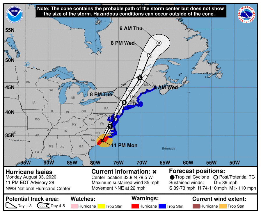
As of the National Hurricane Center’s most recent advisory on Isaias at 8:00 PM EDT (00:00 UTC), the center of Hurricane Isaias was located near 33.8°N, 78.5°W, about 25 mi (35 km) east-northeast of Myrtle Beach, South Carolina, and about 50 mi (80 km) southwest of Wilmington, North Carolina Maximum sustained winds are near 75 mph (120 km/h) with gusts to 100 mph (155 km/h), and the minimum central pressure is 988 mb (29.18 inches). Tropical storm-force winds extend outward up to 125 mi (205 km) from the center, and hurricane-force winds extend outward up to 25 mi (35 km) from the center. Isaias is moving toward the north-northeast at around 22 mph (35 km/h), and Isaias is forecast to gradually, then quickly accelerate northeastward through Tuesday. On the NHC’s forecast track, the center of Isaias will make landfall in southern North Carolina within the next 5 hours. The center will be moving near or over the Mid-Atlantic coast and Chesapeake Bay on Tuesday morning, and then continue along the Northeast coast on Tuesday evening. Little change in strength is expected up to landfall, although only gradual weakening is expected as Isaias moves inland over the next day or two. By Thursday morning, Isaias is forecast to become post-tropical over southern Canada near the St. Lawrence River.
External Links
Please refer to the National Hurricane Center and National Weather Service websites for further information regarding Hurricane Isaias as well as watches and warnings in effect. Force Thirteen will be providing live coverage on Hurricane Isaias as conditions warrant. More information can be found at Force Thirteen’s official outlets, including its Twitter and Facebook pages.

Wow!This is so crazy!