July 2021 Worldwide Cyclone Summary

Tropics:
Northern Atlantic Basin: Hurricane Elsa:
On July 1, Potential Tropical Cyclone Five formed in the Atlantic’s Main Development Region (MDR), and it further intensified into Tropical Storm Elsa later in the day. Elsa later intensified into a category 1 hurricane after making a close pass in Barbados before making landfall in Saint Lucia. The storm made landfall in Cuba on July 5 as a strong Tropical Storm. The storm passed by the Florida Keys the following day and later became a low-end category 1 hurricane. The storm weakened to a tropical storm that night and continued to weaken until it made landfall in Florida. Elsa made landfall in Florida the following day and caused flooding across the Eastern United States.
Eastern Pacific (including Central Pacific): Major Hurricane Felicia, Tropical Storm Guillermo, Tropical Depression Nine-E, and Hurricane Hilda
Felicia: On July 14, Tropical Depression Five-E formed and was quickly named Felicia. Felicia started to intensify and became a hurricane the following day. It quickly intensified for the next 36 hours and achieving an annular look. Force Thirteen has analyzed Felicia to peaked at 165 mph Category 5 Major Hurricane, while the NHC has Felicia’s peak only at 145 mph. Felicia then slowly weakened as it traveled into the drier and colder part of the Eastern Pacific and turned a remnant low by the 19th.
Guillermo: As Felicia was on its weakening trend, Tropical Depression Seven-E formed and later intensified into Tropical Storm Guillermo. Guillermo then steadily intensified and peaked at 60 mph storm. It then encountered unfavorable conditions and became a remnant low the next day.
Nine-E and Hilda: A pair of Tropical Depressions formed on July 30, one of which intensified into Tropical Storm Hilda. Tropical Depression Nine-E failed to get named, but it is still active as a disturbance together with Hilda and other disturbances.

Western Pacific: Tropical Depression 07W (Emong), Tropical Depression 08W, Typhoon In-fa (Fabian), Typhoon Cempaka, and Subtropical Storm Nepartak
07W (Emong): July 2nd, a disturbance west of Marianas has been monitored and within the next 48 hours the JMA, JTWC, and PAGASA upgraded the system to a tropical depression, designating it as 07W. On July 6, PAGASA issued its last advisory and lifted related warnings on Tropical Depression “Emong” as it moved outside the Phillipines area of responsibility. Later that day, JMA and JTWC also issued their last advisories.
08W: PAGASA and JTWC started to monitor a disturbance in Luzon traveling northwestward to the South China Sea. After days of monitoring the system and an eventual landfall in Hainan, the system organized and received the designation 08W. By the night of that day, it made landfall in Vietnam and quickly disorganized; all advisories have been discontinued.
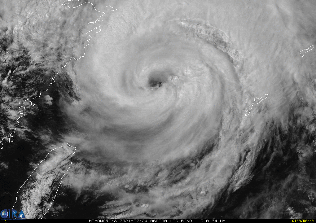
In-fa (Fabian): On July 14th, an area of low pressure west-northwest of Guam was monitored. Located in an area favorable for intensification, PAGASA, JTWC, and JMA upgraded the disturbance to a Tropical Depression as it entered the Philippine Area of Responsibility, resulting in the name Fabian. On July 18th, JMA upgraded it to a tropical storm assigning the name In-fa. The intensification phase continued and it became a typhoon by the 20th. It continued for another day with JTWC peaking it at 110 mph (1-min) and Force Thirteen slightly higher at 115 mph (1-min). Numerous dry-air intrusions and an eyewall replacement cycle made In-fa to quickly weaken into a Category 1 typhoon. It spent two days deviating as a (Severe) Tropical Storm and a Typhoon as it took aim towards Hangzhou Bay. At around noontime local time in the 24th, it made landfall on Putuo Island, Zhejiang, China. Days after landfall, in the 30th, In-fa turned extratropical.
Okinawa Prefecture in Japan took some brunt of In-fa with some high winds and high waves. Chinese authorities took some measures as In-fa posed a flooding threat as the city of Zhengzhou (northwest of the landfall area) recorded deadly flooding.
Cempaka: A disturbance gradually developed as it moved towards the South China Sea and received the designation 10W on the 18th. It intensified and got named as Cempaka the next day. The storm quickly intensified for the next 48 hours. Slightly weakening due to land interaction as it barely moved, Cempaka made landfall on the 20th in Guangdong China. It rapidly weakened inland in Guangdong. It held on as a tropical cyclone but with no body of water to gather energy, Cempaka dissipated by the 24th.
Nepartak: On the 22nd, JTWC started to monitor a disturbance connected to a monsoon trough. Tracking northeastward, the system slowly organized, with the circulation still elongated. The next day, JMA named it as Nepartak. The JTWC, however only designated it as Tropical Depression 11W. By the 24th, Nepartak was guided north-northeastwards by an upper-level low and a trough, it made landfall in Miyagi Prefecture. Some rowing events in the Tokyo 2020 Olympics have been canceled because of the bad weather brought by Nepartak.
SIGNIFICANT EARTHQUAKES of the MONTH
California: the 8th, a Mag. 6.0 earthquake in California referred as the “2021 Antelope Valley earthquake” triggered rockslides in California and Nevada. It was the largest earthquake to strike California since the 2019 Ridgecrest earthquake two years prior.
Tajikistan: A couple of days later, a Mag. 5.8 earthquake in Tajikistan killed five people with thirty others sustaining injuries, and destroyed 20 houses in two villages.
Alaska: On the 29th, a Mag. 8.2 earthquake jolted Alaska. Referred as the “2021 Chignik earthquake” it became the largest earthquake of 2021, it is also the largest earthquake in the United States since the 1965 Rat Islands earthquake. A small tsunami measuring at 21.3 cm (0.7 ft) was recorded in Old Harbor, Alaska and a 15.2 cm (0.5 ft) tsunami wave was recorded both in Sand Point, Alaska and Kodiak, Alaska.
