Kimi moving parallel to the Queensland Coast, bringing winds and heavy rain there.

Kimi strengthened more today, heading close to category 1 in the Saffir-simpson Hurricane Scale (SSHS). But it is expected to weaken soon with increasing wind shear striking it. Currently it is bringing some winds and heavy rainfall to the coast of Queensland, and now it’s forecasted to continue its south-southeast movement and weakening trend, then make a U-turn after stalling tomorrow.
Current Storm Information
As of 06:00UTC (16:00AEST), January 18 2021, according to latest Bureau of Meteorology analysis, Kimi is located at 17.8S 147.0E as a category 2 tropical cyclone, with maximum 10-minute sustain winds of 100km/h and a minimum central pressure of 987hPa, moving south-southeast at 14km/h. Warning zone (gale winds expected within 24hour) is now in effect from Innisfail to Avr, and watch zone (gale winds expected between 24 and 48 hours) is now in effect from Avr to Bowen, where the area of impact is all at the coast of Queensland.
While at the same time the latest ATCF has Kimi a tropical storm still at 17.8S 147.2E with maximum 1-minute sustain winds of 55kts and a pressure of 991mb.
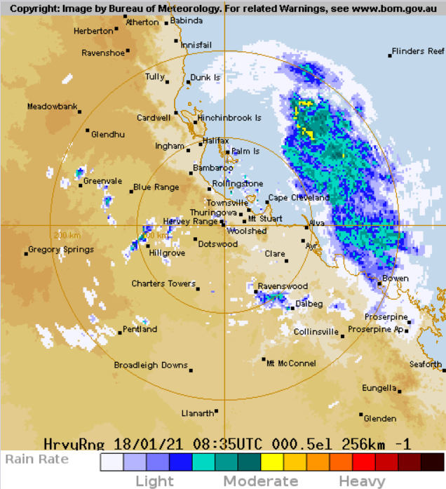
Kimi’s structure improved as seen from the radar imagery as an radar eye has formed and becomes closed before weakening starts. In the morning, Artington Reef recorded a minimum central pressure of 1001.0hPa with sustain winds of 63km/h at 07:06AEST, along with Doppler radar at Cairns measured a radial wind reading of 74mph at 1km elevation at 09:04AEST, which translated to around 90 km/h 10-minute sustain surface winds. Then in the afternoon Townsville radar even gave consistent 80-85mph radial wind readings at 3km elevation, and this supports Bureau of Meteorology’s analysis of around 100km/h.
Forecast Track
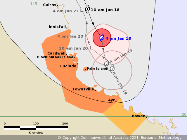
Kimi refused to follow the previous forecast cones and move southwest, making landfall near Cairns. Instead, Kimi continues to move south to south-southeast, more or less parallel to the coast. Kimi developed quickly with the aid of over 29C sea-surface temperature and low wind shear, great outflow conditions brought by an upper-level anticyclone (ULAC) right above it in the past 2 days. But as it continues to leave the ULAC and move southwards, ULAC will in turn give more northwesterly vertical wind shear and hence it’s expected to weaken substantially to a remnant low two day later. Also, it is also forecasted that Kimi will stall tomorrow and then make a U-turn along its previous track. Although Kimi will soon start to degenerate, it is still prognosticated to bring rainfall again to the coast of Queensland affected by Kimi before, and coastal areas might experience flooding impacts.
Please pay attention to the latest warnings and precaution from the local agencies. Stay safe.
Elsewhere in the tropics, 2 tropical storms, Joshua and Eloise persist in the southwest Indian Ocean, which the latter may bring devastating impact to Madagascar and Mozambique as models consistently predicting Eloise will intensify to be an intense cyclone and make landfall on Madagascar and Mozambique.
